
Total Eclipse or Bust! A Family Road Trip
By Patricia Totten Espenak
|
Total Eclipse or Bust! A Family Road Trip 
Full Color Edition $14.99 |

Description
"TOTAL Eclipse or Bust! A Family Road Trip" is a book for the entire family. The story follows a typical family on a road trip to see the 2017 total eclipse of the Sun. Along the way the children learn all about the how and why of eclipses in a friendly and an uncomplicated way. The book also provides basic information about how to view a total solar eclipse and where to go for America's great eclipse on August 21, 2017.
About the Author
Patricia Totten Espenak is a retired chemistry teacher and amateur astronomer who has traveled widely with her husband, Fred, to view various celestial events, including Total and Annular Solar Eclipses, Lunar Eclipses, and Transits of Mercury and Venus.
She has traveled to 16 total solar eclipses with destinations such as India, Zambia, Tahiti, Turkey, Libya, the Galapagos Islands and Antarctica.
Between packing and unpacking, she enjoys hiking with Fred in the Chiricahua Mountains near their home and viewing the wonderfully dark skies of southeastern Arizona.
Total Eclipse or Bust! A Family Road Trip - Sample Pages
Also Available!
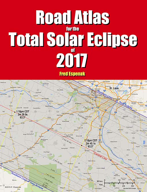
Road Atlas for the Total Solar Eclipse of 2017
The Road Atlas for the Total Solar Eclipse of 2017 is a complementary publication of the 2017 Eclipse Bulletin. It contains a comprehensive series of 37 high resolution, full color maps of the path of totality across the USA.
The large scale (1:700,000 or 1 inch = 11 miles) shows both major and minor roads, towns and cities, rivers, parks, and mountains.
Armed with this atlas and the latest weather forecasts, the road warrior is ready to chase totality no matter where it takes him/her along the 2500-mile-long path. This mobile strategy offers the highest probability of witnessing the spectacular 2017 total eclipse in clear skies.
For more information visit Road Atlas for the Total Solar Eclipse of 2017.
Eclipse Bulletin: Total Solar Eclipse of 2017 August 21
The Eclipse Bulletin: Total Solar Eclipse of 2017 August 21 is the complementary publication of the 2017 Road Atlas and is the ultimate guide to this highly anticipated event.
Local circumstances tables for more than 1000 cities across the USA provide times of each phase of the eclipse along with the eclipse magnitude, duration and Sun's altitude. Additional tables cover the eclipse circumstances for cities in Canada, Mexico, Central and South America and Europe. An exhaustive climatological study identifies areas along the eclipse path where the highest probability of favorable weather may be found. A travelogue highlights key locations in the eclipse track from Oregon through South Carolina.
Finally, comprehensive information is presented about solar filters and how to safely observe and photograph the eclipse.
For more information visit Eclipse Bulletin: Total Solar Eclipse of 2017 August 21.
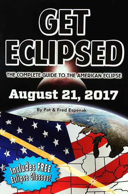
Get Eclipsed: The Complete Guide to the American Eclipse
Get Eclipsed is an easy to read, family friendly, inexpensive 2017 eclipse guide for everyone, especially if the total eclipse of the Sun on August 21, 2017 will be your first one.
Get Eclipsed features:
- How and Why Solar Eclipses Happen
- Science and History of Solar Eclipses
- Fun Facts for the Entire Family
- Helpful Hints for Safe Viewing
- Illuminating Maps and Diagrams
- Eclipse times for over a hundred cities
- Two (2) pairs of Solar Eclipse Glasses
For more information visit Get Eclipsed: The Complete Guide to the American Eclipse.
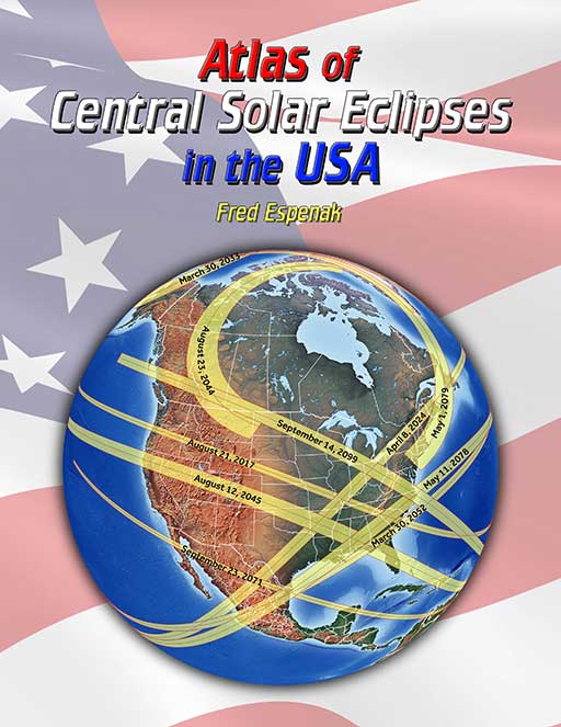
Atlas of Central Solar Eclipses in the USA
The Atlas of Central Solar Eclipses in the USA contains of a series of 499 global maps showing the geographic track of every total and annular solar eclipse across the USA (including Alaska and Hawaii) during the two-thousand-year period 1001 through 3000. It is accompanied by a catalog that lists the major characteristics of each eclipse including its duration and whether it is visible from the lower 48 states, Alaska and/or Hawaii.
A set of 20 detailed maps, each covering a 50-year period and centered on the lower 48 states, shows the path of every total and annular eclipse. The maps include state boundaries and major cities. These maps also cover southern Canada and northern Mexico.
For more information visit Atlas of Central Solar Eclipses in the USA.