Eclipses During 2013
By Fred Espenak
Based on the Article Published in
Observer's Handbook 2013,
Royal Astronomical Society of Canada
In 2013, there are two solar eclipses and three lunar eclipses as follows.
| Eclipses During 2013 | |||
| 2013 Apr 25: Partial Lunar Eclipse | |||
| 2013 May 10: Annular Solar Eclipse | |||
| 2013 May 25: Penumbral Lunar Eclipse | |||
| 2013 Oct 18: Penumbral Lunar Eclipse | |||
| 2013 Nov 03: Hybrid Solar Eclipse | |||
| Eclipses During 2013 | ||||
|
Partial Lunar Eclipse 2013 Apr 25 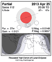
|
Annular Solar Eclipse 2013 May 10 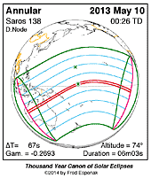
|
Penumbral Lunar Eclipse 2013 May 25 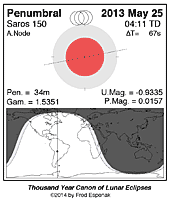
|
Penumbral Lunar Eclipse 2013 Oct 18 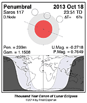
|
Hybrid Solar Eclipse 2013 Nov 03 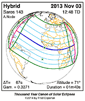
|
Predictions for the eclipses are summarized in Figures 1, 2, 3, 4, 5, and 6. World maps show the regions of visibility for each eclipse. The lunar eclipse diagrams also include the path of the Moon through Earth's shadows. Contact times for each principal phase are tabulated along with the magnitudes and geocentric coordinates of the Sun and Moon at greatest eclipse.
Click for larger more detailed figure
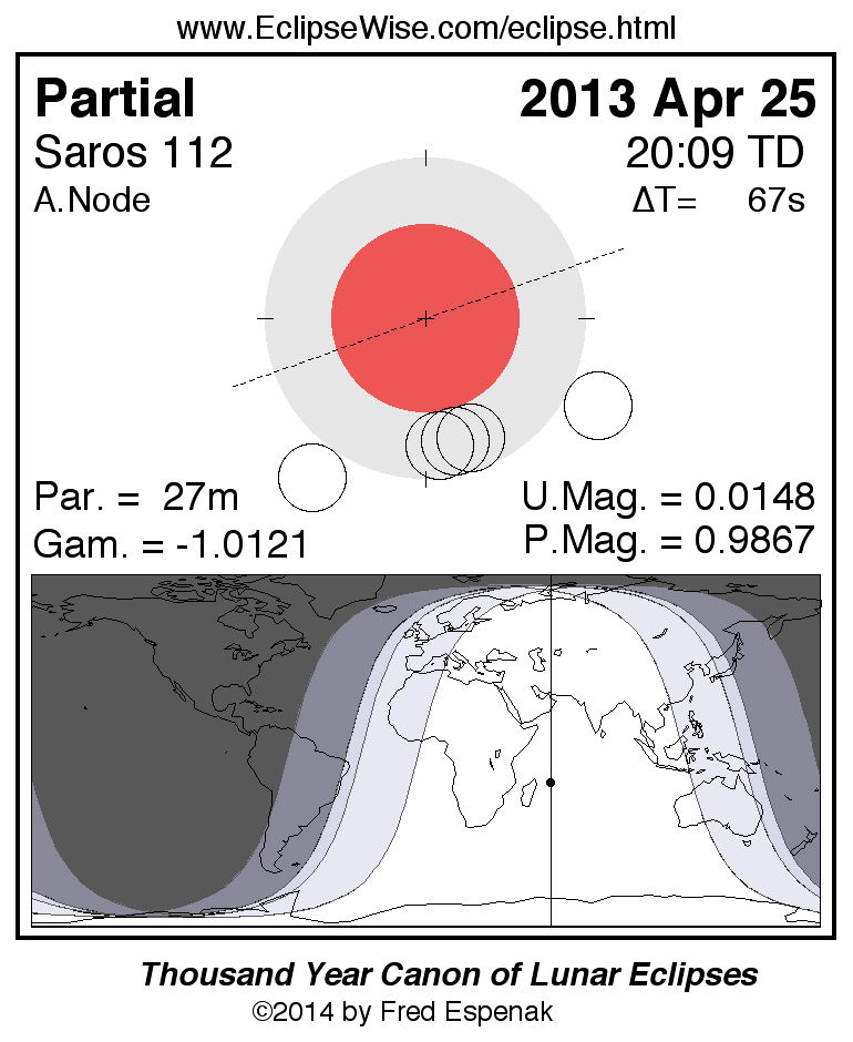
Partial Lunar Eclipse of 2013 Apr 25
The first lunar eclipse of 2013 occurs at the Moon's ascending node in southern Virgo about 12° east of Spica (mv = +1.05). It is visible primarily from the Eastern Hemisphere. The Moon's contact times with Earth's shadows are listed below.
               Penumbral Eclipse Begins:  18:03:38 UT
               Partial Eclipse Begins:    19:54:08 UT
               Greatest Eclipse:          20:07:30 UT
               Partial Eclipse Ends:      20:21:02 UT
               Penumbral Eclipse Ends:    22:11:26 UT
At the instant of greatest eclipse[1] the umbral eclipse magnitude will reach 0.0147. This event is barely partial with just 0.5 arc-minutes of the Moon's northern limb dipping into umbral shadow. Consequently, the partial phase lasts less than 27 minutes.
Figure 1 shows the path of the Moon through the penumbra and umbra as well as a map of Earth showing the regions of eclipse visibility. To catch the entire event, one must be located in eastern Europe or Africa, central Asia or western Australia. At the instant of greatest eclipse the Moon will be at the zenith for an observer just east of Madagascar. Eastern parts of South America will experience moonrise with the eclipse already in progress, but none of the eclipse is visible from North America.
The April 25 eclipse belongs to Saros 112, a series of 72 eclipses in the following sequence: 7 penumbral, 21 partial, 15 total, 22 partial, and 7 penumbral lunar eclipses (Espenak and Meeus, 2009). In particular, the April 25 event is the last partial eclipse in Saros 112.
Complete details for the 72 eclipses in the series may be found at Saros 112.
For more information about this eclipse, see the EclipseWise Prime Page at Partial Lunar Eclipse of 2013 Apr 25
Click for larger more detailed figure
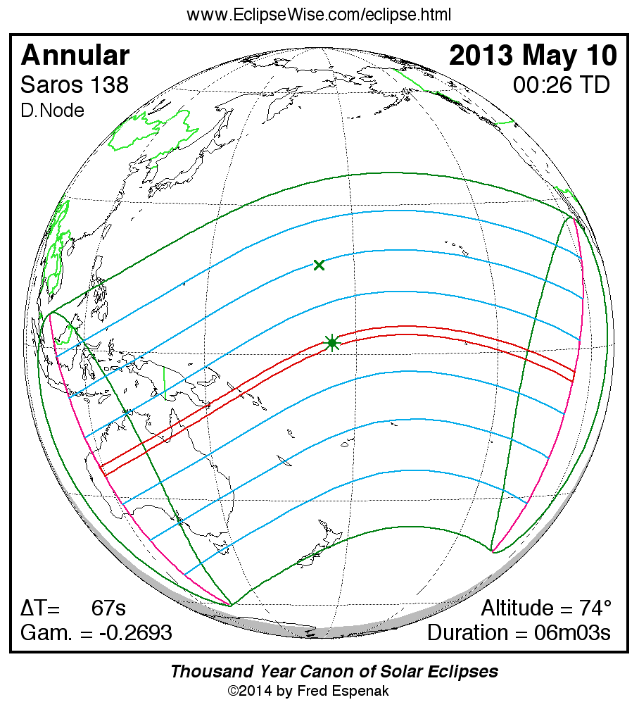
Annular Solar Eclipse of 2013 May 10
The first solar eclipse of 2013 occurs at the Moon's descending node in eastern Ares. An annular eclipse will be visible from a 171 to 225 kilometre-wide track that traverses Australia, eastern Papua New Guinea, the Solomon Islands, and the Gilbert Islands. A partial eclipse is seen within the much broader path of the Moon's penumbral shadow, which includes Australia, Indonesia, Oceania and much of the central the Pacific Ocean (Figure 2).
The annular path begins in Western Australia near Collier Range National Park at 22:33 UT. Because the Moon passes through apogee just 3 1/2 days later (May 13 at 13:32 UT), its large distance from Earth produces a wide path of annularity. Traveling northeast, the shadow quickly sweeps across the Northern Territory where Tennent Creek experiences an annular phase of 3 minutes 4 seconds. Since the eclipse occurs here shortly after sunrise, the Sun is just 16° above the horizon. On the central line 70 km to the north, annularity lasts 4 minutes 27 seconds at 22:37 UT.
The antumbral shadow crosses the Gulf of Carpentaria and reaches the Cape York Peninsula at 22:44 UT. As it does so, it crosses the track of the previous year's total solar eclipse (2012 November 13). Four minutes later, the shadow departs Australia at Lakefield National Park (22:48 UT).
The next landfall in the eclipse path occurs in eastern Papua New Guinea at 23:00 UT. The central line crosses Basilaki Island where annularity lasts 4 minutes 59 seconds with the Sun at an altitude of 39°. Traveling at 0.98 km/s, the antumbra next reaches the Solomons where Choiseul, the largest island in the chain, lies at the center of the track. Annularity is now 5 minutes 16 seconds and the Sun is 49° above the horizon (23:15 UT). This is the last major landfall in the path.
As the antumbral track curves to the east, it encounters Tarawa atoll in the Gilbert Islands (Republic of Kiribati). The duration of the annular phase reaches the 6-minute mark here at 00:15 UT. The annular ring is quite thick because the Moon appears only 95% the diameter of the Sun.
The instant of greatest eclipse [2] occurs at 00:26:20 UT when the eclipse magnitude [3] will reach 0.9544. At that instant, the duration of annularity is 6 minutes 3 seconds, the path width is 173 kilometres and the Sun is 74° above the flat horizon formed by the open ocean.
The shadow passes just north of Kiribati with no other landfall of any consequence occurring over the remainder of the track. At 02:20 UT, the antumbral leaves Earth's surface as the annular path ends.
During the course of its 3/4-hour trajectory, the antumbra's track is approximately 13,300 kilometres long and covers 0.50% of Earth's surface area. Path coordinates and central line circumstances are presented in Table 1 at five-minute intervals. The first column gives the Universal Time (UT) while the next six columns define the northern and southern limits as well as the central line coordinates at that instant. The Sun's altitude at maximum eclipse is given, followed by the width of the central path and the duration of totality.
Partial phases of the eclipse are visible primarily from Australia, New Zealand and Indonesia. Local circumstances for a number of cities are found in Table 2. All times are given in Universal Time. The Sun's altitude and azimuth, the eclipse magnitude and obscuration [4] are all given at the instant of maximum eclipse.
This is the 31st eclipse of Saros 138 [5] (Espenak and Meeus, 2006). The family began with a series of 7 partial eclipses starting on 1472 Jun 06. The first annular eclipse was on 1616 Sep 11. After a series of 50 consecutive annular eclipses, Saros 138 will produce one hybrid and three total eclipses before it terminates on 2716 Jul 11 after a final nine partial eclipses. Complete details for the 70 eclipses in the series (in the sequence of 7 partial, 50 annular, 1 hybrid, 3 total, and 9 partial) may be found at: Saros 138.
For more information about this eclipse, see the EclipseWise Prime Page at Annular Solar Eclipse of 2013 May 10.
Click for larger more detailed figure
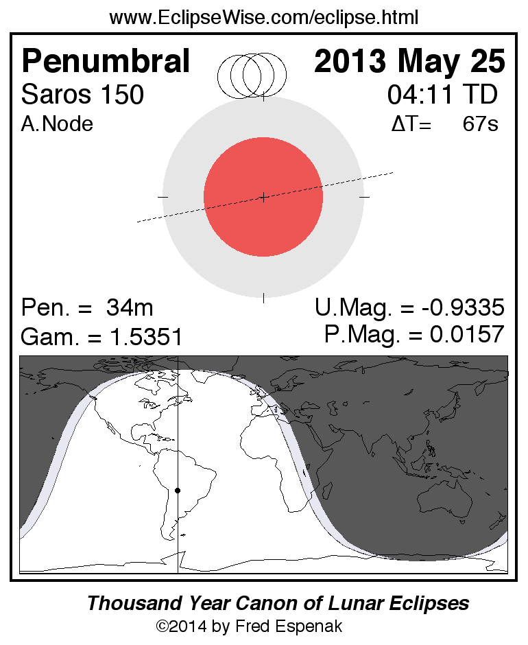
Penumbral Lunar Eclipse of 2013 May 25
The second lunar eclipse of the year again occurs at the Moon's ascending node in Scorpius about 7° northwest of Antares (mv = +1.07). With a penumbral eclipse magnitude [6] of 0.0158, just 0.5 arc-minutes of the Moon's southern limb will pass into Earth's pale penumbral shadow; such a shallow eclipse is only of academic interest since it will be all but impossible to detect.
Nevertheless, the Moon's contact times with Earth's penumbra are listed below.
               Penumbral Eclipse Begins:   03:53:11 UT
               Greatest Eclipse:           04:10:00 UT
               Penumbral Eclipse Ends:     04:26:56 UT
During the event, the Moon will be visible from the Americas and western Africa. Figure 3 shows the path of the Moon through the penumbra as well as a map showing the geographic regions of visibility.
The May 25 penumbral lunar eclipse is the very first eclipse of Saros 150, a series of 71 eclipses in the following sequence: 8 penumbral, 23 partial, 12 total, 15 partial, and 13 penumbral lunar eclipses (Espenak and Meeus, 2009). Saros 150 peaks with a total eclipse on 2680 Jul 04 and it ends on 3275 Jun 30. Complete details for the series can be found at: Saros 150.
For more information about this eclipse, see the EclipseWise Prime Page at Penumbral Lunar Eclipse of 2013 May 25
Click for larger more detailed figure
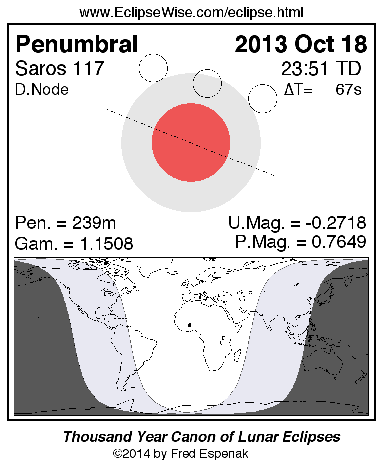
Penumbral Lunar Eclipse of 2013 Oct 18
The last lunar eclipse of the year is a relatively deep penumbral eclipse with a magnitude of 0.7649. It should be easily visible to the naked eye as a dusky shading in the southern half of the Moon. The times of the major phases are listed below.
               Penumbral Eclipse Begins:  21:50:38 UT
               Greatest Eclipse:          23:50:17 UT
               Penumbral Eclipse Ends:    01:49:49 UT
Note that the beginning and end of a penumbral eclipse are not visible to the eye. In fact, no shading can be detected until about 2/3 of the Moon's disk is immersed in the penumbra. This would put the period of nominal eclipse visibility from about 23:30 to 00:10 UT. Keep in mind that this is only an estimate. Atmospheric conditions and the observer's visual acuity are important factors to consider. An interesting exercise is to note when penumbral shading is first and last seen.
Figure 4 shows the path of the Moon through the penumbra as well as a map of Earth showing the regions of eclipse visibility. Eastern Canada will see the entire event while the rest of Canada and the USA will see moonrise with the eclipse already in progress. Observers in Europe and Africa will also see the entire event, while eastern Asia misses the end because of moonset.
The October 18 penumbral lunar eclipse is the 52nd member of Saros 117, a series of 71 eclipses in the following sequence: 8 penumbral, 9 partial, 24 total, 7 partial, and 23 penumbral lunar eclipses (Espenak and Meeus, 2009). Complete details for the series can be found at: Saros 117.
For more information about this eclipse, see the EclipseWise Prime Page at Penumbral Lunar Eclipse of 2013 Oct 18
Click for larger more detailed figure
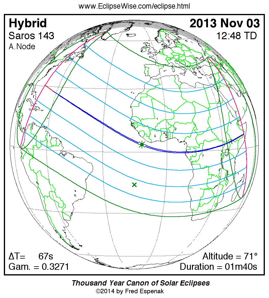
Hybrid Solar Eclipse of 2013 Nov 03
The final event of 2013 is the most interesting eclipse of the year. It is one of the rare hybrid or annular/total eclipses in which some sections of the path are annular while other parts are total. The duality comes about when the vertex of the Moon's umbral shadow pierces Earth's surface at some locations, but falls short of the planet along other sections of the path. The unusual geometry is due to the curvature of Earth's surface that brings some geographic locations into the umbra while other positions are more distant and enter the antumbral rather than umbral shadow. In most cases, the central path begins annular, changes to total for the middle portion of the track, and reverts back to annular towards the end of the path. However, November 3 eclipse is even more unique because the central path to begins annular and ends total. Because hybrid eclipses occur near the vertex of the Moon's umbral/antumbral shadows, the central path is typically quite narrow.
The hybrid eclipse of 2013 is visible from within a thin corridor, which traverses the North Atlantic and equatorial Africa. A partial eclipse is seen within the much broader path of the Moon's penumbral shadow, which includes eastern North America, northern South America, southern Europe, the Middle East and Africa (Figure 5).
The path of the Moon's shadow begins in the North Atlantic approximately 1000 km due east of Jacksonville, FL. From the central line, a 4 second annular eclipse is visible at sunrise (11:05 UT). As the shadow races forward, the narrow 4 km wide path rapidly shrinks to zero and the eclipse changes from annular to total. This all transpires within the first 15 seconds of the shadow's trajectory. For the remainder of the track, the eclipse remains total.
Continuing on a southeast course, the vertex of the umbral shadow passes progressively deeper into Earth as the planet's curvature brings the path along the surface closer to the Moon. By 11:10 UT, the track is 13 km wide and totality lasts 16 seconds. Growing quickly, the duration reaches 30 seconds by 11:18 UT.
With no landfall yet in sight, the shadow passes 500 km south of Cape Verde at 12:00 UT. On the central line, totality now lasts 1 minute 18 seconds, the Sun's altitude is 57°, and the path width is 56 km.
Greatest eclipse occurs in the Atlantic at 12:47:36 UT, approximately 330 kilometres southwest of Liberia. At this instant, the axis of the Moon's shadow passes closest to Earth's centre. The maximum duration of totality is 1 minute 39 seconds, the Sun's altitude is 71°, and the path width is 57 kilometres.
Slowly curving to the east, the track just misses Sao Tome and Principe and intercepts the coast of Gabon north of Port-Gentil in the Wonga Wongue Reserve (13:51 UT) where the central line duration is 1 minute 7 seconds and the Sun's altitude is 46°. The Moon's shadow crosses Gabon in 9 minutes and sweeps over the Congo in 7 more. Entering the Democratic Republic of the Congo, the path width is 36 kilometres and the duration is 48 seconds (Figure 6).
The track begins curving to the northeast as it narrows and the duration of totality decreases. By the time the umbra reaches the western border of Uganda, totality drops to 23 seconds with the Sun at 18° (14:22 UT). Sweeping over northern Kenya, the path crosses Lake Turkana where the central line duration is 14 seconds at 14:25 UT.
In its final 2 1/2 minutes, the lunar shadow races across southern Ethiopia before leaving Earth's surface in Somalia where a 1 second total eclipse occurs at sunset.
Over the course of 3.3 hours, the Moon's umbra travels along a path approximately 13,600 kilometres long and covers 0.09% of Earth's surface area. Path coordinates and central line circumstances are presented in Table 3. The Universal Time (UT), the northern and southern limits, and the central line coordinates are given at five-minute intervals. The Sun's altitude at maximum eclipse is followed by the width of the central path and the duration of totality.
Local circumstances for a number of cities are found in Table 4. All times are given in Universal Time. The Sun's altitude and azimuth, the eclipse magnitude and obscuration are all given at the instant of maximum eclipse.
This is the 23rd eclipse of Saros 143 (Espenak and Meeus, 2006). The series began on 1617 Mar 07 with a string of 10 partial eclipses. The first of 12 total eclipses occurred on 1797 Jun 24. The 2013 event is the first of 4 hybrids of the series before transitioning to pure annular eclipses beginning 2085 Dec 16. The series ends with a set of 20 partial eclipses the last of which occurs on 2897 Apr 23.
In all, Saros 143 produces 72 eclipses in the sequence of 10 partial, 12 total, 4 hybrid, 26 annular, and 20 partial eclipses. Complete details for the series can be found at: Saros 143
For more information about this eclipse, see the EclipseWise Prime Page at Hybrid Solar Eclipse of 2013 Nov 03.
Explanatory Information
Solar Eclipse Figures
Lunar Eclipse Figures
Shadow Diameters and Lunar Eclipses
Danjon Scale of Lunar Eclipse Brightness
Crater Timings During Lunar Eclipses
Eclipse Altitudes and Azimuths
The altitude a and azimuth A of the Sun or Moon during an eclipse depend on the time and the observer's geographic coordinates. They are calculated as follows:
         h = 15 (GST + UT - α ) + λ
         a = arcsin [sin δ sin φ + cos δ cos h cos φ]
         A = arctan [-(cos δ sin h)/(sin δ cos φ - cos δ cos h sin φ)]

where

         h = hour angle of Sun or Moon
         a = altitude
         A = azimuth
         GST = Greenwich Sidereal Time at 0:00 UT
         UT = Universal Time
         α = right ascension of Sun or Moon
         δ = declination of Sun or Moon
         λ = observer's longitude (east +, west -)
         φ = observer's latitude (north +, south -)
During the eclipses of 2013, the values for GST and the geocentric Right Ascension and Declination of the Sun or the Moon (at greatest eclipse) are as follows:
Eclipse              Date           GST         α          δ

Partial Lunar     2013 Apr 25     14.266     14.214     -14.426
Annular Solar     2013 May 10     15.198      3.138      17.610
Penumbral Lunar   2013 May 25     16.194     16.153     -19.413
Penumbral Lunar   2013 Oct 18      1.842      1.572      11.003
Hybrid Solar      2013 Nov 03      2.863     14.589     -15.206
Two web based tools that can also be used to calculate the local circumstances for all solar and lunar eclipses visible from any location. They are the Javascript Solar Eclipse Explorer and the Javascript Lunar Eclipse Explorer. The URLs for these tools are:
Javascript Solar Eclipse Explorer: www.EclipseWise.com/solar/JSEX/JSEX-index.html
Javascript Lunar Eclipse Explorer: www.EclipseWise.com/lunar/JLEX/JLEX-index.html
Eclipses During 2014
In 2014, there are two solar eclipses and two total lunar eclipses:
| Eclipses During 2014 | |||
| 2014 Apr 15: Total Lunar Eclipse | |||
| 2014 Apr 29: Annular Solar Eclipse | |||
| 2014 Oct 08: Total Lunar Eclipse | |||
| 2014 Oct 23: Partial Solar Eclipse | |||
| Eclipses During 2014 | |||
|
Total Lunar Eclipse 2014 Apr 15 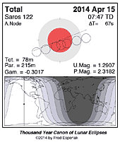
|
Annular Solar Eclipse 2014 Apr 29 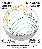
|
Total Lunar Eclipse 2014 Oct 08 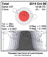
|
Partial Solar Eclipse 2014 Oct 23 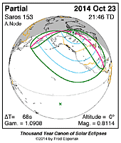
|
A full report Eclipses During 2014 will be published in Observer's Handbook:2014
Eclipse Web Sites
EclipseWise.com is a website dedicated to predictions and information on eclipses of the Sun and Moon. It offers a graphically intuitive interface and contains maps, diagrams, tables, and information about every solar and lunar eclipse from 2000 BCE to 3000 CE. This period includes 11898 solar eclipses and 12064 lunar eclipses.
Much of EclipseWise.com is based on the Thousand Year Canon of Solar Eclipses 1501 to 2500 (Espenak 2014a) and the Thousand Year Canon of Lunar Eclipses 1501 to 2500 (Espenak 2014b). These eclipse predictions use the Jet Propulsion Lab's DE406 — a computer ephemeris used for calculating high precision coordinates of the Sun and Moon for thousands of years into the past and future.
For eclipses over a larger time interval see Five Millennium Canon of Solar Eclipses –1999 to +3000 and Five Millennium Canon of Lunar Eclipses –-1999 to +3000.
The World Atlas of Solar Eclipses provides maps of all central eclipse paths from 2000 BCE to 3000 CE.
MrEclipse.com targets solar and lunar eclipse photography, with tips on eclipse observing and eye safety.
For web versions of this article for other years, visit the following:Eclipse Publications
|

|
|
|
|
|
Acknowledgments
All eclipse predictions were generated on an Apple Power Mac G4 computer using algorithms developed from the Explanatory Supplement [1974] with additional algorithms from Meeus, Grosjean, and Vanderleen [1966]. The solar coordinates used in the eclipse predictions are based on VSOP87 [P. Bretagnon and G. Francou, 1988]. The lunar coordinates are based on ELP-2000/82 [M. Chapront-Touzé and J. Chapront, 1983]. For lunar eclipses, the diameter of the umbral and penumbral shadows were calculated using Danjon's rule of enlarging Earth's radius by 1/85 to compensate for the opacity of the terrestrial atmosphere; corrections for the effects of oblateness have also been included. Text and table composition was done on a Macintosh using Microsoft Word. Additional figure annotation was performed with Claris MacDraw Pro.
All calculations, diagrams, tables, and opinions presented in this paper are those of the author, and he assumes full responsibility for their accuracy.
Permission is granted to reproduce the eclipse data when accompanied by a link to this page and an acknowledgment:
"Eclipse Predictions by Fred Espenak, EclipseWise.com"
The use of diagrams and maps is permitted provided that they are unaltered (except for re-sizing) and the embedded credit line is not removed or concealed.
Footnotes
[1] Umbral eclipse magnitude is defined as the fraction of the Moon's diameter occulted by the umbral shadow.
[2] The instant of greatest eclipse for solar eclipses occurs when the distance between the Moon's shadow axis and Earth's geocentre reaches a minimum.
[3] Eclipse magnitude for solar eclipses is defined as the fraction of the Sun's diameter occulted by the Moon.
[4] Eclipse obscuration is defined as the fraction of the Sun's area occulted by the Moon.
[5] The Saros is a period of 6,585.3 days (18 years 11 days 8 hours) in which eclipses (both solar and lunar) repeat. The geometry isn't exact but close enough for a Saros series to last 12 or more centuries.
[6] Penumbral eclipse magnitude is defined as the fraction of the Moon's diameter occulted by the penumbral shadow.
References
Bretagnon P., Francou G., "Planetary Theories in rectangular and spherical variables: VSOP87 solution", Astron. and Astrophys., vol. 202, no. 309 (1988).
Chapront-Touzé, M and Chapront, J., "The Lunar Ephemeris ELP 2000," Astron. and Astrophys., vol. 124, no. 1, pp 50-62 (1983).
Chauvenet, W., Manual of Spherical and Practical Astronomy, Vol.1, 1891 (Dover edition 1961).
Danjon, A., "Les éclipses de Lune par la pénombre en 1951," L'Astronomie, 65, 51-53 (Feb. 1951).
Espenak, F., Meeus, J., Five Millennium Canon of Solar Eclipses –1999 to +3000, 2nd Edition, AstroPixels Publishing, Portal, AZ, 2021.
Espenak, F., Meeus, J., Five Millennium Canon of Lunar Eclipses –-1999 to +3000, 2nd Edition, AstroPixels Publishing, Portal, AZ, 2021.
Espenak, F., Thousand Year Canon of Solar Eclipses 1501 to 2500, AstroPixels Publishing, Portal, AZ, 2014.
Espenak, F., Thousand Year Canon of Lunar Eclipses 1501 to 2500, AstroPixels Publishing, Portal, AZ, 2014.
Espenak, F., 21st Century Canon of Solar Eclipses, AstroPixels Publishing, Portal, AZ, 2016.
Espenak, F., 21st Century Canon of Lunar Eclipses, AstroPixels Publishing, Portal, AZ, 2020.
Espenak, F., Atlas of Central Solar Eclipses in the USA, AstroPixels Publishing, Portal, AZ, 2016.
Explanatory Supplement to the Astronomical Ephemeris and the American Ephemeris and Nautical Almanac, Her Majesty's Nautical Almanac Office, London, 1974.
Littmann, M., Espenak, F., & Willcox, K., Totality—Eclipses of the Sun, 3rd Ed., Oxford University Press, New York, 2008.
Meeus, J., Grosjean, C.C., & Vanderleen, W., Canon of Solar Eclipses, Pergamon Press, New York, 1966.
Meeus, J. & Mucke, H., Canon of Lunar Eclipses: -2002 to +2526, Astronomisches Buro, Wien, 1979.
Eclipse Publications
|
|
|

|