
Total Eclipse of the Sun: April 08, 2024
by Fred Espenak
Introduction
On Monday, April 8, 2024, a total eclipse of the Sun will be visible from the contiguous United States for the first time since 2017. The track of the Moon's umbral shadow begins in the Pacific Ocean and crosses northern Mexico before reaching the USA. Traveling southwest to northeast, it sweeps through parts of fifteen states: Texas, Oklahoma, Arkansas, Missouri, Tennessee, Kentucky, Illinois, Indiana, Ohio, Michigan, Pennsylvania, New York, Vermont, New Hampshire, and Maine. The path of totality also crosses six Canadian provinces: Ontario, Quebec, New Brunswick, Prince Edward Island, Nova Scotia, and Newfoundland. Within the 101 to 124 mile-wide path of totality, the Moon will completely cover the Sun as the landscape is plunged into an eerie twilight and the Sun's glorious corona is revealed for nearly 4 1/2 minutes.
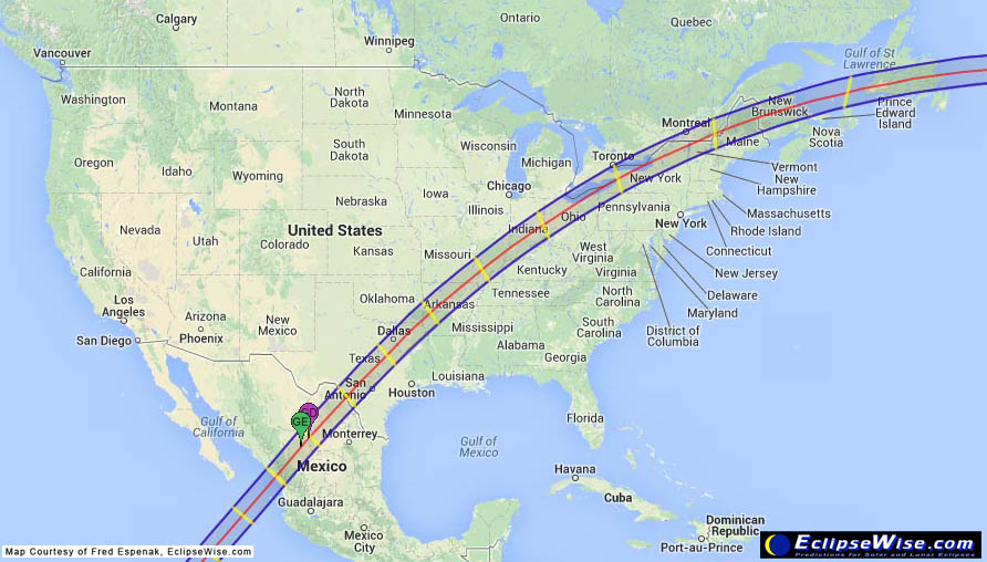
Path of the 2024 Total Solar Eclipse
(click to enlarge)
This special web page contains information about the 2024 total eclipse of the Sun. It will be updated with additional details as eclipse day approaches.
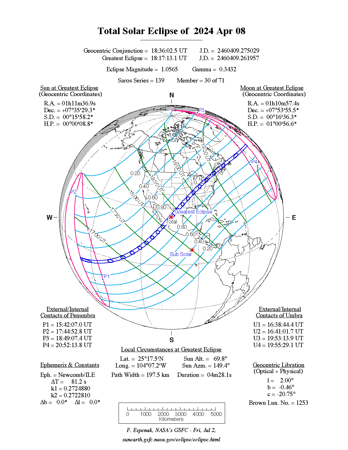
The EclipseWise Prime Page for the 2024 April 08 eclipse presents detailed information on this event including the primary eclipse characteristics, conjunction times, geocentric coordinates of the Sun and Moon, lunar libration values, penumbral and umbral shadow contact data, central line data, polynomial Besselian elements and additional links.
Path of Totality
A table of the geographic coordinates for the path of totality are available below.
Orthographic Map of the Total Solar Eclipse
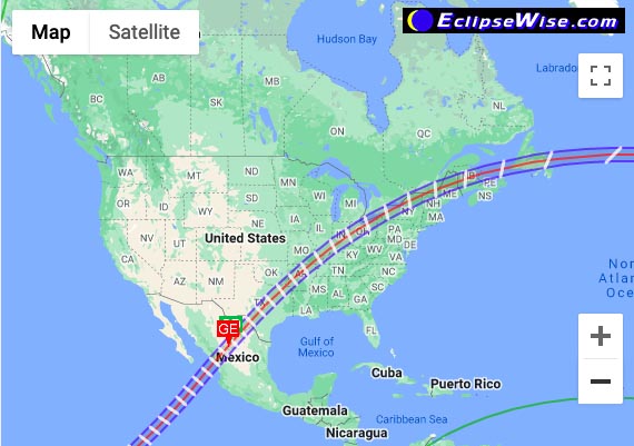
The following map shows the overall regions of visibility of the partial eclipse as well as the center of the Total eclipse through Mexico, the USA, and Canada. It uses coastline data from the World Data Base II (WDB).
Path of the 2024 Total Eclipse through North America
(click to enlarge)
Intermediate Detail Maps of the Path of Totality
The following maps show the path of the 2024 total solar eclipse in intermediate detail for locations across North America. The path of totality is shaded for clarity, and lines of maximum eclipse have been plotted (in yellow) at 10-minute intervals. The Coordinated Universal Time (UTC), the duration of totality (minutes:seconds) and the Sun's altitude (degrees) is given on the eclipse central line at 10-minute intervals. The maps also include cities, major towns, highways, rivers, lakes and parks.
Interactive GoogleMap of the Path of Totality
An implementation of Google Map has been created which includes the central path of the 2024 total solar eclipse. This allows the user to select any portion of the path and to zoom in using either map data or Earth satellite data.
Safe Eclipse Viewing
 Order Safe Eclipse Glasses from American Paper Optics (click here)
Every total eclipse of the Sun begins and ends with a partial eclipse. The partial phases require either a projection technique or a special solar filter to be viewed safely. Read more about this at Safe Solar Eclipse Viewing.
Of course during the few brief minutes of Totality when the Sun's disk is completely covered by the Moon, it is then safe to look directly at the Sun with the naked eye or through a telescope or binoculars.
- Safe Solar Eclipse Viewing - summarizes several safe ways to view an eclipse of the Sun
- Solar Filters and Eclipse Glasses - a list of links
- How to Safely View a Solar Eclipse
- A Guide to Safe Solar Filters
- Sources for Solar Filters
- Telescope Manufacturers
- Telescope & Accessory Retailers

Safe Solar Eclipse Glasses |

Rainbow Symphony Eclipse Shades |

Thousand Oaks Optical Solar Filters |

Great American Eclipse Store |
Books About the 2024 Eclipse
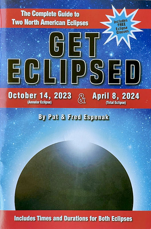
Get Eclipsed: A Family Guide to Two North American Eclipses
North America will be the scene for two spectacular eclipses of the Sun. On October 14, 2023, an annular eclipse of the Sun occurs in western USA and Mexico. Six months later, an incomparable total eclipse of the Sun occurs on April 8, 2024. Its 125-mile wide path crosses Mexico, the USA from Texas to Maine, and eastern Canada.
During both of these events, a partial eclipse of the Sun will be visible from virtually all of North America. The last annular eclipse visible from the USA was in 2012. The last total eclipse visible from the USA was in 2017, and the next one to cross the country won't be until 2044. Don't miss the incredible experience of seeing these celestial wonders!
Get Eclipsed is an easy to read, family friendly, inexpensive eclipse guide for the entire family. It tells you everything you need to know about the upcoming annular and total eclipses of the Sun in 2023 and 2024. And it comes with two pairs of special glasses for safely watching the partial eclipse phases and annularity.
For more information visit Get Eclipsed.
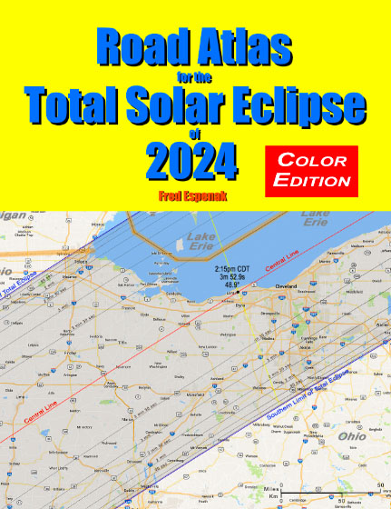
Road Atlas of the Total Solar Eclipse of 2024
The Road Atlas for the Total Solar Eclipse of 2024 contains a comprehensive series of 26 maps of the path of totality across Mexico, the USA and Canada. The large scale (1 inch ≈ 22 miles) shows both major and minor roads, towns and cities, rivers, parks, and mountains.
Although a partial eclipse will be seen from all of North America, the total phase in which the Moon completely covers the Sun (known as totality) will only be seen from within the 120-mile-wide path of the Moon’s umbral shadow as it sweeps across Mexico, the United States (Texas, Oklahoma, Arkansas, Missouri, Tennessee, Kentucky, Illinois, Indiana, Ohio, Michigan, Pennsylvania, New York, Vermont, New Hampshire, and Maine), and Canada (Ontario, Quebec, New Brunswick, Prince Edward Island, Nova Scotia and Newfoundland).
Armed with this atlas and the latest weather forecasts, the road warrior is ready to chase totality no matter where it takes him/her along the entire path. This mobile strategy offers the highest probability of witnessing the spectacular 2024 total eclipse in clear skies.
For more information visit Road Atlas for the Total Solar Eclipse of 2024.
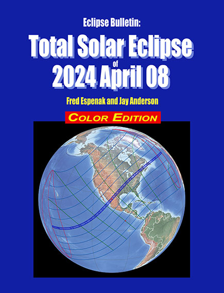
Eclipse Bulletin: Total Solar Eclipse of 2024 April 08
The Eclipse Bulletin: Total Solar Eclipse of 2024 April 08 is the complementary publication of the 2024 Road Atlas and is the ultimate guide to this highly anticipated event.
Eleven high resolution maps plot the total eclipse track across Mexico, the USA, and Canada. The large map scale (1 inch ≈ 53 miles) shows hundreds of cities and towns in the path, the location of major roads and highways, and the duration of totality with distance from the central line. Local circumstances tables for hundreds cities the USA, Canada, and Mexico provide times of each phase of the eclipse along with the eclipse magnitude, duration and Sun's altitude. A detailed climatological study identifies areas along the eclipse path where the highest probability of favorable weather may be found.
Finally, comprehensive information is presented about solar filters and how to safely observe the eclipse.
For more information visit Eclipse Bulletin: Total Solar Eclipse of 2024 April 08.
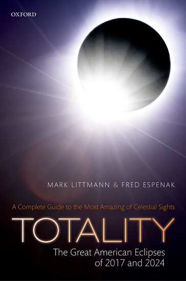
Totality - The Great American Eclipses of 2017 and 2024
The Totality - The Great American Eclipses of 2017 and 2024 is a complete guide to the most stunning of celestial sights, total eclipses of the Sun. It focuses on the eclipses of August 21, 2017 and April 8, 2024 that pass across the United States. The U.S. mainland has not experienced a total solar eclipse since 1979. This book provides information, photographs, and illustrations to help understand and safely enjoy all aspects of these eclipses including:
- How to observe a total eclipse of the Sun
- How to photograph and video record an eclipse
- Why solar eclipses happen
- The earliest attempts to understand and predict eclipses
- The mythology and folklore of eclipses
- The response of animals to total solar eclipses
- The response of man to total eclipses through time
- How scientists used total eclipses to understand how the Sun works
- How astronomers used a total eclipse in 1919 to confirm Einstein's general theory of relativity
- Weather prospects for the 2017 eclipse
- Detailed maps of the path of totality for the 2017 eclipse and the eclipses of 2018 through 2024
- Precise local times for the eclipses of 2017 and 2024 (the next total solar eclipse to visit the U.S.)
- Color and black-and-white photographs, diagrams, and charts to illustrate and explain total solar eclipses
- Global maps of total solar eclipses from 2017 to 2045 and lists of total and annual solar eclipses from 1970 through 2070
For more information visit Totality - The Great American Eclipses of 2017 and 2024.
2024 Eclipse Bulletin Extras
- Eclipse Bulletin: Total Solar Eclipse of 2024 April 08 - More information and sample pages from this book
- Coordinates for Path of Grazing Eclipse - major resources and links for the eclipse
- Lunar limb profile from Central line an 19:15 UTC
Additional Links for 2024 April 08 Total Solar Eclipse
- Prime Page: Total Solar Eclipse of 2024 Apr 08 - EclipseWise general information on the eclipse
- Special News Page: Total Solar Eclipse of 2024 Apr 08 - major resources and links for the eclipse
- Orthographic Map: Total Solar Eclipse of 2024 Apr 08 - detailed map of eclipse visibility
- Animated Map: Total Solar Eclipse of 2024 Apr 08 - animated map of the Moon's shadows across Earth
- Google Map: Total Solar Eclipse of 2024 Apr 08 - interactive map of the eclipse path
- Path Table: Total Solar Eclipse of 2024 Apr 08 - coordinates of the central line and path limits
- Circumstances Table: Total Solar Eclipse of 2024 Apr 08 - eclipse times for hundreds of cities
- Saros 139 Table - data for all eclipses in the Saros series
- Total Solar Eclipse of 2024 Apr 08 - Google search for links to this eclipse
- Great American Eclipse - an exhaustive collection of maps and merchandise for the 2024 eclipse by Michael Zeiler
- Eclipse 2024 - a comprehensive website by Dan McGlaun
- National Eclipse - Dave Clark's website on the 2024 eclipse
- Eclipsophile.com - Weather for the 2024 Eclipse

The Total Solar Eclipse of 2006 Mar 29 as seen from Jalu, LIBYA.
(click to visit photo gallery)
Links to Additional Solar Eclipse Information
- Home - home page of EclipseWise with predictions for both solar and lunar eclipses
- Solar Eclipses - primary page for solar eclipse predictions
- Solar Eclipse Links - detailed directory of links
- 21st Century Catalog of Solar Eclipses - including the years 2001 to 2100
- Total Solar Eclipses in the USA - maps for all total solar eclipses in the USA from 1001 to 3000
- Annular Solar Eclipses in the USA - maps for all annular solar eclipses in the USA from 1001 to 3000
- Hybrid Solar Eclipses in the USA - maps for all hybrid solar eclipses in the USA from 1001 to 3000
- Javascript Solar Eclipse Explorer - find all solar eclipses visible from a city
- Six Millennium Catalog of Solar Eclipses - covers the years -2999 to +3000 (3000 BCE to 3000 CE)
- Catalog of Solar Eclipse Saros Series - covers Saros series -29 through 190
- Javascript Solar Eclipse Explorer - calculate all lunar eclipses visible from a city
- Thousand Year Canon of Solar Eclipses 1501 to 2500 - link to the publication
Solar Eclipse Photography
- Solar Eclipse Photography: How to Photograph a Solar Eclipse (MrEclipse)
- Solar Eclipse Photography: How to Photograph a Solar Eclipse (Nikon)
- Solar Eclipse Photographs: Index to Solar Eclipse Photographs
- Solar Eclipse Reports: Index to Solar Eclipse Reports
Solar Eclipse Viewing
- Solar Eclipses for Beginners - a primer on solar eclipse basics
- Safe Solar Eclipse Viewing - summarizes several safe ways to view an eclipse of the Sun
- Solar Filter and Eclipse Glasses - a list of links
- Observing Solar Eclipses Safely - instructions for safely viewing an eclipse of the Sun