
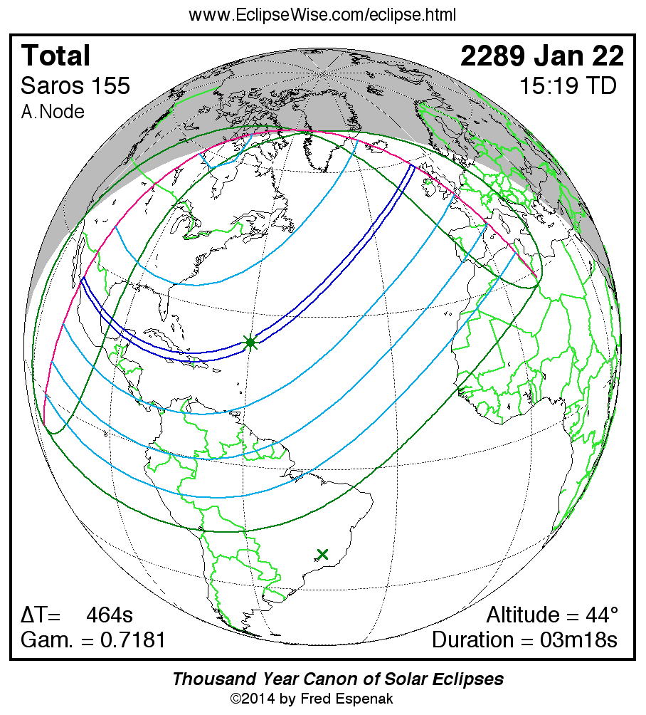
Path of the Total Solar Eclipse of 2289 Jan 22
Fred Espenak
Introduction
The following table delineates the path of the Moon's umbral shadow during the Total Solar Eclipse of 2289 Jan 22 . The geographic coordinates (WGS 84) of the northern and southern limits and the central line are listed at 120-second intervals. This provides adequate detail for making plots of the path on larger scale maps. Local circumstances on the central line include the ratio of the apparent diameters of the Moon to the Sun, the Sun's altitude and azimuth (degrees), the path width (kilometers) and the duration on the central line (minutes and seconds). See the Explanation of the Central Eclipse Path Table for a description of each column in the table.
The geographic visibility of the eclipse is shown on a global map on the Prime Page for the Eclipse which also includes complete details on the eclipse. The path of the eclipse is displayed in greater detail on an interactive Google Map .
| Total Solar Eclipse of 2289 Jan 22 | |||||||||||
| UT1 | Northern Limit | Southern Limit | Central Line | M:S | Sun | Sun | Path | Central | |||
| Latitude | Longitude | Latitude | Longitude | Latitude | Longitude | Ratio | Alt. | Azm. | Width | Duration | |
| Limits | 26°06.5'N | 107°19.7'W | 25°06.6'N | 107°27.6'W | 25°36.4'N | 107°23.6'W | 1.025 | 0° | - | 108 km | 01m30.4s |
| 14:00 | - | - | 22°53.3'N | 101°05.1'W | 24°24.5'N | 103°59.2'W | 1.026 | 3° | 113° | 113 km | 01m36.8s |
| 14:02 | 23°25.6'N | 099°10.0'W | 21°25.1'N | 096°17.5'W | 22°23.2'N | 097°36.7'W | 1.028 | 10° | 116° | 124 km | 01m50.5s |
| 14:04 | 22°20.5'N | 095°17.2'W | 20°35.0'N | 093°11.0'W | 21°26.9'N | 094°11.1'W | 1.029 | 14° | 118° | 130 km | 01m58.8s |
| 14:06 | 21°39.4'N | 092°29.4'W | 20°00.1'N | 090°44.2'W | 20°49.3'N | 091°34.9'W | 1.030 | 16° | 119° | 135 km | 02m05.5s |
| 14:08 | 21°10.1'N | 090°13.0'W | 19°34.3'N | 088°40.2'W | 20°21.9'N | 089°25.2'W | 1.030 | 19° | 120° | 140 km | 02m11.3s |
| 14:10 | 20°48.3'N | 088°15.9'W | 19°14.6'N | 086°51.5'W | 20°01.2'N | 087°32.6'W | 1.031 | 21° | 121° | 144 km | 02m16.5s |
| 14:12 | 20°31.8'N | 086°32.2'W | 18°59.5'N | 085°13.9'W | 19°45.5'N | 085°52.1'W | 1.032 | 23° | 122° | 148 km | 02m21.2s |
| 14:14 | 20°19.4'N | 084°58.5'W | 18°48.0'N | 083°44.8'W | 19°33.5'N | 084°20.9'W | 1.032 | 25° | 123° | 151 km | 02m25.6s |
| 14:16 | 20°10.2'N | 083°32.6'W | 18°39.6'N | 082°22.5'W | 19°24.8'N | 082°56.9'W | 1.033 | 26° | 125° | 154 km | 02m29.8s |
| 14:18 | 20°03.8'N | 082°12.9'W | 18°33.6'N | 081°05.8'W | 19°18.6'N | 081°38.8'W | 1.033 | 28° | 126° | 157 km | 02m33.6s |
| 14:20 | 19°59.6'N | 080°58.5'W | 18°29.9'N | 079°53.8'W | 19°14.6'N | 080°25.6'W | 1.033 | 29° | 127° | 160 km | 02m37.2s |
| 14:22 | 19°57.5'N | 079°48.3'W | 18°28.0'N | 078°45.7'W | 19°12.7'N | 079°16.5'W | 1.034 | 30° | 128° | 163 km | 02m40.7s |
| 14:24 | 19°57.1'N | 078°41.9'W | 18°27.9'N | 077°41.0'W | 19°12.4'N | 078°11.0'W | 1.034 | 31° | 129° | 165 km | 02m43.9s |
| 14:26 | 19°58.4'N | 077°38.8'W | 18°29.3'N | 076°39.4'W | 19°13.8'N | 077°08.6'W | 1.034 | 32° | 130° | 168 km | 02m46.9s |
| 14:28 | 20°01.1'N | 076°38.4'W | 18°32.1'N | 075°40.3'W | 19°16.5'N | 076°08.9'W | 1.035 | 33° | 131° | 170 km | 02m49.8s |
| 14:30 | 20°05.1'N | 075°40.5'W | 18°36.3'N | 074°43.5'W | 19°20.6'N | 075°11.7'W | 1.035 | 34° | 132° | 172 km | 02m52.5s |
| 14:32 | 20°10.3'N | 074°44.8'W | 18°41.6'N | 073°48.9'W | 19°25.9'N | 074°16.5'W | 1.035 | 35° | 133° | 173 km | 02m55.1s |
| 14:34 | 20°16.7'N | 073°51.1'W | 18°48.1'N | 072°56.0'W | 19°32.3'N | 073°23.3'W | 1.035 | 36° | 134° | 175 km | 02m57.5s |
| 14:36 | 20°24.2'N | 072°59.2'W | 18°55.6'N | 072°04.9'W | 19°39.8'N | 072°31.7'W | 1.036 | 37° | 136° | 176 km | 02m59.8s |
| 14:38 | 20°32.7'N | 072°08.8'W | 19°04.2'N | 071°15.2'W | 19°48.4'N | 071°41.7'W | 1.036 | 38° | 137° | 178 km | 03m01.9s |
| 14:40 | 20°42.2'N | 071°19.9'W | 19°13.7'N | 070°26.9'W | 19°57.8'N | 070°53.1'W | 1.036 | 39° | 138° | 179 km | 03m03.9s |
| 14:42 | 20°52.5'N | 070°32.2'W | 19°24.1'N | 069°39.8'W | 20°08.3'N | 070°05.8'W | 1.036 | 39° | 139° | 180 km | 03m05.7s |
| 14:44 | 21°03.8'N | 069°45.7'W | 19°35.4'N | 068°53.9'W | 20°19.6'N | 069°19.5'W | 1.036 | 40° | 141° | 181 km | 03m07.4s |
| 14:46 | 21°16.0'N | 069°00.2'W | 19°47.6'N | 068°08.9'W | 20°31.7'N | 068°34.4'W | 1.037 | 40° | 142° | 181 km | 03m09.0s |
| 14:48 | 21°28.9'N | 068°15.7'W | 20°00.6'N | 067°24.9'W | 20°44.7'N | 067°50.1'W | 1.037 | 41° | 143° | 182 km | 03m10.4s |
| 14:50 | 21°42.7'N | 067°32.1'W | 20°14.5'N | 066°41.7'W | 20°58.5'N | 067°06.7'W | 1.037 | 41° | 145° | 182 km | 03m11.7s |
| 14:52 | 21°57.3'N | 066°49.2'W | 20°29.1'N | 065°59.3'W | 21°13.1'N | 066°24.0'W | 1.037 | 42° | 146° | 182 km | 03m12.8s |
| 14:54 | 22°12.6'N | 066°07.0'W | 20°44.5'N | 065°17.5'W | 21°28.5'N | 065°42.1'W | 1.037 | 42° | 147° | 183 km | 03m13.9s |
| 14:56 | 22°28.8'N | 065°25.4'W | 21°00.6'N | 064°36.3'W | 21°44.6'N | 065°00.7'W | 1.037 | 43° | 149° | 183 km | 03m14.8s |
| 14:58 | 22°45.6'N | 064°44.4'W | 21°17.5'N | 063°55.7'W | 22°01.5'N | 064°19.9'W | 1.037 | 43° | 150° | 182 km | 03m15.6s |
| 15:00 | 23°03.2'N | 064°03.8'W | 21°35.2'N | 063°15.5'W | 22°19.1'N | 063°39.5'W | 1.037 | 43° | 152° | 182 km | 03m16.2s |
| 15:02 | 23°21.6'N | 063°23.7'W | 21°53.6'N | 062°35.8'W | 22°37.4'N | 062°59.6'W | 1.037 | 43° | 153° | 182 km | 03m16.8s |
| 15:04 | 23°40.7'N | 062°43.9'W | 22°12.7'N | 061°56.4'W | 22°56.5'N | 062°20.1'W | 1.037 | 44° | 155° | 181 km | 03m17.2s |
| 15:06 | 24°00.5'N | 062°04.5'W | 22°32.5'N | 061°17.3'W | 23°16.4'N | 061°40.8'W | 1.037 | 44° | 156° | 181 km | 03m17.5s |
| 15:08 | 24°21.0'N | 061°25.2'W | 22°53.1'N | 060°38.5'W | 23°36.9'N | 061°01.8'W | 1.037 | 44° | 158° | 180 km | 03m17.6s |
| 15:10 | 24°42.3'N | 060°46.2'W | 23°14.4'N | 059°59.9'W | 23°58.2'N | 060°22.9'W | 1.037 | 44° | 159° | 179 km | 03m17.7s |
| 15:12 | 25°04.4'N | 060°07.3'W | 23°36.5'N | 059°21.4'W | 24°20.3'N | 059°44.2'W | 1.037 | 44° | 161° | 178 km | 03m17.6s |
| 15:14 | 25°27.1'N | 059°28.4'W | 23°59.3'N | 058°42.9'W | 24°43.1'N | 059°05.6'W | 1.037 | 44° | 162° | 177 km | 03m17.4s |
| 15:16 | 25°50.7'N | 058°49.6'W | 24°22.8'N | 058°04.6'W | 25°06.6'N | 058°27.0'W | 1.037 | 44° | 164° | 176 km | 03m17.1s |
| 15:18 | 26°15.0'N | 058°10.7'W | 24°47.1'N | 057°26.1'W | 25°30.9'N | 057°48.4'W | 1.037 | 44° | 166° | 175 km | 03m16.6s |
| 15:20 | 26°40.1'N | 057°31.7'W | 25°12.2'N | 056°47.6'W | 25°56.0'N | 057°09.6'W | 1.037 | 44° | 167° | 174 km | 03m16.1s |
| 15:22 | 27°06.1'N | 056°52.5'W | 25°38.1'N | 056°09.0'W | 26°21.9'N | 056°30.7'W | 1.037 | 43° | 169° | 173 km | 03m15.4s |
| 15:24 | 27°32.8'N | 056°13.2'W | 26°04.8'N | 055°30.2'W | 26°48.6'N | 055°51.7'W | 1.037 | 43° | 170° | 172 km | 03m14.6s |
| 15:26 | 28°00.4'N | 055°33.5'W | 26°32.3'N | 054°51.1'W | 27°16.2'N | 055°12.3'W | 1.037 | 43° | 172° | 171 km | 03m13.7s |
| 15:28 | 28°28.8'N | 054°53.4'W | 27°00.6'N | 054°11.7'W | 27°44.6'N | 054°32.6'W | 1.037 | 42° | 173° | 170 km | 03m12.7s |
| 15:30 | 28°58.2'N | 054°13.0'W | 27°29.9'N | 053°31.8'W | 28°13.8'N | 053°52.4'W | 1.037 | 42° | 175° | 168 km | 03m11.6s |
| 15:32 | 29°28.5'N | 053°32.0'W | 28°00.0'N | 052°51.5'W | 28°44.1'N | 053°11.8'W | 1.037 | 42° | 176° | 167 km | 03m10.4s |
| 15:34 | 29°59.7'N | 052°50.4'W | 28°31.1'N | 052°10.7'W | 29°15.2'N | 052°30.6'W | 1.037 | 41° | 178° | 166 km | 03m09.0s |
| 15:36 | 30°32.0'N | 052°08.1'W | 29°03.2'N | 051°29.2'W | 29°47.4'N | 051°48.7'W | 1.037 | 41° | 179° | 164 km | 03m07.5s |
| 15:38 | 31°05.3'N | 051°25.0'W | 29°36.3'N | 050°47.0'W | 30°20.6'N | 051°06.1'W | 1.037 | 40° | 181° | 163 km | 03m06.0s |
| 15:40 | 31°39.7'N | 050°41.1'W | 30°10.4'N | 050°04.0'W | 30°54.8'N | 050°22.6'W | 1.036 | 40° | 182° | 161 km | 03m04.3s |
| 15:42 | 32°15.3'N | 049°56.1'W | 30°45.7'N | 049°20.0'W | 31°30.3'N | 049°38.1'W | 1.036 | 39° | 184° | 160 km | 03m02.4s |
| 15:44 | 32°52.1'N | 049°09.9'W | 31°22.2'N | 048°35.0'W | 32°06.9'N | 048°52.6'W | 1.036 | 38° | 185° | 158 km | 03m00.5s |
| 15:46 | 33°30.3'N | 048°22.5'W | 31°59.9'N | 047°48.7'W | 32°44.8'N | 048°05.7'W | 1.036 | 37° | 187° | 157 km | 02m58.5s |
| 15:48 | 34°09.8'N | 047°33.6'W | 32°38.9'N | 047°01.1'W | 33°24.1'N | 047°17.5'W | 1.036 | 37° | 188° | 155 km | 02m56.3s |
| 15:50 | 34°50.9'N | 046°43.0'W | 33°19.4'N | 046°12.0'W | 34°04.8'N | 046°27.6'W | 1.036 | 36° | 190° | 154 km | 02m54.0s |
| 15:52 | 35°33.5'N | 045°50.5'W | 34°01.5'N | 045°21.1'W | 34°47.2'N | 045°36.0'W | 1.035 | 35° | 191° | 152 km | 02m51.6s |
| 15:54 | 36°18.0'N | 044°55.8'W | 34°45.2'N | 044°28.2'W | 35°31.2'N | 044°42.2'W | 1.035 | 34° | 193° | 151 km | 02m49.0s |
| 15:56 | 37°04.3'N | 043°58.7'W | 35°30.7'N | 043°33.1'W | 36°17.2'N | 043°46.1'W | 1.035 | 33° | 194° | 149 km | 02m46.3s |
| 15:58 | 37°52.8'N | 042°58.7'W | 36°18.2'N | 042°35.4'W | 37°05.1'N | 042°47.3'W | 1.035 | 32° | 196° | 147 km | 02m43.5s |
| 16:00 | 38°43.7'N | 041°55.4'W | 37°07.9'N | 041°34.7'W | 37°55.4'N | 041°45.4'W | 1.034 | 31° | 197° | 146 km | 02m40.5s |
| 16:02 | 39°37.2'N | 040°48.3'W | 38°00.1'N | 040°30.5'W | 38°48.2'N | 040°39.7'W | 1.034 | 30° | 199° | 144 km | 02m37.3s |
| 16:04 | 40°33.7'N | 039°36.5'W | 38°55.1'N | 039°22.2'W | 39°43.9'N | 039°29.8'W | 1.034 | 28° | 200° | 142 km | 02m34.0s |
| 16:06 | 41°33.8'N | 038°19.4'W | 39°53.2'N | 038°09.1'W | 40°43.0'N | 038°14.8'W | 1.033 | 27° | 202° | 140 km | 02m30.5s |
| 16:08 | 42°37.9'N | 036°55.5'W | 40°55.0'N | 036°50.2'W | 41°45.9'N | 036°53.5'W | 1.033 | 25° | 203° | 138 km | 02m26.7s |
| 16:10 | 43°47.0'N | 035°23.3'W | 42°01.3'N | 035°24.1'W | 42°53.5'N | 035°24.5'W | 1.032 | 24° | 205° | 136 km | 02m22.7s |
| 16:12 | 45°02.2'N | 033°40.5'W | 43°12.8'N | 033°49.1'W | 44°06.8'N | 033°45.8'W | 1.032 | 22° | 207° | 134 km | 02m18.4s |
| 16:14 | 46°25.3'N | 031°43.5'W | 44°31.0'N | 032°02.3'W | 45°27.3'N | 031°54.2'W | 1.031 | 20° | 209° | 132 km | 02m13.8s |
| 16:16 | 47°59.1'N | 029°26.3'W | 45°58.0'N | 029°59.6'W | 46°57.4'N | 029°44.8'W | 1.030 | 18° | 211° | 129 km | 02m08.6s |
| 16:18 | 49°48.7'N | 026°38.1'W | 47°37.1'N | 027°33.9'W | 48°41.3'N | 027°08.9'W | 1.030 | 15° | 214° | 126 km | 02m02.8s |
| 16:20 | 52°06.2'N | 022°53.1'W | 49°35.4'N | 024°30.8'W | 50°47.9'N | 023°47.6'W | 1.029 | 12° | 217° | 123 km | 01m55.9s |
| 16:22 | 55°38.5'N | 016°26.7'W | 52°10.4'N | 020°12.1'W | 53°44.1'N | 018°42.2'W | 1.027 | 8° | 221° | 118 km | 01m46.6s |
| Limits | 59°05.0'N | 009°09.4'W | 58°14.9'N | 008°07.6'W | 58°40.0'N | 008°37.9'W | 1.025 | 0° | - | 110 km | 01m32.0s |
ΔT = 464.3 seconds
| Greatest Eclipse and Greatest Duration | ||||||||
| Event | Time TD |
Time UT1 |
Latitude | Longitude | Sun Altitude |
Sun Azimuth |
Path Width | Central Duration |
| Greatest Eclipse | 15:19:24.1 | 15:11:39.8 | 24°16.5'N | 061°47.2'W | 43.9° | 160.6° | 178.5 km | 03m17.61s |
| Greatest Duration | 15:17:26.1 | 15:09:41.7 | 23°54.9'N | 060°28.9'W | 43.9° | 159.1° | 179.3 km | 03m17.66s |
Links for the Total Solar Eclipse of 2289 Jan 22
Links to Additional Solar Eclipse Predictions
- Home - home page of EclipseWise with predictions for both solar and lunar eclipses
- Solar Eclipses - primary page for solar eclipse predictions
- Solar Eclipse Links - detailed directory of links
Eclipse Predictions
Predictions for the Total Solar Eclipse of 2289 Jan 22 were generated using the JPL DE406 solar and lunar ephemerides. The lunar coordinates were calculated with respect to the Moon's Center of Mass. Although the predictions are first calculated in Terrestrial Dynamical Time (TD), they are then converted to Universal Time (UT1) as presented here. The parameter ΔT is used to convert between the two times (i.e., UT1 = TD - ΔT). ΔT has a value of 464.3 seconds for this eclipse. The uncertainty in ΔT is 121.4 seconds corresponding to a standard error in longitude of the eclipse path of ± 0.51°.
Acknowledgments
All eclipse calculations are by Fred Espenak, and he assumes full responsibility for their accuracy.
Permission is granted to reproduce eclipse data when accompanied by a link to this page and an acknowledgment:
"Eclipse Predictions by Fred Espenak, EclipseWise.com"
The use of diagrams and maps is permitted provided that they are unaltered (except for re-sizing) and the embedded credit line is not removed or covered.