
2017 Total Solar Eclipse in Wyoming
by Fred Espenak
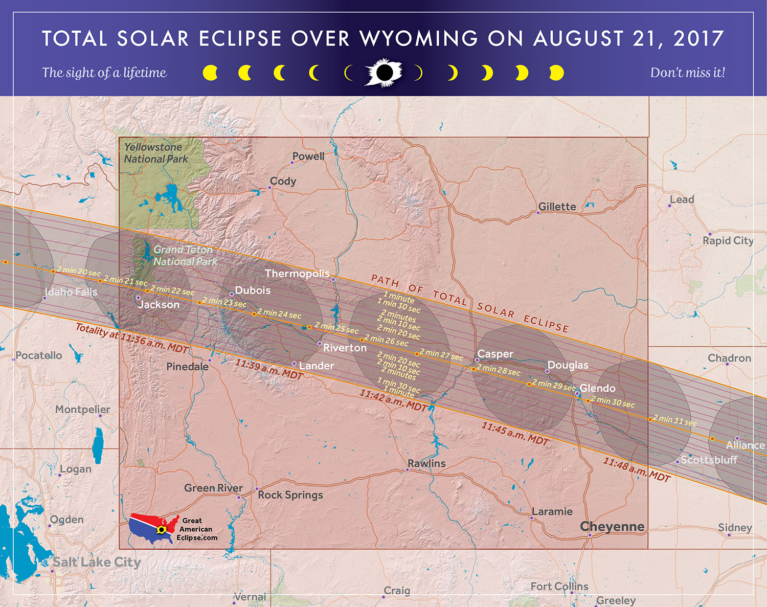
The 2017 Eclipse Path in Wyoming
Map courtesy of Michael Zeiler
GreatAmericanEclipse.com
The 2017 Total Solar Eclipse in Wyoming
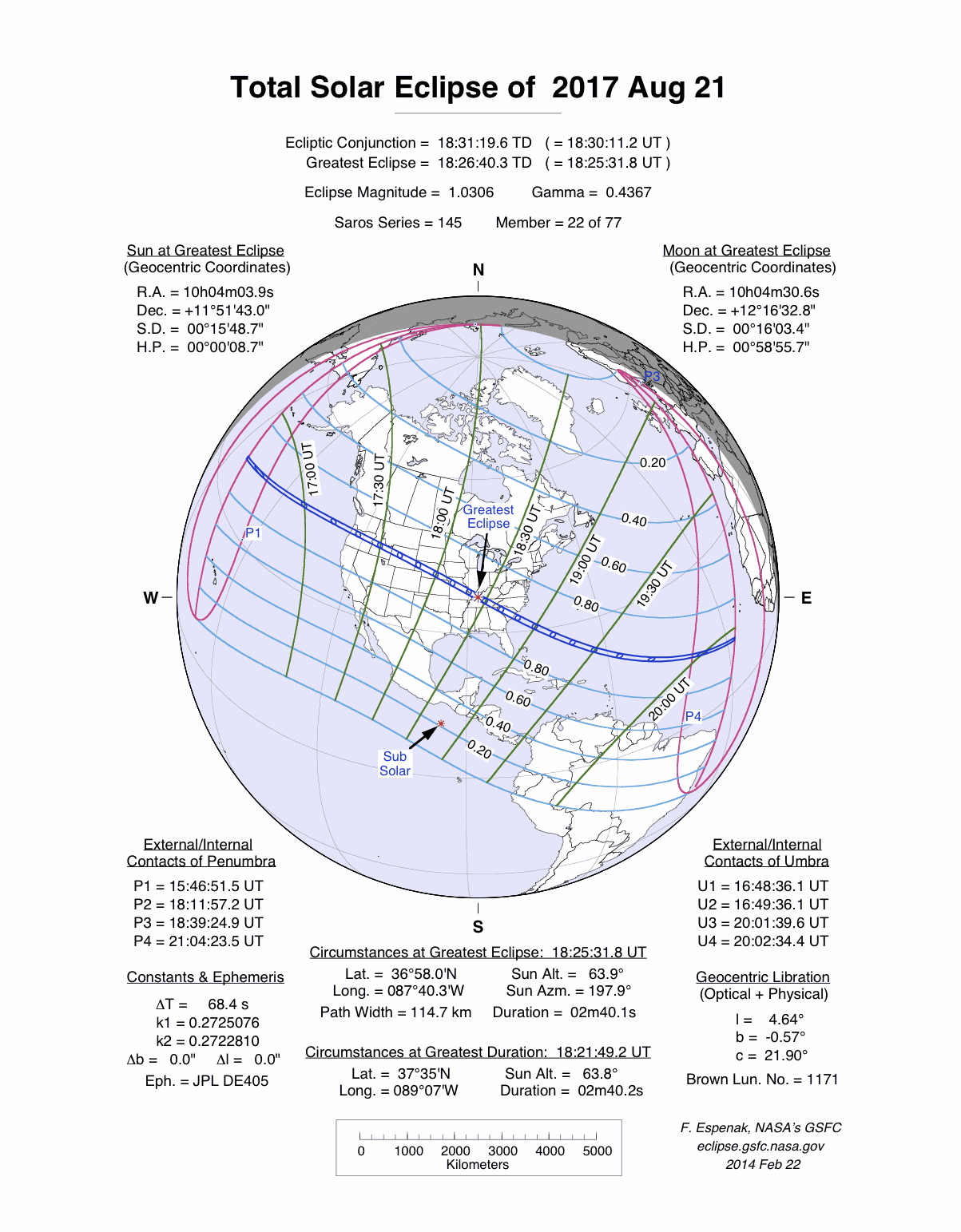
On 2017 August 21, a total eclipse of the Sun is visible from within a narrow corridor that traverses the United States of America. The path of the Moon's umbral shadow begins in northern Pacific and crosses the USA from west to east through parts of the following states: Oregon, Idaho, Wyoming, Nebraska, Kansas, Missouri, Illinois, Kentucky, Tennessee, North Carolina, Georgia, and South Carolina (a tiny corner of Montana and Iowa are also in the path). A partial eclipse visible from a much larger region covering all of North America (See Map).
As it crosses the Teton Range, the Moon's shadow enters western Wyoming and Grand Teton National Park. With its spectacular mountain scenery, the Tetons are always a popular tourist destination. Add a total eclipse and the region will likely experience some serious congestion. The central line passes through Jackson Hole's airport bringing 2 minutes 20 seconds of totality. Teton Park lies on the dry lee side of the mountains so the weather prospects are promising. But the lack of running room and the ability to reach a better location should weather conditions deteriorate on eclipse day could be an issue.
East of the Wind River Range, the eclipse track stretches out across the high desert terrain of Wyoming. The central line passes though Casper where the duration reaches 2 minutes 26 seconds. Offering a mean cloud amount of ~40%, Casper lies at the intersection of good highways running over a 150 kilometres east and west within the eclipse path. The Astronomical League's annual convention AstroCon 2017 will occur in Casper the week prior to the eclipse.
East of Casper, the path engulfs Douglas and Glendo with durations of 2 minutes 22 seconds, and 2 minutes 27 seconds, respectively and continues on to the Wyoming/Nebraska border. Interstate 25 runs 190 miles south to Denver from the central line in Glendo. It is sure to be crowded on eclipse day with traffic from the Mile-High City heading for the path of totality.
Safe Eclipse Viewing
Every total eclipse of the Sun begins and ends with a partial eclipse. The partial phases require either a projection technique or a special solar filter to be viewed safely. Read more about this at Safe Solar Eclipse Viewing.
Of course during the few brief minutes of Totality when the Sun's disk is completely covered by the Moon, it is then safe to look directly at the Sun with the naked eye or through a telescope or binoculars.
Weather Prospects in Wyoming
(Excerpts from Eclipse Bulletin: Total Solar Eclipse of 2017 August 21)
In Wyoming, the eclipse track crosses the Continental Divide and enters a new climatological regime - one not dictated solely by the flow of westerly winds across the Rockies but also by exposure to the moisture of the Great Plains to the east. Wyoming is basin-and-range country: a complex jumble of mountain ranges separated by flat dryland or desert basins. Since the mountains in western Wyoming lie perpendicular to the prevailing westerly flows, they too create a barrier that forces the air upward to deposit its moisture on the westerly slopes. This leaves the central and eastern parts of the state with a semiarid climatology that is shaped more by flows from the east than the west. August is the driest month of the year, and while cloud conditions for the eclipse may not be as favorable as those in Idaho and Oregon, the climatology is still one of generous sunshine.
After crossing the Tetons, the cross-mountain flow drops sharply down into Jackson Hole, the valley that contains the resorts at Jackson and Teton Village. This is a prime eclipse-watching site, in part for the grandeur of the Teton Mountains and in part for the high frequency of sunny conditions brought on by the leeside protection from those mountains. It’s a chancy location for the eclipse, as mountain atmosphere in Wyoming responds very strongly to daytime heating - more than any other part of the eclipse track. Afternoon cloudiness in the Teton and Wind River Ranges increases by as much as 20% between 7 am and 2 pm. The eclipse comes at 11:30 am local time - late enough for that some cloud development may have already started, but perhaps early enough that eclipse cooling will cause it to dissipate.
As might be expected, observation sites on the peaks above Teton Village (reached by chairlift) are cloudier than locations in the 10-mile-wide valley below and it is not uncommon for convective clouds to bring broken clouds to the heights while sunshine dapples the valley below. When thunderstorms threaten, the chairlifts are closed, and watchers must remain on the peaks, in the limited shelter available until the threat has passed.
Observations at Jackson Hole Airport show an average daily cloudiness of 34%. And though the valley is protected on all sides by mountains, its altitude gives it a relatively high average August precipitation for Wyoming: nearly 1.3 inches of rain spread across 9 days of the month.
The central axis of the eclipse lies north of Jackson - right through the middle of the Jackson Hole airport - where the valley opens, helping to create the descending air flow that dries out the atmosphere. Because of the larger size of the valley, the central line is probably sunnier than at Jackson itself, a few miles away. From this location, there is a grand view of the Tetons to the west, and open terrain east. If the day should prove cloudy, Highway 26 leads to the east side of the Wind River Range near Riverton where skies have a tendency to be sunnier than at Jackson Hole. Riverton is well shielded from Pacific moisture, but lies in a long east-west gap in the terrain that allows Great Plains moisture to reach deep into Wyoming on easterly winds. Fortunately, the altitude of Riverton is itself a barrier to the Plains moisture - a barrier that becomes less and less effective as the elevation along the track descends past Casper to Nebraska.
Satellite observations of central line cloud cover shows that cloudiness increases significantly in the lee of the Rockies between morning and afternoon - a change that is partly mirrored by the surface observations, which show a smaller increase through the region. However, the drying effect of the Wind River Range is still obvious in the graphs, with a minimum in the cloud cover centered on Riverton. Toward Casper, the satellite-measured cloud cover increases again, but this is probably due to the presence of the Laramie Mountains to the south of the city. The satellite footprint - the area over which it measures cloud cover - is large enough that both the city and the mountains are included in the same field of view. Surface measurements of cloudiness at Casper show an average amount of just over 40%, which, by comparing with the sunshine measurement at Lander, probably means a percent of possible sunshine around 75%. Riverton, with nearly 10% less cloud than Lander and Casper, may have a sunshine frequency that reaches 80% or more.
August is thunderstorm season in the mountains, brought on by the summer heat, instability, available moisture, and upslope winds from the east. At the mid and upper levels of the atmosphere, the westerly flow prevails and so the air is dry and cool from its passage over the Rockies unless a large-scale weather system is crossing the mountains. Lower down in the atmosphere, moist air is often available, carried onto the Great Plains and up into eastern Wyoming from its source region on the Gulf of Mexico. The combination of low-level moisture and cool, dry air aloft creates instability in the atmosphere, and if other conditions contribute, afternoon’s will blossom into thunderstorms.
In Wyoming, thunderstorms are most frequent on the High Plains east of Casper and least frequent between Casper and Riverton, though the frequency depends very much on terrain and is highly variable through the state. Along the eclipse track, one of the most prolific thunderstorm generators is the Laramie Mountains, only 9 miles south of Casper. Typically, small convective clouds will form on the mountains in the late morning, growing into large towering cumulus and thunderstorms by mid-afternoon. At that point, the storms may move off of the mountains, tracking east and northeastward onto the plains of Nebraska. Such storms may dissipate as they leave the mountains, or blossom into large severe-storm systems that continue into late evening as they move eastward onto the Great Plains.
The mountain storms feed off of moisture drawn in from the plains, a flow that is promoted by the dark, forested slopes of the mountains that absorb radiation from the Sun and give energy to the forming clouds. The approaching lunar shadow will cut off the solar energy that feeds these buildups, and since the time of the shadow passage is still before noon, any small but growing clouds will lose their energy source and settle back to await the return of the sunlight. It is a common feature of eclipses, that convective clouds, if not too large, cannot sustain themselves through the hour or two of cooling that comes with the onrushing shadow. Such cloud buildups should disappear between first and second contact.
Casper records an average of 7 thunderstorm days and Lander 6.5 in August. The state is not noted for severe convective weather, but still has a significant historical record of hail damage and tornadoes, particularly on the Front Range east of Casper. June is the peak month for tornadoes in the state, with an average of 42 in the month; August is much quieter with just under 10. An average of about 29 large hail events occur in the summer, concentrated in the southeast near Laramie. In the area of the eclipse track, severe hail events occur about once per season, from May until September.
One feature of the climatology of Wyoming, Idaho, and even Oregon, is the occurrence of forest fires and the presence of smoke. The dry summer season almost always sprouts forest fires in the western mountains, from the Mexican border to Northern Canada. When winds are right, the smoke will be carried over the eclipse track, putting a haze across the sky and possibly masking the dimmest parts of the corona. As a rule, the reduction in visibility is only serious if the fire is relatively close, in which case it may be avoided by moving.
Wyoming provides a generous amount of space for eclipse viewing. Highway 20, from Casper to Riverton, follows the shadow axis for a hundred miles, passing through an open, high-plains countryside. West of Riverton, another 75 miles of highway takes the traveller to the shoulders of the Wind River Range, all within the depths of the shadow path and all with a favorable cloud climatology. East of Casper, for 70 miles, Interstate 25 never deviates from the central axis of the path by more than 10 miles. The generally favorable weather, ease of movement, and the wide-open skies make Casper a very enticing home base from which to plan an eclipse expedition.
A great source of weather forecasts in the days leading up to the eclipse is Jay Anderson's Eclipsophile.com.
Excerpts from Eclipse Bulletin: Total Solar Eclipse of 2017 August 21. This material may not be reproduced without permission.
Fun Facts for the 2017 Total Eclipse in Wyoming
- Across Wyoming (from west to east) the width of the path of totality grows from 66.0 to 68.1 miles.
(average width is 67.1 miles) - Across Wyoming (from west to east) the central line duration of totality increases from 2 minutes 19 seconds to 2 minutes 29 seconds.
- Across Wyoming (from west to east) the speed of the Moon's shadow decreases from 1850 to 1660 mph.
(average speed is 1755 mph) - The center of the Moon's shadow sweeps across entire state of Wyoming (from west to east) in just 12 minutes 39 seconds (a distance of 365 miles).
- Before 2017, the last two total solar eclipses visible from Wyoming were on 1918 Jun 08 and 1889 Jan 01.
- After 2017, the next two total solar eclipses visible from Wyoming will be on 2106 May 03 and 2169 Jun 25.
Eclipse Viewing Events and Local Pages in Wyoming
- Wyoming Stargazig Eclipse Viewing - Jackson Hole, WY
- Arapaho Eclipse Celebration - Riverton, WY
- Astrocon 2017 - Casper, WY
- Wyoming Eclipse Festival - Casper, WY
- Glendo Eclipse Viewing - Glendo, WY
- Goshen County - Goshen County, WY
- List of Eclipse Viewing Events - American Astronomical Society (AAS)
- List of Eclipse Viewing Events - NationalEclipse.com
- Eclipse Communities in Wyoming - Eclipse2017.org
- If you know of other public eclipse viewing events in Wyoming, send them to EclipseWise.
- Camp sites at Wyoming State Parks can be reserved no more than nine months in advance
(Nov. 17, 2016 is nine months before the eclipse) - Campgrounds run by U.S. Forest Service can be reserved no more than six months in advance
(Feb. 17, 2017 is six months before the eclipse) - The partial phases require either a projection technique or a special solar filter to be viewed safely. On the other hand it is completely safe to watch Totality with the naked eye. For more information see Safe Solar Eclipse Viewing.
Google Map of 2017 Total Eclipse in Wyoming
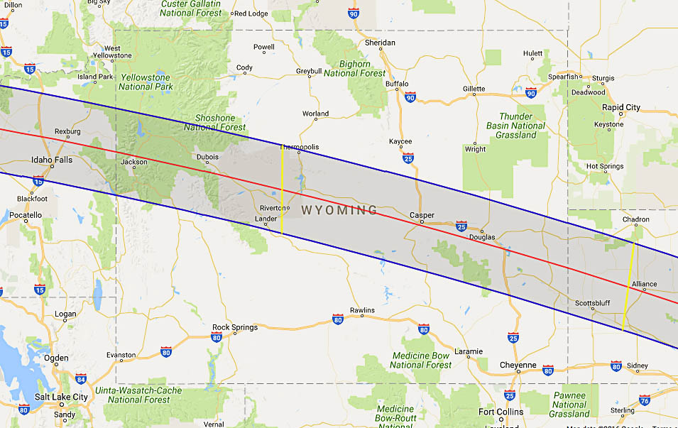
Google Map of 2017 Total Eclipse in Wyoming
(Click to use interactive map)
The map above links to an interactive Google map showing the visibility of the Total Solar Eclipse of 2017 Aug 21 in Wyoming. The interactive map allows the user to zoom and drag the map as desired. Click the cursor on any location to generate eclipse circumstances from that location.
Eclipse Circumstances for Cities in Wyoming
The table below lists eclipse circumstances for a number of cities in Wyoming. The following information is given for each city.
- The type of eclipse seen from the city (Partial or Total).
- The times when the partial eclipse begins and ends.
- The times when the total eclipse begins and ends.
- The time of maximum eclipse.
- The altitude on the Sun above the horizon (in degrees) at each of these times.
- The Eclipse Magnitude at maximum eclipse. Eclipse Magnitude is the fraction of the Sun’s diameter occulted by the Moon.
- The Eclipse Obscuration at maximum eclipse. Eclipse obscuration is the fraction of the Sun’s area occulted by the Moon.
- The Duration Total Eclipse is the length of the total phase in minutes and seconds (i.e., totality).
The times appearing in this table include Daylight Saving Time (DST) for all cities in which DST is observed. Report time zone or DST corrections for any city to EclipseWise.
Thanks to Bill Kramer (Eclipse-Chasers.com) for helping to develop the code to generate the above eclipse circumstances table. To calculate predictions for other cities see 2017 Eclipse Circumstances Calculator.
The partial phases require either a projection technique or a special solar filter to be viewed safely. On the other hand it is completely safe to watch Totality with the naked eye. For more information see Safe Solar Eclipse Viewing.
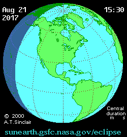
Animation of the Moon's Shadow Across Wyoming
The animation above shows the Moon's umbral shadow as it tracks across Wyoming. Observers must be inside this path to see the total eclipse. Outside the path only a partial eclipse is seen.
Animation courtesy of Michael Zeiler GreatAmericanEclipse.com.
States in the Path of Totality
The index below gives links to special pages for each of the 12 states in the path of the 2017 total solar eclipse. Note that the eclipse path also crosses a tiny corner of Montana and Iowa, but they are not included in this table.
| States in the Path of Totality | ||
Georgia |
Kentucky |
Oregon |
Idaho |
Missouri |
South Carolina |
Illinois |
Nebraska |
Tennessee |
Kansas |
North Carolina |
Wyoming |
Publications on the 2017 Total Solar Eclipse

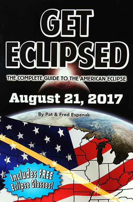
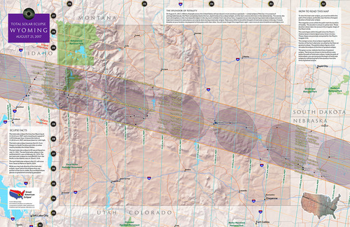
11" x 17" poster map of the 2017 eclipse path through Wyoming
(GreatAmericanEclipse.com)
Additional Links for the 2017 Total Solar Eclipse
- Prime Page: Total Solar Eclipse of 2017 Aug 21 - EclipseWise general information on the eclipse
- Special News Page: Total Solar Eclipse of 2017 Aug 21 - major resources and links for the eclipse
- Orthographic Map: Total Solar Eclipse of 2017 Aug 21 - detailed map of eclipse visibility
- Animated Map: Total Solar Eclipse of 2017 Aug 21 - animated map of the Moon's shadows across Earth
- Google Map: Total Solar Eclipse of 2017 Aug 21 - interactive map of the eclipse path
- Path Table: Total Solar Eclipse of 2017 Aug 21 - coordinates of the central line and path limits
- Circumstances Table: Total Solar Eclipse of 2017 Aug 21 - eclipse times for hundreds of cities
- Saros 145 Table - data for all eclipses in the Saros series
- Total Solar Eclipse of 2017 Aug 21 - Google search for links to this eclipse
- 2017 Eclipse - American Astronomical Society (AAS)
- 2017 Eclipse in Wyoming - GreatAmericanEclipse.com
- Detailed map of the 2017 eclipse path through Wyoming - GreatAmericanEclipse.com
- Eclipse Communities in Wyoming - Eclipse2017.org
- Eclipsophile.com - Weather for the 2017 Eclipse

Safe Solar Eclipse Glasses |

Rainbow Symphony Eclipse Shades |

Thousand Oaks Optical Solar Filters |

Great American Eclipse Store |
Links to Additional Solar Eclipse Information
- Home - home page of EclipseWise with predictions for both solar and lunar eclipses
- Solar Eclipses - primary page for solar eclipse predictions
- Solar Eclipse Links - detailed directory of links
- 21st Century Catalog of Solar Eclipses - including the years 2001 to 2100
- Total Solar Eclipses in the USA - maps for all total solar eclipses in the USA from 1001 to 3000
- Annular Solar Eclipses in the USA - maps for all annular solar eclipses in the USA from 1001 to 3000
- Hybrid Solar Eclipses in the USA - maps for all hybrid solar eclipses in the USA from 1001 to 3000
- Javascript Solar Eclipse Explorer - find all solar eclipses visible from a city
- MrEclipse.com - Eclipse resources and tips on photography
- Solar Eclipses for Beginners - a primer on solar eclipse basics
- Safe Solar Eclipse Viewing - summarizes several safe ways to view an eclipse of the Sun
- Solar Filter and Eclipse Glasses - a list of links
- Observing Solar Eclipses Safely - instructions for safely viewing an eclipse of the Sun
- How to Photograph a Solar Eclipse - instructions for imaging an eclipse of the Sun
- MrEclipse Photo Index - an index of solar eclipse photographs
Acknowledgments
Some in the JavaScript code used here is based on the work of Deirdre O'Byrne and Stephen McCann. Bill Kramer (Eclipse-Chasers.com) has expanded this code to work with dozens of cities.
The Besselian elements and values of ΔT used in these calculations are from Eclipse Bulletin: Total Solar Eclipse of 2017 August 21.
Permission is freely granted to reproduce this data when accompanied by an acknowledgment:
"Eclipse Predictions by Fred Espenak (EclipseWise.com)"