
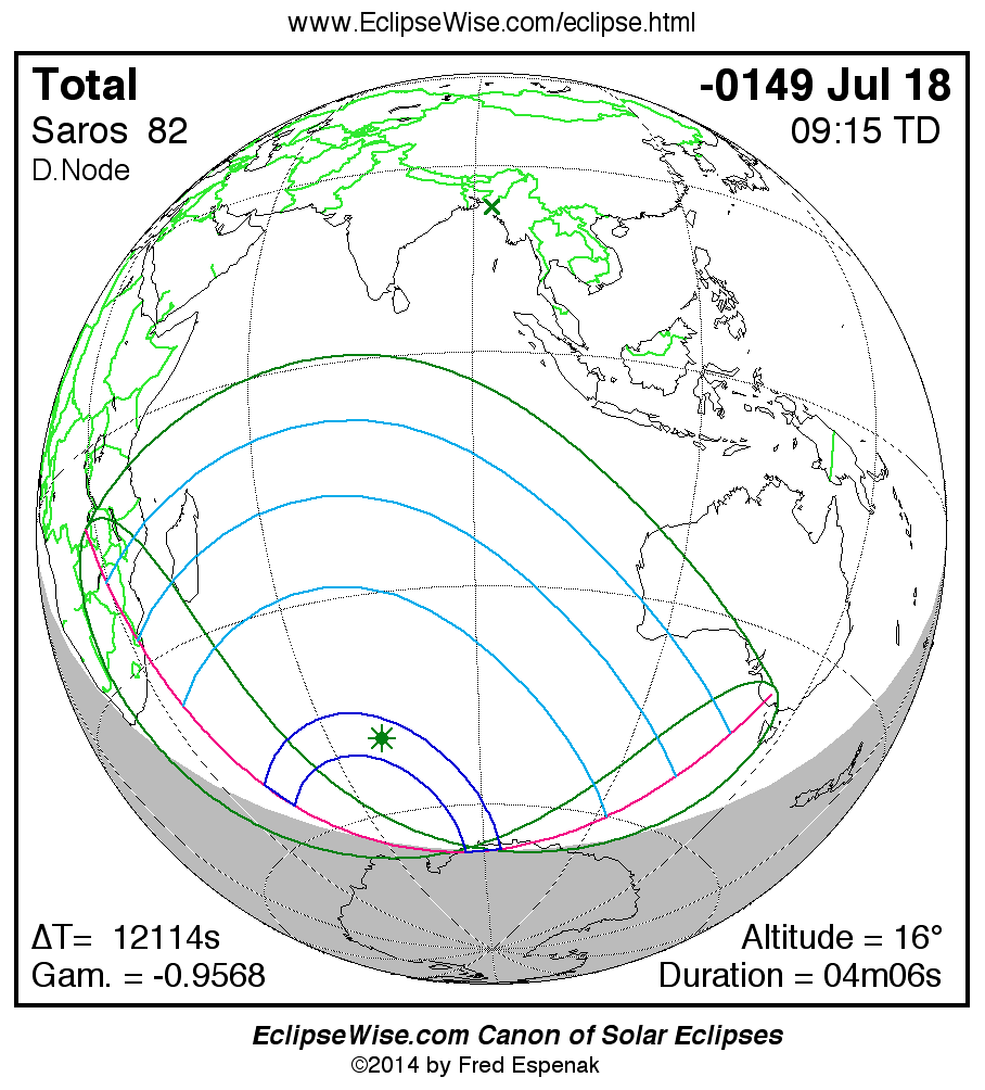
Path of the Total Solar Eclipse of -0149 Jul 18
Fred Espenak
Introduction
The following table delineates the path of the Moon's umbral shadow during the Total Solar Eclipse of -0149 Jul 18 . The geographic coordinates (WGS 84) of the northern and southern limits and the central line are listed at 120-second intervals. This provides adequate detail for making plots of the path on larger scale maps. Local circumstances on the central line include the ratio of the apparent diameters of the Moon to the Sun, the Sun's altitude and azimuth (degrees), the path width (kilometers) and the duration on the central line (minutes and seconds). See the Explanation of the Central Eclipse Path Table for a description of each column in the table.
The geographic visibility of the eclipse is shown on a global map on the Prime Page for the Eclipse which also includes complete details on the eclipse. The path of the eclipse is displayed in greater detail on an interactive Google Map .
| Total Solar Eclipse of -0149 Jul 18 | |||||||||||
| UT1 | Northern Limit | Southern Limit | Central Line | M:S | Sun | Sun | Path | Central | |||
| Latitude | Longitude | Latitude | Longitude | Latitude | Longitude | Ratio | Alt. | Azm. | Width | Duration | |
| Limits | 50°51.7'S | 040°29.5'E | 55°01.6'S | 043°45.7'E | 52°48.5'S | 041°52.5'E | 1.050 | 0° | - | 490 km | 03m12.6s |
| 05:24 | 46°11.6'S | 052°43.9'E | - | - | 51°08.4'S | 045°36.3'E | 1.051 | 3° | 48° | 508 km | 03m21.0s |
| 05:26 | 45°38.8'S | 055°00.1'E | - | - | 49°24.6'S | 050°21.4'E | 1.052 | 7° | 44° | 539 km | 03m32.2s |
| 05:28 | 45°16.7'S | 056°56.1'E | - | - | 48°36.0'S | 053°14.0'E | 1.053 | 9° | 42° | 562 km | 03m39.0s |
| 05:30 | 45°02.0'S | 058°38.9'E | 52°36.6'S | 049°38.7'E | 48°06.2'S | 055°29.8'E | 1.053 | 10° | 39° | 581 km | 03m44.3s |
| 05:32 | 44°52.9'S | 060°12.2'E | 51°37.9'S | 052°57.8'E | 47°47.3'S | 057°25.4'E | 1.054 | 11° | 37° | 598 km | 03m48.5s |
| 05:34 | 44°48.3'S | 061°38.5'E | 51°06.4'S | 055°24.0'E | 47°35.9'S | 059°08.0'E | 1.054 | 12° | 36° | 612 km | 03m52.1s |
| 05:36 | 44°47.5'S | 062°59.2'E | 50°48.3'S | 057°25.5'E | 47°30.1'S | 060°41.3'E | 1.054 | 13° | 34° | 625 km | 03m55.2s |
| 05:38 | 44°50.0'S | 064°15.5'E | 50°38.9'S | 059°12.1'E | 47°29.1'S | 062°07.8'E | 1.054 | 14° | 32° | 635 km | 03m57.8s |
| 05:40 | 44°55.5'S | 065°28.2'E | 50°36.1'S | 060°48.4'E | 47°31.9'S | 063°28.9'E | 1.055 | 15° | 30° | 642 km | 04m00.0s |
| 05:42 | 45°03.8'S | 066°38.0'E | 50°38.4'S | 062°17.3'E | 47°38.3'S | 064°45.8'E | 1.055 | 15° | 29° | 647 km | 04m01.8s |
| 05:44 | 45°14.6'S | 067°45.4'E | 50°45.3'S | 063°40.7'E | 47°47.8'S | 065°59.3'E | 1.055 | 16° | 27° | 650 km | 04m03.2s |
| 05:46 | 45°27.9'S | 068°50.9'E | 50°56.2'S | 064°59.7'E | 48°00.4'S | 067°10.1'E | 1.055 | 16° | 26° | 650 km | 04m04.4s |
| 05:48 | 45°43.6'S | 069°54.7'E | 51°10.7'S | 066°15.3'E | 48°15.8'S | 068°18.7'E | 1.055 | 16° | 24° | 648 km | 04m05.2s |
| 05:50 | 46°01.6'S | 070°57.3'E | 51°28.9'S | 067°28.3'E | 48°33.9'S | 069°25.6'E | 1.055 | 16° | 23° | 645 km | 04m05.7s |
| 05:52 | 46°21.9'S | 071°59.0'E | 51°50.5'S | 068°39.2'E | 48°54.8'S | 070°31.1'E | 1.055 | 16° | 21° | 639 km | 04m06.0s |
| 05:54 | 46°44.6'S | 072°59.9'E | 52°15.6'S | 069°48.6'E | 49°18.5'S | 071°35.7'E | 1.055 | 16° | 20° | 632 km | 04m05.9s |
| 05:56 | 47°09.7'S | 074°00.4'E | 52°44.3'S | 070°56.8'E | 49°45.0'S | 072°39.6'E | 1.055 | 16° | 18° | 624 km | 04m05.6s |
| 05:58 | 47°37.3'S | 075°00.7'E | 53°16.8'S | 072°04.4'E | 50°14.5'S | 073°43.2'E | 1.055 | 16° | 17° | 615 km | 04m04.9s |
| 06:00 | 48°07.5'S | 076°01.1'E | 53°53.5'S | 073°11.7'E | 50°47.2'S | 074°46.7'E | 1.055 | 16° | 15° | 605 km | 04m04.0s |
| 06:02 | 48°40.4'S | 077°01.9'E | 54°34.8'S | 074°19.0'E | 51°23.3'S | 075°50.6'E | 1.055 | 15° | 14° | 594 km | 04m02.8s |
| 06:04 | 49°16.3'S | 078°03.2'E | 55°21.4'S | 075°27.0'E | 52°03.1'S | 076°55.2'E | 1.055 | 15° | 12° | 583 km | 04m01.2s |
| 06:06 | 49°55.5'S | 079°05.6'E | 56°14.2'S | 076°36.0'E | 52°47.1'S | 078°00.8'E | 1.055 | 15° | 10° | 572 km | 03m59.3s |
| 06:08 | 50°38.4'S | 080°09.2'E | 57°14.7'S | 077°46.6'E | 53°35.9'S | 079°08.0'E | 1.055 | 14° | 9° | 561 km | 03m57.1s |
| 06:10 | 51°25.3'S | 081°14.6'E | 58°25.4'S | 078°59.6'E | 54°30.5'S | 080°17.3'E | 1.054 | 13° | 7° | 550 km | 03m54.4s |
| 06:12 | 52°17.0'S | 082°22.4'E | 59°50.5'S | 080°16.0'E | 55°32.1'S | 081°29.6'E | 1.054 | 12° | 6° | 539 km | 03m51.3s |
| 06:14 | 53°14.4'S | 083°33.2'E | 61°39.7'S | 081°37.2'E | 56°42.8'S | 082°45.9'E | 1.054 | 11° | 4° | 529 km | 03m47.6s |
| 06:16 | 54°18.9'S | 084°48.0'E | 64°26.5'S | 083°05.3'E | 58°05.9'S | 084°07.9'E | 1.053 | 10° | 2° | 519 km | 03m43.1s |
| 06:18 | 55°32.3'S | 086°08.3'E | - | - | 59°48.3'S | 085°38.5'E | 1.053 | 8° | 0° | 510 km | 03m37.7s |
| 06:20 | 56°58.2'S | 087°36.3'E | - | - | 62°07.4'S | 087°24.5'E | 1.052 | 6° | 358° | 501 km | 03m30.4s |
| Limits | 67°29.5'S | 095°30.7'E | 67°53.4'S | 083°42.7'E | 67°49.6'S | 090°08.2'E | 1.050 | 0° | - | 496 km | 03m13.4s |
ΔT = 12112.4 seconds
| Greatest Eclipse and Greatest Duration | ||||||||
| Event | Time TD |
Time UT1 |
Latitude | Longitude | Sun Altitude |
Sun Azimuth |
Path Width | Central Duration |
| Greatest Eclipse | 09:14:44.4 | 05:52:51.9 | 49°04.7'S | 020°22.8'E | 16.4° | 20.4° | 636.3 km | 04m05.98s |
| Greatest Duration | 09:14:30.9 | 05:52:38.5 | 49°02.1'S | 070°51.9'E | 16.4° | 20.6° | 637.0 km | 04m05.98s |
Links for the Total Solar Eclipse of -0149 Jul 18
Links to Additional Solar Eclipse Predictions
- Home - home page of EclipseWise with predictions for both solar and lunar eclipses
- Solar Eclipses - primary page for solar eclipse predictions
- Solar Eclipse Links - detailed directory of links
Eclipse Predictions
Predictions for the Total Solar Eclipse of -0149 Jul 18 were generated using the JPL DE406 solar and lunar ephemerides. The lunar coordinates were calculated with respect to the Moon's Center of Mass. Although the predictions are first calculated in Terrestrial Dynamical Time (TD), they are then converted to Universal Time (UT1) as presented here. The parameter ΔT is used to convert between the two times (i.e., UT1 = TD - ΔT). ΔT has a value of 12112.4 seconds for this eclipse. The uncertainty in ΔT is 310.0 seconds corresponding to a standard error in longitude of the eclipse path of ± 1.30°.
Acknowledgments
All eclipse calculations are by Fred Espenak, and he assumes full responsibility for their accuracy.
Permission is granted to reproduce eclipse data when accompanied by a link to this page and an acknowledgment:
"Eclipse Predictions by Fred Espenak, EclipseWise.com"
The use of diagrams and maps is permitted provided that they are unaltered (except for re-sizing) and the embedded credit line is not removed or covered.