
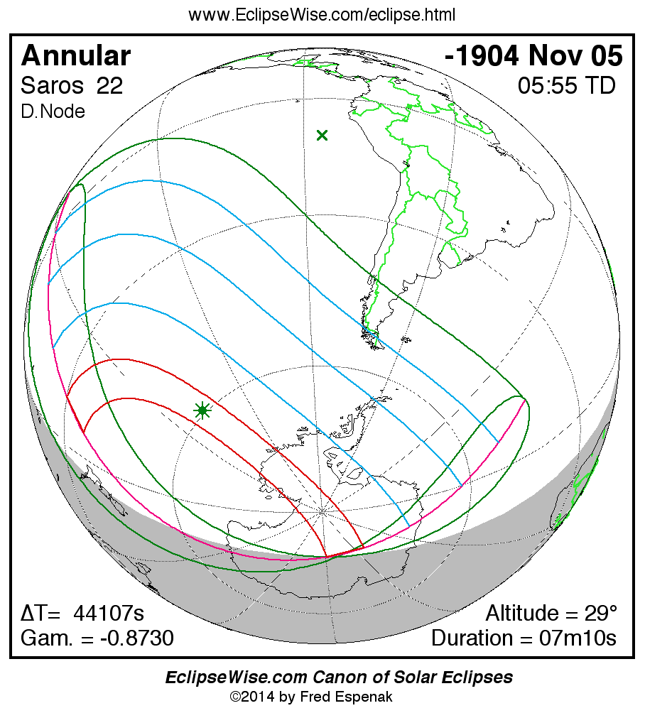
Path of the Annular Solar Eclipse of -1904 Nov 06
Fred Espenak
Introduction
The following table delineates the path of the Moon's antumbral shadow during the Annular Solar Eclipse of -1904 Nov 06 . The geographic coordinates (WGS 84) of the northern and southern limits and the central line are listed at 120-second intervals. This provides adequate detail for making plots of the path on larger scale maps. Local circumstances on the central line include the ratio of the apparent diameters of the Moon to the Sun, the Sun's altitude and azimuth (degrees), the path width (kilometers) and the duration on the central line (minutes and seconds). See the Explanation of the Central Eclipse Path Table for a description of each column in the table.
The geographic visibility of the eclipse is shown on a global map on the Prime Page for the Eclipse which also includes complete details on the eclipse. The path of the eclipse is displayed in greater detail on an interactive Google Map .
| Annular Solar Eclipse of -1904 Nov 06 | |||||||||||
| UT1 | Northern Limit | Southern Limit | Central Line | M:S | Sun | Sun | Path | Central | |||
| Latitude | Longitude | Latitude | Longitude | Latitude | Longitude | Ratio | Alt. | Azm. | Width | Duration | |
| Limits | 30°12.8'S | 167°49.6'W | 36°53.8'S | 172°56.9'W | 33°22.6'S | 170°11.5'W | 0.905 | 0° | - | 822 km | 06m16.2s |
| 16:44 | 35°29.3'S | 153°24.2'W | - | - | 35°07.3'S | 163°37.8'W | 0.906 | 6° | 100° | 846 km | 06m25.8s |
| 16:46 | 36°26.5'S | 151°48.3'W | - | - | 36°27.7'S | 160°08.5'W | 0.907 | 9° | 97° | 856 km | 06m31.6s |
| 16:48 | 37°21.1'S | 150°25.0'W | - | - | 37°34.6'S | 157°46.4'W | 0.908 | 12° | 95° | 859 km | 06m35.8s |
| 16:50 | 38°13.9'S | 149°11.1'W | 37°54.0'S | 168°40.4'W | 38°35.5'S | 155°54.7'W | 0.908 | 14° | 94° | 859 km | 06m39.3s |
| 16:52 | 39°05.1'S | 148°04.4'W | 39°26.5'S | 164°08.6'W | 39°32.8'S | 154°21.2'W | 0.909 | 15° | 92° | 856 km | 06m42.3s |
| 16:54 | 39°55.3'S | 147°03.4'W | 40°36.8'S | 161°31.5'W | 40°27.6'S | 153°00.2'W | 0.909 | 17° | 91° | 852 km | 06m45.0s |
| 16:56 | 40°44.5'S | 146°07.2'W | 41°39.6'S | 159°33.4'W | 41°20.7'S | 151°48.4'W | 0.909 | 18° | 89° | 846 km | 06m47.4s |
| 16:58 | 41°33.0'S | 145°14.9'W | 42°38.4'S | 157°56.9'W | 42°12.5'S | 150°43.7'W | 0.910 | 19° | 88° | 839 km | 06m49.6s |
| 17:00 | 42°20.9'S | 144°25.9'W | 43°34.7'S | 156°34.7'W | 43°03.3'S | 149°44.8'W | 0.910 | 20° | 87° | 832 km | 06m51.6s |
| 17:02 | 43°08.4'S | 143°39.8'W | 44°29.1'S | 155°22.8'W | 43°53.3'S | 148°50.5'W | 0.910 | 21° | 85° | 823 km | 06m53.4s |
| 17:04 | 43°55.4'S | 142°56.1'W | 45°22.2'S | 154°18.7'W | 44°42.7'S | 148°00.2'W | 0.910 | 22° | 84° | 815 km | 06m55.2s |
| 17:06 | 44°42.2'S | 142°14.6'W | 46°14.4'S | 153°20.8'W | 45°31.6'S | 147°13.2'W | 0.910 | 23° | 83° | 806 km | 06m56.8s |
| 17:08 | 45°28.6'S | 141°34.9'W | 47°05.8'S | 152°28.1'W | 46°20.1'S | 146°29.1'W | 0.911 | 24° | 81° | 797 km | 06m58.2s |
| 17:10 | 46°14.9'S | 140°56.9'W | 47°56.7'S | 151°39.6'W | 47°08.3'S | 145°47.5'W | 0.911 | 24° | 80° | 788 km | 06m59.6s |
| 17:12 | 47°01.1'S | 140°20.4'W | 48°47.2'S | 150°54.8'W | 47°56.3'S | 145°08.1'W | 0.911 | 25° | 79° | 779 km | 07m00.9s |
| 17:14 | 47°47.1'S | 139°45.1'W | 49°37.4'S | 150°13.1'W | 48°44.1'S | 144°30.6'W | 0.911 | 25° | 78° | 770 km | 07m02.0s |
| 17:16 | 48°33.1'S | 139°10.9'W | 50°27.4'S | 149°34.2'W | 49°31.9'S | 143°54.8'W | 0.911 | 26° | 76° | 762 km | 07m03.1s |
| 17:18 | 49°19.0'S | 138°37.7'W | 51°17.2'S | 148°57.8'W | 50°19.6'S | 143°20.5'W | 0.911 | 26° | 75° | 753 km | 07m04.1s |
| 17:20 | 50°05.0'S | 138°05.3'W | 52°07.1'S | 148°23.6'W | 51°07.4'S | 142°47.6'W | 0.911 | 27° | 74° | 745 km | 07m05.0s |
| 17:22 | 50°51.1'S | 137°33.6'W | 52°56.9'S | 147°51.4'W | 51°55.1'S | 142°15.8'W | 0.911 | 27° | 72° | 737 km | 07m05.9s |
| 17:24 | 51°37.2'S | 137°02.6'W | 53°46.8'S | 147°20.9'W | 52°43.0'S | 141°45.1'W | 0.912 | 28° | 71° | 730 km | 07m06.6s |
| 17:26 | 52°23.4'S | 136°32.1'W | 54°36.9'S | 146°52.2'W | 53°31.1'S | 141°15.4'W | 0.912 | 28° | 70° | 723 km | 07m07.3s |
| 17:28 | 53°09.8'S | 136°02.0'W | 55°27.1'S | 146°24.9'W | 54°19.3'S | 140°46.5'W | 0.912 | 28° | 68° | 716 km | 07m07.8s |
| 17:30 | 53°56.4'S | 135°32.2'W | 56°17.6'S | 145°59.1'W | 55°07.7'S | 140°18.4'W | 0.912 | 28° | 67° | 709 km | 07m08.4s |
| 17:32 | 54°43.1'S | 135°02.7'W | 57°08.4'S | 145°34.7'W | 55°56.4'S | 139°50.9'W | 0.912 | 29° | 66° | 703 km | 07m08.8s |
| 17:34 | 55°30.2'S | 134°33.3'W | 57°59.5'S | 145°11.5'W | 56°45.3'S | 139°23.9'W | 0.912 | 29° | 65° | 697 km | 07m09.1s |
| 17:36 | 56°17.4'S | 134°03.9'W | 58°51.0'S | 144°49.5'W | 57°34.7'S | 138°57.5'W | 0.912 | 29° | 63° | 691 km | 07m09.4s |
| 17:38 | 57°05.0'S | 133°34.5'W | 59°43.0'S | 144°28.8'W | 58°24.3'S | 138°31.5'W | 0.912 | 29° | 62° | 686 km | 07m09.6s |
| 17:40 | 57°53.0'S | 133°04.9'W | 60°35.5'S | 144°09.2'W | 59°14.5'S | 138°05.8'W | 0.912 | 29° | 61° | 682 km | 07m09.8s |
| 17:42 | 58°41.3'S | 132°35.1'W | 61°28.5'S | 143°50.8'W | 60°05.0'S | 137°40.4'W | 0.912 | 29° | 59° | 677 km | 07m09.8s |
| 17:44 | 59°30.0'S | 132°05.0'W | 62°22.1'S | 143°33.6'W | 60°56.1'S | 137°15.1'W | 0.912 | 29° | 58° | 673 km | 07m09.8s |
| 17:46 | 60°19.1'S | 131°34.4'W | 63°16.4'S | 143°17.6'W | 61°47.8'S | 136°50.1'W | 0.912 | 29° | 57° | 669 km | 07m09.7s |
| 17:48 | 61°08.7'S | 131°03.2'W | 64°11.5'S | 143°02.9'W | 62°40.0'S | 136°25.0'W | 0.912 | 29° | 55° | 666 km | 07m09.5s |
| 17:50 | 61°58.9'S | 130°31.4'W | 65°07.4'S | 142°49.6'W | 63°33.0'S | 136°00.0'W | 0.912 | 28° | 54° | 663 km | 07m09.2s |
| 17:52 | 62°49.6'S | 129°58.7'W | 66°04.2'S | 142°37.8'W | 64°26.6'S | 135°34.9'W | 0.912 | 28° | 53° | 661 km | 07m08.9s |
| 17:54 | 63°41.0'S | 129°24.9'W | 67°02.0'S | 142°27.8'W | 65°21.1'S | 135°09.7'W | 0.912 | 28° | 51° | 659 km | 07m08.4s |
| 17:56 | 64°33.0'S | 128°50.1'W | 68°00.8'S | 142°19.7'W | 66°16.4'S | 134°44.3'W | 0.912 | 28° | 50° | 657 km | 07m07.9s |
| 17:58 | 65°25.7'S | 128°13.8'W | 69°00.9'S | 142°13.9'W | 67°12.7'S | 134°18.6'W | 0.912 | 27° | 49° | 656 km | 07m07.3s |
| 18:00 | 66°19.2'S | 127°35.8'W | 70°02.3'S | 142°10.8'W | 68°10.1'S | 133°52.5'W | 0.911 | 27° | 47° | 655 km | 07m06.6s |
| 18:02 | 67°13.6'S | 126°56.0'W | 71°05.2'S | 142°11.2'W | 69°08.6'S | 133°25.9'W | 0.911 | 26° | 46° | 654 km | 07m05.8s |
| 18:04 | 68°08.9'S | 126°14.0'W | 72°09.6'S | 142°15.7'W | 70°08.3'S | 132°58.9'W | 0.911 | 26° | 44° | 654 km | 07m04.9s |
| 18:06 | 69°05.2'S | 125°29.3'W | 73°15.9'S | 142°25.6'W | 71°09.5'S | 132°31.1'W | 0.911 | 25° | 43° | 655 km | 07m03.9s |
| 18:08 | 70°02.6'S | 124°41.5'W | 74°24.2'S | 142°42.7'W | 72°12.2'S | 132°02.7'W | 0.911 | 25° | 42° | 656 km | 07m02.8s |
| 18:10 | 71°01.3'S | 123°49.9'W | 75°34.8'S | 143°09.3'W | 73°16.7'S | 131°33.4'W | 0.911 | 24° | 40° | 657 km | 07m01.6s |
| 18:12 | 72°01.2'S | 122°54.0'W | 76°47.9'S | 143°49.4'W | 74°23.1'S | 131°03.2'W | 0.911 | 24° | 39° | 659 km | 07m00.2s |
| 18:14 | 73°02.6'S | 121°52.5'W | 78°03.9'S | 144°49.0'W | 75°31.7'S | 130°31.9'W | 0.911 | 23° | 38° | 662 km | 06m58.8s |
| 18:16 | 74°05.6'S | 120°44.3'W | 79°23.0'S | 146°18.1'W | 76°42.8'S | 129°59.5'W | 0.910 | 22° | 36° | 665 km | 06m57.2s |
| 18:18 | 75°10.4'S | 119°27.6'W | 80°45.6'S | 148°35.0'W | 77°56.8'S | 129°26.0'W | 0.910 | 21° | 35° | 669 km | 06m55.4s |
| 18:20 | 76°17.2'S | 117°59.9'W | 82°11.6'S | 152°14.8'W | 79°14.2'S | 128°51.2'W | 0.910 | 20° | 33° | 674 km | 06m53.5s |
| 18:22 | 77°26.2'S | 116°17.8'W | 83°40.2'S | 158°33.6'W | 80°35.6'S | 128°15.7'W | 0.910 | 19° | 32° | 680 km | 06m51.4s |
| 18:24 | 78°37.6'S | 114°15.9'W | 85°06.4'S | 170°34.1'W | 82°01.8'S | 127°40.1'W | 0.909 | 18° | 31° | 687 km | 06m49.1s |
| 18:26 | 79°51.7'S | 111°45.8'W | 86°10.5'S | 164°56.3'E | 83°34.0'S | 127°06.9'W | 0.909 | 17° | 29° | 695 km | 06m46.6s |
| 18:28 | 81°08.8'S | 108°33.2'W | 85°54.2'S | 126°40.0'E | 85°13.8'S | 126°44.1'W | 0.909 | 15° | 28° | 704 km | 06m43.8s |
| 18:30 | 82°29.1'S | 104°11.5'W | 83°03.7'S | 097°45.8'E | 87°03.8'S | 127°05.9'W | 0.908 | 14° | 28° | 716 km | 06m40.6s |
| 18:32 | 83°52.0'S | 097°47.0'W | - | - | 89°07.8'S | 135°14.6'W | 0.908 | 12° | 35° | 730 km | 06m36.9s |
| 18:34 | 85°15.7'S | 087°14.0'W | - | - | 88°21.0'S | 067°02.8'E | 0.907 | 10° | 192° | 749 km | 06m32.4s |
| 18:36 | 86°31.0'S | 067°13.5'W | - | - | 85°01.9'S | 064°50.1'E | 0.907 | 6° | 194° | 776 km | 06m26.4s |
| Limits | 77°40.2'S | 052°26.6'E | 78°38.3'S | 089°02.1'E | 78°36.6'S | 069°00.3'E | 0.905 | 0° | - | 829 km | 06m15.0s |
ΔT = 44102.0 seconds
| Greatest Eclipse and Greatest Duration | ||||||||
| Event | Time TD |
Time UT1 |
Latitude | Longitude | Sun Altitude |
Sun Azimuth |
Path Width | Central Duration |
| Greatest Eclipse | 05:55:25.4 | 17:40:23.4 | 59°24.3'S | 037°43.5'E | 28.8° | 60.3° | 680.7 km | 07m09.77s |
| Greatest Duration | 05:57:16.5 | 17:42:14.5 | 60°11.2'S | 137°37.3'W | 28.8° | 59.1° | 676.6 km | 07m09.80s |
Links for the Annular Solar Eclipse of -1904 Nov 06
Links to Additional Solar Eclipse Predictions
- Home - home page of EclipseWise with predictions for both solar and lunar eclipses
- Solar Eclipses - primary page for solar eclipse predictions
- Solar Eclipse Links - detailed directory of links
Eclipse Predictions
Predictions for the Annular Solar Eclipse of -1904 Nov 06 were generated using the JPL DE406 solar and lunar ephemerides. The lunar coordinates were calculated with respect to the Moon's Center of Mass. Although the predictions are first calculated in Terrestrial Dynamical Time (TD), they are then converted to Universal Time (UT1) as presented here. The parameter ΔT is used to convert between the two times (i.e., UT1 = TD - ΔT). ΔT has a value of 44102.0 seconds for this eclipse. The uncertainty in ΔT is 3335.2 seconds corresponding to a standard error in longitude of the eclipse path of ± 13.93°.
Acknowledgments
All eclipse calculations are by Fred Espenak, and he assumes full responsibility for their accuracy.
Permission is granted to reproduce eclipse data when accompanied by a link to this page and an acknowledgment:
"Eclipse Predictions by Fred Espenak, EclipseWise.com"
The use of diagrams and maps is permitted provided that they are unaltered (except for re-sizing) and the embedded credit line is not removed or covered.