
Eclipses During 2019
By Fred Espenak
Based on the Article Published in
Observer's Handbook
2019
,
Royal Astronomical Society of Canada
In 2019, there are three solar eclipses and two lunar eclipses:
| Eclipses During 2019 | |||
| 2019 Jan 06: Partial Solar Eclipse | |||
| 2019 Jan 21: Total Lunar Eclipse | |||
| 2019 Jul 02: Total Solar Eclipse | |||
| 2019 Jul 16: Partial Lunar Eclipse | |||
| 2019 Dec 26: Annular Solar Eclipse | |||
| Eclipses During 2019 | ||||
|
Partial Solar Eclipse 2019 Jan 06 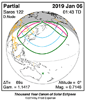
|
Total Lunar Eclipse 2019 Jan 21 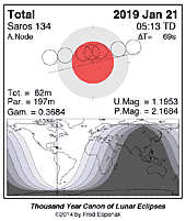
|
Total Solar Eclipse 2019 Jul 02 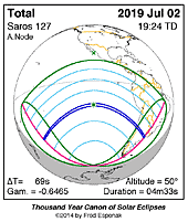
|
Partial Lunar Eclipse 2019 Jul 16 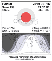
|
Annular Solar Eclipse 2019 Dec 26 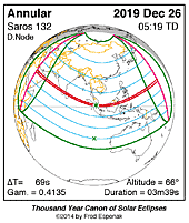
|
Predictions for the eclipses are summarized in Figures 1, 2, 3, 4, 5, and 6. World maps show the regions of visibility for each eclipse. The lunar eclipse diagrams also include the path of the Moon through Earth's shadow. Contact times for each principal phase are tabulated along with the magnitudes and geocentric coordinates of the Sun and Moon at greatest eclipse.
Unless otherwise stated, all times and dates used in this publication are in Universal Time or UT1. This astronomically derived time system is colloquially referred to as Greenwich Mean Time or GMT. To learn more about UT1 and how to convert UT1 to your own local time, see Time Zones and Universal Time.
Click for larger more detailed figure
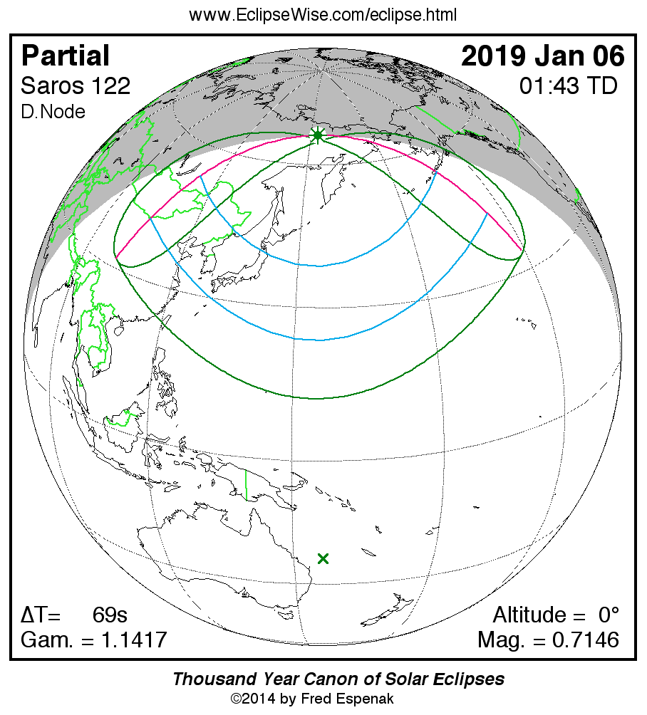
Partial Solar Eclipse of 2019 Jan 06
The first solar eclipse of 2019 occurs in Sagittarius at the Moon’s descending node. It is a Northern Hemisphere event and is visible from northeastern Asia and Alaska’s Aleutian Islands (Figure 1). At greatest eclipse [5] (01:41:29 UT1[2]), the eclipse magnitude [6] is 0.7146. This is 3.1 days before the Moon reaches apogee.
Local circumstances and eclipse times for a number of cities in Asia appear in Table 1. All times are given in Local Time.
This event is the 58th eclipse of Saros 122. The entire series of 70 eclipses spans the years 0991 through 2235. Only 3 members of this series were total (in the years 1135, 1153, and 1171). Saros 122 also has 2 hybrid, 37 annular, and 28 partial eclipses. Complete details for the series can be found at: Saros 122 .
For additional details on this event, see the EclipseWise Prime Page on the Partial Solar Eclipse of 2019 January 06.
Click for larger more detailed figure
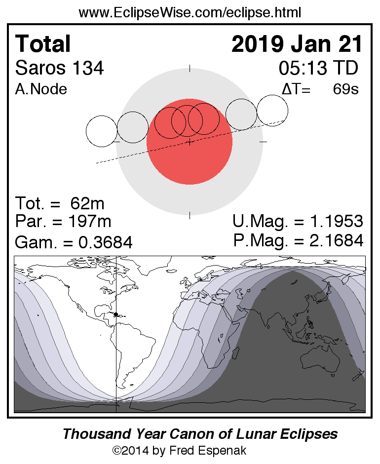
Total Lunar Eclipse of 2019 Jan 21
The first lunar eclipse of the year occurs at the Moon’s ascending node in Cancer. The apparent diameter of the Moon is larger than average since the eclipse occurs 0.6 days before (Jan 21 at 19:58 UT1). This is the last of three consecutive total lunar eclipses in 2018 and 2019, each one separated by six months (previous total lunar eclipses occurred on 2018 Jan 31 and Jul 27).
The Moon's orbital trajectory takes it through the northern half of Earth’s umbral shadow. In this particular case, the Moon passes deeply into the umbral shadow leading to a relatively long total eclipse lasting 1 hour 2 minutes.
The Moon’s path through Earth’s shadow and a map illustrating worldwide visibility of the event are shown in Figure 2. The times of the major eclipse phases are listed as follows.
                              Penumbral Eclipse Begins:     02:36:29 UT1
                              Partial Eclipse Begins:       03:33:55 UT1
                              Total Eclipse Begins:         04:41:19 UT1
                              Greatest Eclipse:             05:12:18 UT1
                              Total Eclipse Ends:           05:43:18 UT1
                              Partial Eclipse Ends:         06:50:42 UT1
                              Penumbral Eclipse Ends:       07:48:06 UT1
At the instant of greatest eclipse [1] (05:13:27 UT1) the Moon lies at the zenith for a point near eastern Cuba. The umbral eclipse magnitude [3] peaks at 1.1953 as the Moon’s southern limb passes 5.9 arc-minutes south of the umbra’s central axis.
In contrast, the Moon’s northern limb lies 6.5 arc-minutes from the edge of the shadow. As a result, the southern half of the Moon will appear much darker than the northern half because the Moon samples a large range of umbral depths during the total phase. The exact brightness distribution in the umbra is difficult to predict, so observers are encouraged to estimate the Danjon value at mid-totality (see Danjon Scale of Lunar Eclipse Brightness). It may also be necessary to assign different Danjon values to different portions of the Moon (e.g., north vs. south).
During totality, the winter/spring constellations are well placed for viewing so a number of bright stars can be used for magnitude comparisons. Procyon (m = +0.40) is 17° to the southwest of the eclipsed Moon, while Pollux (m = +1.40) and Castor (m = +1.58) are 10° and 14°, respectively, northwest, and Regulus (m = +1.40) is 28° east.
The entire event is visible from North and South America, the eastern Pacific Ocean, and westernmost Europe. Much of the eclipse will be seen in central and eastern Europe, but observers there will miss the later stages of the eclipse because they occur after moonset. Likewise parts of the central Pacific experience moonrise after the eclipse begins. None of the eclipse is visible from Central and South Asia, nor Indonesia, Australia or New Zealand.
Table 2 lists predicted umbral immersion and emersion times for 25 well-defined lunar craters. The timing of craters is useful in determining the atmospheric enlargement of Earth's shadow (see Crater Timings During Lunar Eclipses).
The January 21 eclipse is the 27th eclipse of Saros 134. This series began on 1150 Apr 01 and is composed of 72 lunar eclipses in the following sequence: 8 penumbral, 10 partial, 26 total, 10 partial, and 18 penumbral eclipses (Espenak and Meeus, 2009a). In this context, the January 21 eclipse is the 9th total eclipse in the series. The last total eclipse is on 2325 Jul 26 and the final eclipse of the series is on 2830 May 28. Complete details for this Saros series can be found at: Saros 134 .
For more information about this eclipse, see the EclipseWise Prime Page on the Total Lunar Eclipse of 2019 January 21.
Click for larger more detailed figure
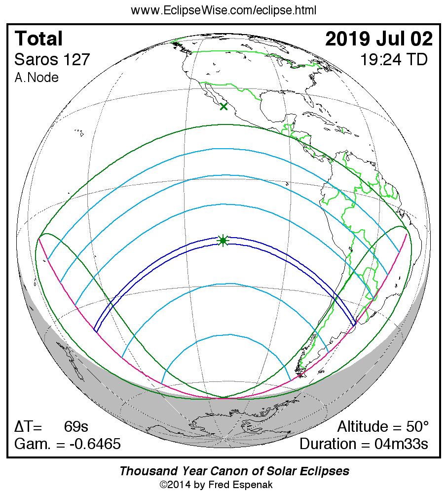
Total Solar Eclipse of 2019 Jul 02
The eagerly awaited total solar eclipse of July 02 is the first one since the Great American Total Eclipse of 2017. It occurs in Gemini at the Moon’s ascending node 2.4 days after the Moon reaches perigee. Such a close Moon during a total eclipse typically produces a long duration of totality - especially if the path passes near the Equator. In the case of the July 02 event, the maximum duration is just over 4.5 minutes.
The total eclipse is visible from within a narrow corridor that traverses the Pacific Ocean and southern South America. A partial eclipse is seen within the much broader path of the Moon's penumbral shadow, which includes the Pacific Ocean and most of South America (Figure 3).
The central path begins in the Pacific Ocean about 1900 kilometers east of New Zealand’s North Island at 18:02 UT1. The Moon’s umbral shadow makes first landfall at Oeno Island at 18:24 UT1 and lasts 2 minutes 53 seconds with the Sun at an altitude of 32°. Oeno Island is a remote coral atoll and is part of the Pitcairn Islands.
Unfortunately, there is no other landfall along the entirety of the Pacific track of 9500 kilometers. Greatest eclipse occurs at 19:24:08 UT1 in the South Pacific about 1080 kilometers north of Easter Island. The central duration of totality is 4 minutes 33 seconds, the Sun’s altitude is 50°, and the path width is 201 kilometers. The remaining 4,000+ kilometers of the path’s course to South America is across open ocean.
The path of totality finally reaches the coast of Chile at 20:39 UT1 50 kilometers north of La Serena (Figure 4). The central line duration is 2 minutes 36 seconds, the Sun’s altitude is 14°, the path width is 145 kilometers. La Serena itself is in the path where it’s citizens and visitors will experience a total eclipse lasting 2 minutes 17 seconds.
The shadow’s trajectory takes it on a southeastern course where it envelops the Elqui Valley, a 140-kilometer-long valley stretching from the Pacific Ocean eastward into the Andean foothills. The region enjoys especially dry and clear weather - so much so that a string of major international astronomical observatories have been built there, including Cerro Tololo, La Silla and Gemini South. It’s no surprise then that the Elqui Valley is the focus of many 2019 eclipse expeditions.
After crossing the Andes, the lunar shadow descends into Argentina for the last segment of its track. Here, the ground speed of the umbra increases rapidly as the Sun’s altitude sinks below 10°. The shadow covers the 1300-kilometer-stretch across Argentina in only 3 minutes. That’s an average speed of 26,000 kilometers per hour (16,000 mph)!
In Argentina, San Juan lies just inside the southern limit while Cordoba is 75 kilometers north of the track. Both cities will be popular destinations to mount short excursions to the eclipse path’s central line where totality still exceeds 2 minutes.
Just before the path ends, it barely misses Buenos Aires, the northern edge only 30 kilometers south of the center of the capital. The Sun will only be 1° above the horizon during 2 minutes of totality, so very clear weather conditions will be needed. Nevertheless, all roads leading from Buenos Aires to the central line will probably be clogged with traffic on eclipse day.
At 20:43 UT1 the lunar shadow lifts off Earth and returns to space. In the course of its 2 hour 41 minute trajectory, the umbra’s track is approximately 11,200 kilometers long and covers 0.36% of Earth’s surface. Central line coordinates and circumstances are presented in Table 3.
Partial phases of the eclipse are visible across the southern Pacific Ocean and South America. Local circumstances for a number of cities in South America are found in Table 4. All times are given in Local Time (or Daylight Saving Time when applicable). The Sun's altitude and azimuth, the eclipse magnitude and obscuration are all given at the instant of maximum eclipse at each location.
The 2019 Jul 02 Solar Eclipse Circumstances Calculator is an interactive web page that can quickly calculate the local circumstances for the eclipse from any geographic location not included in Table 4.
This is the 58th eclipse of Saros 127 (Espenak and Meeus, 2006). All eclipses in the series occur at the Moon's ascending node and gamma decreases with each member in the family. The series is a mature one that began with a modest partial eclipse on 0991 Oct 10. After 20 partial eclipses in the series and more than 3 centuries, the first umbral eclipse occurred on 1352 May 14. The event was a 2-minute total eclipse through New England, eastern Canada and Greenland. During the next 2 centuries, the umbral duration continued to increase as each path shifted progressively southward. The greatest umbral duration of Saros 127 occurred during the total eclipse of 1532 Aug 30. Unfortunately, the 5 minute 40 second total eclipse was only visible from equatorial Africa, which was virtually inaccessible to astronomers of the day.
As the duration of each succeeding eclipse decreased, the paths reversed their southern migration and drifted northward during the 18th and 19th centuries. This effect occurred as a result of the Northern Hemisphere season shifting from winter to summer when the Northern Hemisphere tipped towards the Sun.
The southbound trend of the Saros series resumed with the eclipse of 1947 May 20. At this point, the duration of totality at greatest eclipse had again increased to over 5 minutes. The most recent member occurred on 2001 Jun 21 and its path crossed southern Africa on the summer solstice. After 2019, the next member occurs on 2037 Jul 13 and passes through Australia and New Zealand. On 2055 Jul 24, the series returns to the African continent producing a path through South Africa. The duration of totality drops as Saros 127 continues to produce total eclipses during the 21st century. The last total eclipse of the series occurs on 2091 Aug 15 and lasts a maximum of 1 minute 38 seconds. The final 20 eclipses of the series are all partial events in the polar regions of the Southern Hemisphere. The family terminates with the partial eclipse of 2416 Feb 29. Complete details for the series can be found at: Saros 127.
For additional details on this event, see the EclipseWise Prime Page on the Total Solar Eclipse of 2019 July 02.
Click for larger more detailed figure
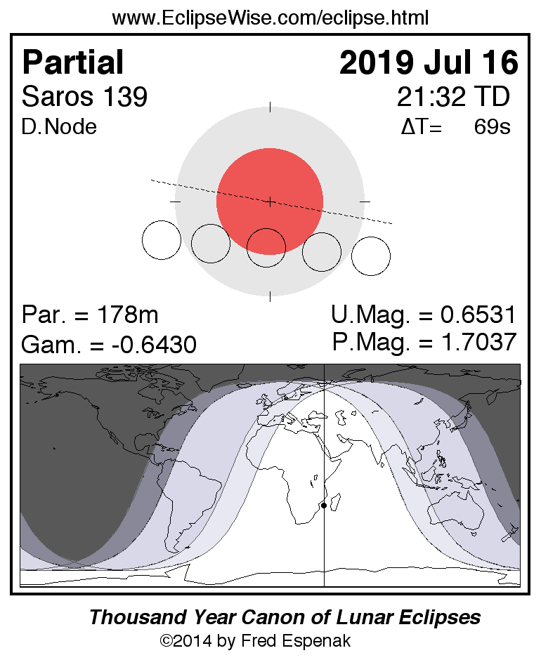
Partial Lunar Eclipse of 2019 Jul 16
The second lunar eclipse of 2019 occurs at the Moon’s descending node in Sagittarius. It takes place 4.1 days before the Moon reaches apogee (Jul 21 00:01 UT1) so the Moon’s apparent size (29’ 57”) is near its minimum.
The Moon’s path through Earth’s shadow and a map illustrating worldwide visibility of the event are shown in Figure 5. The times of the major eclipse phases are listed as follows.
                              Penumbral Eclipse Begins:     18:43:52 UT1
                              Partial Eclipse Begins:       20:01:44 UT1
                              Greatest Eclipse:             21:30:46 UT1
                              Partial Eclipse Ends:         22:59:42 UT1
                              Penumbral Eclipse Ends:       00:17:41 UT1
At the instant of greatest eclipse (21:30:46 UT1) the Moon lies near the zenith from a location in South Africa. The event is well placed for observers in Europe, Africa, and South Asia. None of the eclipse will be visible from North America. South America will see later stages of the eclipse, which begins before the Moon rises.
Table 5 lists predicted umbral immersion and emersion times for 25 well-defined lunar craters. The timing of craters is useful in determining the atmospheric enlargement of Earth’s shadow (see Crater Timings During Lunar Eclipses).
The July 16 eclipse is the 21st eclipse of Saros 139. This series began on 1658 Dec 09 and is composed of 79 lunar eclipses in the following sequence: 16 penumbral, 7 partial, 27 total, 8 partial, and 21 penumbral eclipses (Espenak and Meeus, 2009a). The first total eclipse is on 2073 Aug 17 and the final eclipse of the series is on 3065 Apr 13. Complete details for the series can be found at: Saros 139 .
For additional details on this event, see the EclipseWise Prime Page on the Partial Lunar Eclipse of 2019 July 16.
Click for larger more detailed figure
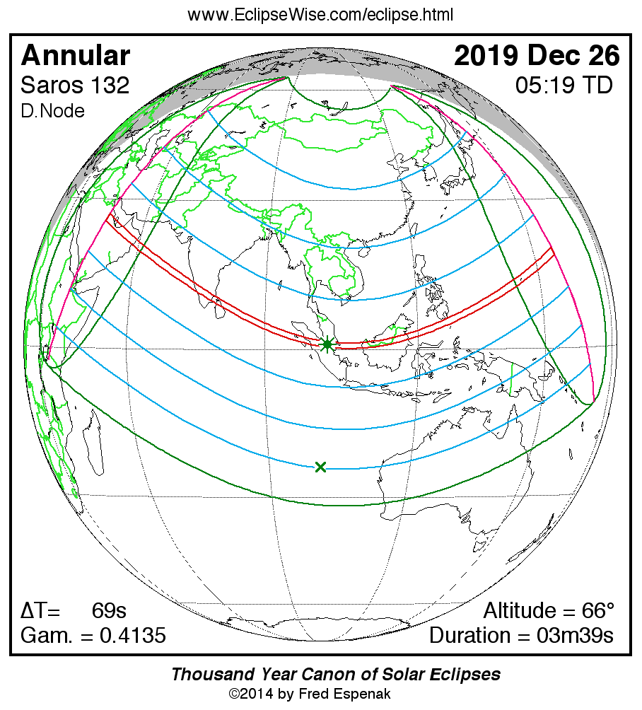
Annular Solar Eclipse of 2019 Dec 26
The last eclipse of the year is the third solar eclipse. It occurs in Sagittarius at the Moon’s descending node. The central track of the annular eclipse crosses the Saudi Arabian Peninsula, southern India, Sumatra, Borneo, Philippines and Guam. A partial eclipse is visible from a much larger region covering much of Asia, northeast Africa, Oceana and western Australia (Figure 6).
The central path begins in Saudi Arabia about 220 kilometers northeast of Riyadh at 03:43 UT1. The path width is 164 kilometers and the duration of annularity is 2 minutes 59 seconds. Although Bahrain lies just outside the path, the southern half of Qatar is within the path of annularity. Continuing to the southeast, the path crosses the southern United Arab Emirates and northern Oman before entering the Arabian Sea.
The antumbral shadow reaches the southwest coast of the Indian subcontinent at 03:56 UT1. On the central line near Kannar, the duration of annularity is 3 minutes 12 seconds, the Sun’s altitude is 32°, and the path width is 129 kilometers.
Traveling with a ground speed of about 1.1 kilometers/second, it takes the antumbral shadow 8 minutes to cross India reaching its southeast coast at 04:04 UT1. It sweeps over northern Sri Lanka before heading into the Bay of Bengal.
Malaysia’s Palau and Sumatra are the next landfall as well as the city-nation of Singapore. Greatest eclipse occurs in eastern Sumatra at 05:17:48 UT1, with an annular duration of 3 minutes 39 seconds. Racing across the South China Sea, the central track crosses Borneo and the Celebes Sea as it curves to the northeast and passes south of the Philippines archipelago.
As it heads across the western Pacific, the antumbral shadow encounters Guam at 6:56 UT1. The Sun’s altitude is 13° during the 3 minute 10 second annular phase. Three minutes later, the umbra reaches Earth’s terminator and rises back into space.
During the course of its 3.3-hour trajectory, the antumbra's track is approximately 12,900 kilometers long and covers 0.34% of Earth's surface area. Path coordinates and central line circumstances are presented in Table 6.
Local circumstances and eclipse times for a number of cities in Asia are listed in Table 7. All times are given in Local Time. The Sun's altitude and azimuth, eclipse magnitude and eclipse obscuration are all given at the instant of maximum eclipse. The 2019 December 26 Solar Eclipse Circumstances Calculator is an interactive web page that can quickly calculate the local circumstances for the eclipse from any geographic location not included in Table 7
This is the 46th eclipse of Saros 132 (Espenak and Meeus, 2006). The series began on 1208 Aug 13 with a string of 20 partial eclipses. The series continued with 33 consecutive annular eclipses from 1569 Mar 17 to 2146 Mar 12. Saros 132 then changes character with 2 hybrid eclipses from 2164 Mar 23 to 2182 Apr 03. The first of 7 total eclipses occurs on 2200 Apr 14. The series reverts back to partial with the eclipse of 2326 Jun 30. It will continue producing partial eclipses until the series ends on 2470 Sep 25. In all, Saros 132 produces 71 solar eclipses in the sequence of 20 partial, 33 annular, 2 hybrid, 7 total and 9 partial eclipses. Complete details for the series can be found at: Saros 132.
For additional details on this event, see the EclipseWise Prime Page on the Annular Solar Eclipse of 2019 December 26.
Explanatory Information
Solar Eclipse Figures
Lunar Eclipse Figures
Shadow Diameters and Lunar Eclipses
Danjon Scale of Lunar Eclipse Brightness
Crater Timings During Lunar Eclipses
Eclipse Altitudes and Azimuths
The altitude a and azimuth A of the Sun or Moon during an eclipse depend on the time and the observer's geographic coordinates. They are calculated as follows:
         h = 15 (GST + UT - α ) + λ
         a = arcsin [sin δ sin φ + cos δ cos h cos φ]
         A = arctan [-(cos δ sin h)/(sin δ cos φ - cos δ cos h sin φ)]

where

         h = hour angle of Sun or Moon
         a = altitude
         A = azimuth
         GST = Greenwich Sidereal Time at 0:00 UT
         UT = Universal Time
         α = right ascension of Sun or Moon
         δ = declination of Sun or Moon
         λ = observer's longitude (east +, west -)
         φ = observer's latitude (north +, south -)
During the eclipses of 2019, the values for GST and the geocentric Right Ascension and Declination of the Sun or the Moon (at greatest eclipse) are as follows:
         Eclipse               Date           GST         α          δ

         Partial Solar       2019 Jan 06     7.024     19.116    -22.543
         Total Lunar         2019 Jan 21     8.019      8.208     20.337
         Total Solar         2019 Jul 02    18.703      6.771     23.010
         Partial Lunar       2019 Jul 16    19.629     19.733    -21.881
         Annular Solar       2019 Dec 26     6.295     18.299    -23.372
Two web based tools that can also be used to calculate the local circumstances for all solar and lunar eclipses visible from any location. They are the Javascript Solar Eclipse Explorer and the Javascript Lunar Eclipse Explorer. The URLs for these tools are:
Javascript Solar Eclipse Explorer: www.EclipseWise.com/solar/JSEX/JSEX-index.html
Javascript Lunar Eclipse Explorer: www.EclipseWise.com/lunar/JLEX/JLEX-index.html
Eclipses During 2020
In 2020, there are two solar eclipses and four penumbral lunar eclipses:
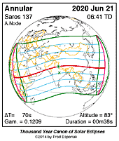
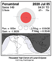
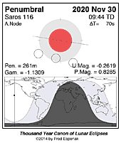
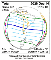
A full report Eclipses During 2020 will be published in Observer's Handbook:2020
Eclipse Web Sites
EclipseWise.com is a website dedicated to predictions and information on eclipses of the Sun and Moon. It offers a graphically intuitive interface and contains maps, diagrams, tables, and information about every solar and lunar eclipse from 2000 BCE to 3000 CE. This period includes 11898 solar eclipses and 12064 lunar eclipses.
Much of EclipseWise.com is based on the Thousand Year Canon of Solar Eclipses 1501 to 2500 (Espenak 2014a) and the Thousand Year Canon of Lunar Eclipses 1501 to 2500 (Espenak 2014b). These eclipse predictions use the Jet Propulsion Lab's DE406 — a computer ephemeris used for calculating high precision coordinates of the Sun and Moon for thousands of years into the past and future.
The World Atlas of Solar Eclipses provides maps of all central eclipse paths from 2000 BCE to 3000 CE.
Information on solar and lunar eclipse photography, and tips on eclipse observing and eye safety may be found at:
For web versions of this article for other years, visit the following:Eclipse Publications
|

|

|

|
|
|
Acknowledgments
All eclipse predictions were generated on a Macintosh G4 PowerPC using algorithms developed from the Explanatory Supplement [1974] with additional algorithms from Meeus, Grosjean, and Vanderleen [1966]. The solar and lunar coordinates used in the eclipse predictions are based on the JPL DE405. For lunar eclipses, the diameter of the umbral and penumbral shadows were calculated using Danjon's rule of enlarging Earth's radius by 1/85 to compensate for the opacity of the terrestrial atmosphere; corrections for the mean effects of oblateness have also been included.
All calculations, diagrams, tables, and opinions presented in this paper are those of the author, and he assumes full responsibility for their accuracy.
Permission is granted to reproduce the eclipse data when accompanied by a link to this page and an acknowledgment:
"Eclipse Predictions by Fred Espenak, EclipseWise.com"
The use of diagrams and maps is permitted provided that they are unaltered (except for re-sizing) and the embedded credit line is not removed or concealed.
Footnotes
[1] The instant of greatest eclipse for lunar eclipses occurs when the distance between the Moon's shadow axis and Earth's geocenter reaches a minimum.
[2] UT1 or Universal Time is the mean solar time on the Prime Meridian at Greenwich, England. Civil time signals are transmitted according to Coordinated Universal Time (UTC), which is based on International Atomic Time (TAI) with leap seconds added at irregular intervals to compensate for the slowing of Earth's rotation. The leap seconds keep UTC within 0.9 second of UT1.
[3] Penumbral eclipse magnitude is defined as the fraction of the Moon's diameter occulted by Earth's penumbral shadow.
[4] The Saros is a period of 6,585.3 days (18 years 11 days 8 hours) in which eclipses (both solar and lunar) repeat. The geometry isn't exact but close enough for a Saros series to last 12 or more centuries.
[5] The instant of greatest eclipse for solar eclipses occurs when the distance between the Moon's shadow axis and Earth's geocenter reaches a minimum.
[6] Eclipse magnitude for solar eclipses is defined as the fraction of the Sun's diameter occulted by the Moon.
[7] Eclipse obscuration is defined as the fraction of the Sun's area occulted by the Moon.
[8] Umbral eclipse magnitude is defined as the fraction of the Moon's diameter occulted by Earth's umbral shadow.
[9] Gamma is the distance of the Moon's shadow axis from Earth's center (in Earth radii) when it reaches its minimum absolute value.
References
Chauvenet, W., Manual of Spherical and Practical Astronomy, Vol.1, 1891 (Dover edition 1961).
Danjon, A., "Les éclipses de Lune par la pénombre en 1951," L'Astronomie, 65, 51-53 (Feb. 1951).
Espenak, F., and Meeus, J., Five Millennium Canon of Solar Eclipses: –1999 to +3000 (2000 BCE to 3000 CE), NASA TP–2006-214141, Goddard Space Flight Center, Greenbelt, MD, 2006.
Espenak, F., and Meeus, J., Five Millennium Canon of Lunar Eclipses: –1999 to +3000 (2000 BCE to 3000 CE), NASA TP–2009-214172, Goddard Space Flight Center, Greenbelt, MD, 2009a.
Espenak, F., and Meeus, J., Five Millennium Catalog of Lunar Eclipses: –1999 to +3000 (2000 BCE to 3000 CE), NASA TP–2009-214173, Goddard Space Flight Center, Greenbelt, MD, 2009b.
Espenak, F., and Meeus, J., Five Millennium Catalog of Solar Eclipses: –1999 to +3000 (2000 BCE to 3000 CE), NASA TP–2009-214174, Goddard Space Flight Center, Greenbelt, MD, 2009c.
Espenak, F., Thousand Year Canon of Solar Eclipses 1501 to 2500, AstroPixels Publishing, Portal, AZ, 2014.
Espenak, F., Thousand Year Canon of Lunar Eclipses 1501 to 2500, AstroPixels Publishing, Portal, AZ, 2014.
Espenak, F., 21st Century Canon of Solar Eclipses, AstroPixels Publishing, Portal, AZ, 2016.
Espenak, F., Atlas of Central Solar Eclipses in the USA, AstroPixels Publishing, Portal, AZ, 2016.
Explanatory Supplement to the Astronomical Ephemeris and the American Ephemeris and Nautical Almanac, Her Majesty's Nautical Almanac Office, London, 1974.
Eclipse Publications
|
|
|

|