
Total Eclipse of the Sun: August 21, 2017
by Fred Espenak
2017 Total Solar Eclipse Photo Gallery

2017 Total Solar Eclipse Photo Gallery
| States in the Path of Totality | |||
Georgia |
Idaho |
Illinois |
Iowa |
Kansas |
Kentucky |
Missouri |
Montana |
Nebraska |
North Carolina |
Oregon |
South Carolina |
Tennessee |
Wyoming |
||
Introduction
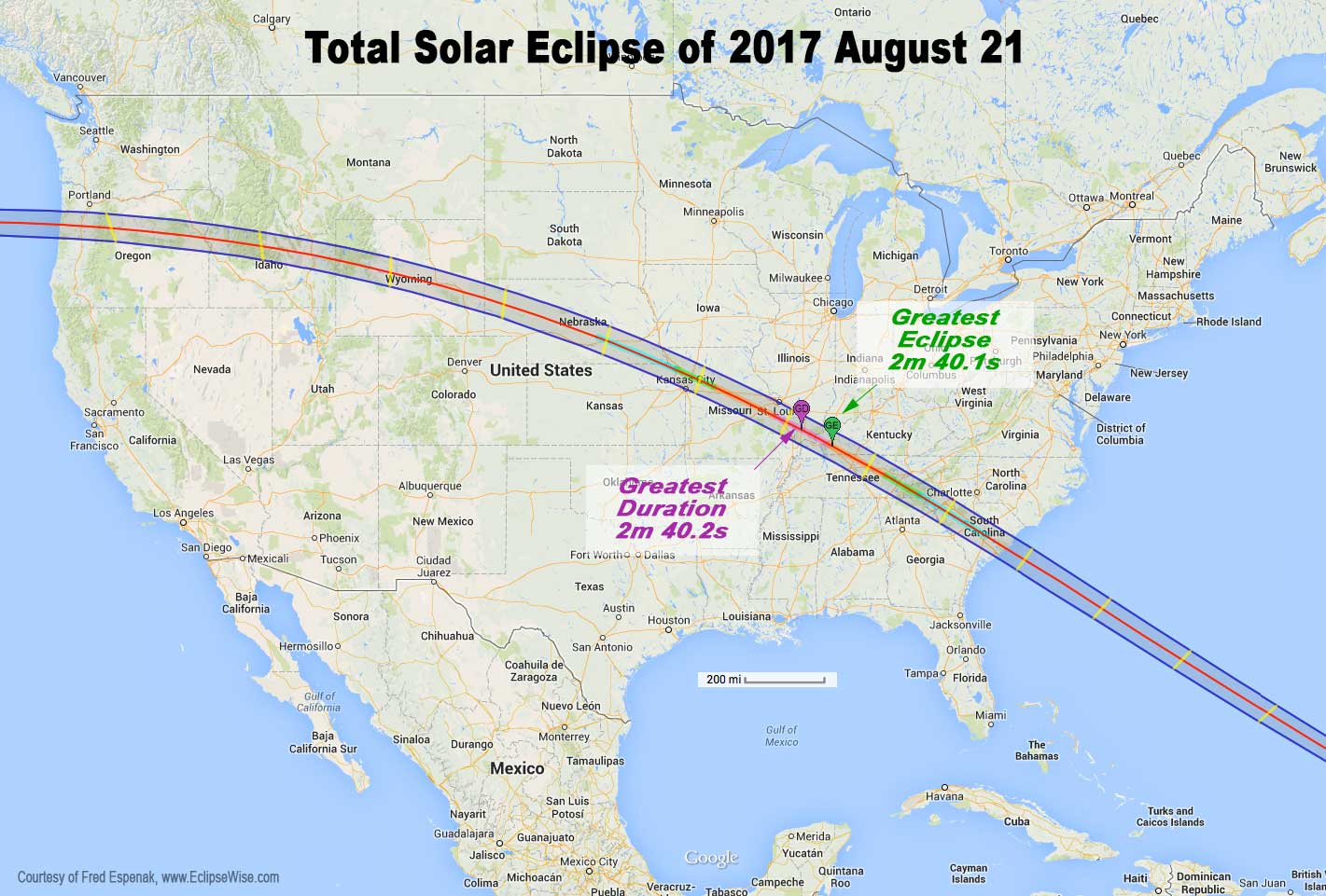
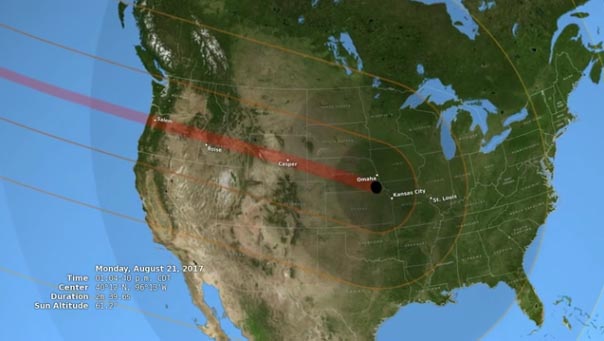
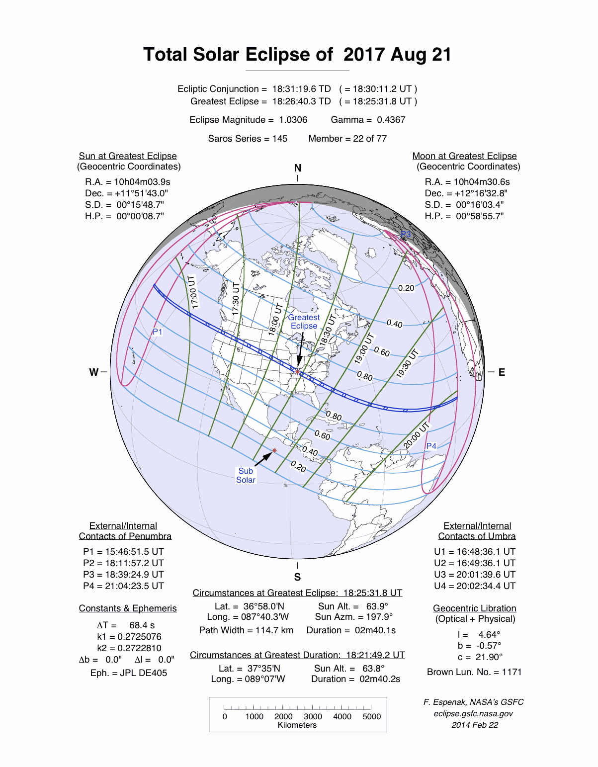
On 2017 August 21, a total eclipse of the Sun is visible from within a narrow corridor that traverses the United States of America. The path of the Moon's umbral shadow begins in northern Pacific and crosses the USA from west to east through parts of the following states: Oregon, Idaho, Wyoming, Nebraska, Kansas, Missouri, Illinois, Kentucky, Tennessee, North Carolina, Georgia, and South Carolina (a tiny corner of Montana [6.09 square miles] and Iowa [0.71 square miles] are also in the path). The Moon's penumbral shadow produces a partial eclipse visible from a much larger region covering most of North America.

Path of the 2017 Total Solar Eclipse
(click to enlarge)
This special web page contains information about the 2017 total eclipse of the Sun. It will be updated with additional details as eclipse day approaches.
The EclipseWise Prime Page for the 2017 August 21 eclipse presents detailed information on this event including the primary eclipse characteristics, conjunction times, geocentric coordinates of the Sun and Moon, lunar libration values, penumbral and umbral shadow contact data, central line data, polynomial Besselian elements and additional links.
Path of Totality
The total solar eclipse of August 21 is the first total eclipse visible from America’s lower 48 states in over 38 years. The last one happened in 1979 and passed through the Pacific Northwest and central Canada in late winter. (see: Total Solar Eclipses in the USA)
The total eclipse is visible from within a narrow corridor that traverses the United States from the Pacific Northwest to the Southeast crossing fourteen states: Oregon, Idaho, Wyoming, Nebraska, Kansas, Missouri, Illinois, Kentucky, Tennessee, Georgia, North Carolina and South Carolina (a tiny corner of Montana and Iowa are also inside the path). A partial eclipse is seen within the much broader path of the Moon's penumbral shadow, which includes all of North America, the northern third of South America, and westernmost Europe and Africa (Orthographic Map)).
The central path begins in the North Pacific about 2400 kilometres west of North America at 16:49 UT1. The Moon’s umbral shadow travels 28 minutes before making first landfall along the Pacific coastline of Oregon at 17:16 UT1 (10:16 am PDT). The Sun's altitude is 39° during a totality lasting 1 minute 59 seconds. Unfortunately the Oregon coast is often subject to heavy morning fog, making it a concern to eclipse watchers.
Rushing east, the umbra crosses the 3,000-foot-high Coast Range and into the Willamette Valley. The cities of Corvallis, Albany and Salem all lie deep in the path and have durations ranging from 1 minute 40 seconds to 1 minute 55 seconds. Coastal fog rarely comes this far inland and the mean cloud amount from ground records is ~50%.
The 10,000-foot-high Cascade Range tends to have a drying effect on the air as the shadow descends into the Columbia Basin. This region is notable for having the statistically lowest cloud amount (25%) along the entire eclipse track. Madras residents get just over 2 minutes of totality. The area will be a major draw for the eclipse and most hotels are already booked.
The elevation through eastern Oregon gradually climbs as the path reaches the Idaho border and the Snake River Plain. While Boise, Idaho's capital, lies just outside the eclipse track, it’s only a short drive to get into the path of totality early on eclipse day. To the east, Idaho Falls is deep in the path where totality lasts 1 minute 49 seconds. The duration is 2 minutes 18 seconds from the central line 34 kilometres further north. The weather prospects here are nearly as good as central Oregon.
Path of the 2017 Total Eclipse through the USA
(click to enlarge)
As it crosses the Teton Range, the shadow enters Wyoming and Grand Teton National Park. With its spectacular mountain scenery, the Tetons are always a popular tourist destination. Add a total eclipse and the region will likely experience some serious congestion. The central line passes through Jackson Hole's airport bringing 2 minutes 20 seconds of totality. Teton Park lies on the dry lee side of the mountains so the weather prospects are promising. But the lack of running room and the ability to reach a better location should weather conditions deteriorate on eclipse day could be an issue.
East of the Wind River Range, the eclipse track stretches out across the high desert terrain of Wyoming. The central line passes though Casper where the duration reaches 2 minutes 26 seconds. Offering a mean cloud amount of ~40%, Casper lies at the intersection of good highways running over a 150 kilometres east and west within the eclipse path. The Astronomical League's annual convention AstroCon 2017 will occur in Casper the week prior to the eclipse.
Gently rolling grasslands dominate much of the Nebraska landscape. Just north of the central line, Alliance enjoys 2 minutes 30 seconds of totality centered on 17:50 UT1 (11:50 am MDT). About 160 kilometres to the southeast, Interstate Highway 80 (I-80) crosses into the eclipse track and follows it for ~390 kilometres. An excellent eclipse viewing strategy is to choose this section of the path since it offers some of the best maneuverability to fine-tune one's location based on the weather forecast in the days leading up to the eclipse.
While North Platte is inside the path, it is just 14 kilometres from the southern limit. Nevertheless, the duration there is 1 minute 46 seconds. The central line is 40 kilometres northeast where totality lasts 2 minutes 33 seconds. Continuing east on I-80, the interstate eventually curves deeper into the path and crosses the central line just south of Grand Island. The central duration is now 2 minutes 36 seconds with the Sun at an altitude of 60°.
From west to east Nebraska’s average elevation slowly drops making the state a bit more susceptible to moist air from the Gulf of Mexico. This is reflected in the mean cloud amount that rises from ~45% to ~55% across the state.
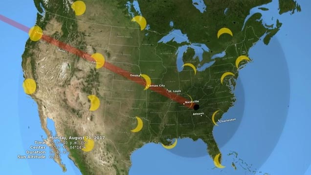
Departing Nebraska the eclipse path crosses the northeastern corner of Kansas and enters Missouri. The southern limit bisects Kansas City so residents there will observe either a deep partial eclipse, a grazing eclipse or a very short total eclipse, depending on their exact location with respect to the path edge. A similar situation holds true in St. Louis, which is bisected by the northern path limit. Missouri cities deep in the path include St. Joseph, Columbia and Jefferson City, all with totalities lasting about 2 and 1/2 minutes.
Crossing the Mississippi River, the track enters southern Illinois. About 10 kilometres south of Carbondale, IL the central line duration reaches its maximum value of 2 minutes 40.3 seconds at 18:21:49 UT1 (1:21:49 pm CDT). Carbondale is being billed as Southern Illinois' "Eclipse Crossroads of America" since it also lies in the path of the Total Solar Eclipse of 2024 Apr 08.
The weather prospects from Missouri to Illinois are strongly influenced by moisture-laden air from the Gulf of Mexico. The average cloud cover from surface observations hovers around 55%. Heavier cloud cover often comes from convective clouds usually developing in the afternoon. Fortunately the cooling effect of the partial phases before totality may help mitigate afternoon cloud formation.
After fording the Ohio River, the umbral shadow enters Kentucky and the flat landscape gradually transforms into small, rolling hills. The instant of greatest eclipse occurs at 18:25:32 UT1 (1:25:32 pm CDT). This is the point where the axis of the lunar shadow passes closest to the centre of Earth. The auspicious event takes place in an unassuming sorghum field about 20 kilometres northwest of Hopkinsville, KY. The duration at greatest eclipse, 2 minutes 40.1 seconds, is less than 0.2 seconds shorter than greatest duration near Carbondale. While many may make a big fuss over a few tenths of a second, a clear sky is far more important. The weather forecast the day before the eclipse should be the ultimate guide in choosing a viewing site and not duration.
The eclipse track heads to the southeast as it enters Tennessee. Nashville is the largest city in the state lying within the path of totality. It is located ~2/3's of the way from the central line to the southern limit and receives 1 minute 56 seconds of totality. Another 44 seconds can be added by traveling 40 kilometres north to the central line. The eastern Tennessee cities of Knoxville and Chattanooga both lie just outside the path where ultra deep partial eclipses will be seen.
At Tennessee's eastern border with North Carolina, the eclipse track crosses the Blue Ridge Mountains. While offering an inviting landscape of green mountains and valleys, this area has the highest mean cloud cover (~80%) along the entire track. To the south, the path clips the northeastern corner of Georgia before entering, South Carolina.
Greenville and Andersonville are both deep in the path with the central line passing between them. The duration from the cities is 2 minutes 11 seconds and 2 minutes 34 seconds, respectively, centered at 19:39 UT1 (2:39 pm EDT) and the Sun at 63° altitude. Columbia is to the southeast and has a duration of 2 minutes 30 seconds. Just inside the southern limit is historic Charleston. The duration from downtown is 1 minute 29 seconds, while a 50-kilometre drive northeast to the central line offers 2 minutes 34 seconds.
While the elevation drops sharply across South Carolina as the eclipse track heads to the Atlantic coast, afternoon cloud formation is often triggered by moist air from the Atlantic. The mean cloud amount ranges from 60% to 70%. The most promising observing sites are right along the Atlantic coast, but only if a sea breeze is present on eclipse day to keep clouds formed further inland at bay. Leaving the American coastline, the lunar shadow begins a 75-minute-long journey covering 5800 kilometres across the Atlantic before leaving Earth's surface at 20:02 UT1. Over the course of its 3.2-hour trajectory, the umbra's track is approximately 13,900 kilometres long and covers 0.26% of Earth's surface area.
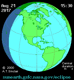
Orthographic Map of the Total Solar Eclipse
The following map shows the overall regions of visibility of the partial eclipse as well as the path of the Total eclipse through the USA. It uses coastline data from the World Data Base II (WDB).
Interactive GoogleMap of the Path of Totality
An implementation of Google Map has been created which includes the central path of the 2017 total solar eclipse. This allows the user to select any portion of the path and to zoom in using either map data or Earth satellite data.
Other interactive eclipse maps include those by Xavier Jubier and Bill Kramer.

Path of the 2017 Total Eclipse through the USA
(click to enlarge)
Intermediate Detail Maps of the Path of Totality
The following maps show the path of the 2017 total solar eclipse in intermediate detail for locations across the United States. The path of totality is shaded for clarity, and lines of maximum eclipse have been plotted (in yellow) at 10-minute intervals. The Coordinated Universal Time (UTC), the duration of totality (minutes:seconds) and the Sun's altitude (degrees) is given on the eclipse central line at 10-minute intervals. The maps also include cities, major towns, highways, rivers, lakes and parks.
| Map Number | Title/Description | Map File |
| Map West | Total Solar Eclipse Path through Western USA | JPG |
| Map East | Total Solar Eclipse Path through Eastern USA | JPG |
| Map 1 | Total Solar Eclipse Path through Oregon | JPG |
| Map 2 | Total Solar Eclipse Path through Idaho | JPG |
| Map 3 | Total Solar Eclipse Path through Wyoming | JPG |
| Map 4 | Total Solar Eclipse Path through Nebraska and Kansas | JPG |
| Map 5 | Total Solar Eclipse Path through Missouri and Illinois | JPG |
| Map 6 | Total Solar Eclipse Path through Kentucky, Tennesse, and North Carolina | JPG |
| Map 7 | Total Solar Eclipse Path through South Carolina and Georgia | JPG |
Maximum Detail Maps of the Path of Totality
The following maps show the path of the 2017 total solar eclipse in maximum detail for the United States and by state. Within the path of totality, curves of constant duration have been plotted for the total phase. Note that the constant duration curves are calculated using the exact shape of the Moon. Mountains and valleys can shorten or lengthen the duration of totality by 1-3 seconds. The maps also include the general terrain highlighting major towns, cities, and highways.
These maximum detail maps were prepared by Michael Zeiler (Esri) using a high level CAD/GIS (Computer Aided Drawing / Graphic Information System) with data provided by Fred Espenak (NASA/GSFC) and Xavier Jubier. These poster-size maps can be saved to your computer for printing. You will have to scale the print size in your printer dialog to fit them to the page size you are printing.
| Map Number | Title/Description | Map File |
| Map 1 | Hemispheric view of the total solar eclipse | JPG |
| Map 2 | Total solar eclipse over the United States | JPG |
| Map 3 | Total solar eclipse over Oregon | JPG |
| Map 4 | Total solar eclipse over Idaho | JPG |
| Map 5 | Total solar eclipse over Wyoming | JPG |
| Map 6 | Total solar eclipse over Nebraska | JPG |
| Map 7 | Total solar eclipse over Missouri and Illinois | JPG |
| Map 8 | Total solar eclipse over Kentucky, Tennesse, and North Carolina | JPG |
| Map 9 | Total solar eclipse over South Carolina and Georgia | JPG |
States the Path of Totality
The path of totality crosses the United States from west to east and passes through parts of a fourteen states: Oregon, Idaho, Wyoming, Nebraska, Kansas, Missouri, Illinois, Kentucky, Tennessee, Georgia, North Carolina, and South Carolina (the path also clips a tiny corner of Montana and Iowa). Within this narrow track the Sun's bright disk is completely hidden for up to 2 3/4 minutes while the Sun's corona is revealed.
Visit the following web pages for each of the states in the path of totality
| States in the Path of Totality | |||
Georgia |
Idaho |
Illinois |
Iowa |
Kansas |
Kentucky |
Missouri |
Montana |
Nebraska |
North Carolina |
Oregon |
South Carolina |
Tennessee |
Wyoming |
||
Eclipse Media
- USA TODAY
- 2017 Eclipse Presentation at NEAF
Fred Espenak speaks about the 2017 eclipse at the 2016 Northeast Astronomy Forum.
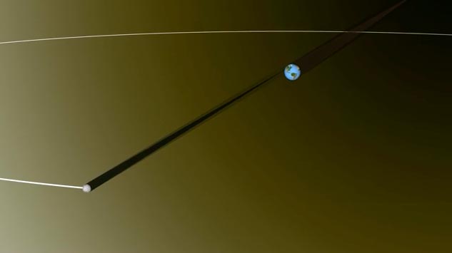
- Animation of Moon's Shadow During 2017 Eclipse
Map courtesy of Michael Zeiler
GreatAmericanEclipse.com
- 2016 Bullitt Lecture (on 2017 Eclipse) at U. of Louisville
2017 Eclipse Animations & Movies


Eclipse Weather
- Weather Prospects and Maps - eclipse meteorologist Jay Anderson
- View 60 Clear Sky Charts established for locations along the path of totality.
(It will only be useful from 19 August and onward for the eclipse weather along the path).
Safe Eclipse Viewing
Every total eclipse of the Sun begins and ends with a partial eclipse. The partial phases require either a projection technique or a special solar filter to be viewed safely. Read more about this at Safe Solar Eclipse Viewing.
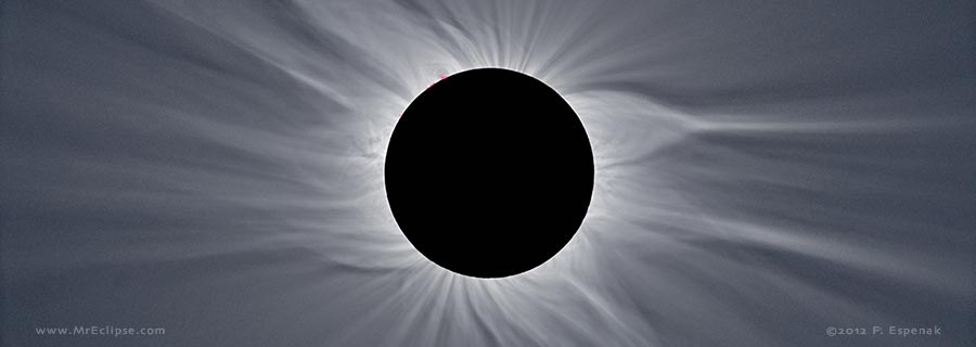
Of course during the few brief minutes of Totality when the Sun's disk is completely covered by the Moon, it is then safe to look directly at the Sun with the naked eye or through a telescope or binoculars.
- Safe Solar Eclipse Viewing - summarizes several safe ways to view an eclipse of the Sun
- Solar Filters and Eclipse Glasses - a list of links
- How to Safely View a Solar Eclipse
- A Guide to Safe Solar Filters
- Sources for Solar Filters
- Telescope Manufacturers
- Telescope & Accessory Retailers

Safe Solar Eclipse Glasses |

Rainbow Symphony Eclipse Shades |

Thousand Oaks Optical Solar Filters |

Great American Eclipse Store |
Eclipse Bulletin: Total Solar Eclipse of 2017 August 21
Eclipse Bulletin: Total Solar Eclipse of 2017 August 21 is the ultimate guide to this highly anticipated event. Written by two of the leading experts on eclipses, Fred Espenak and Jay Anderson, the bulletin is a treasure trove of facts on every conceivable aspect of the eclipse. The exact details about the path of the Moon's shadow can be found in a series of tables containing geographic coordinates, times, altitudes, and physical dimensions. A set of high resolution maps plot the total eclipse path across the USA. They show hundreds of cities and towns in the path, the location of major roads and highways, and the duration of totality with distance from the central line.
Local circumstances tables for more than 1000 cities across the USA provide times of each phase of the eclipse along with the eclipse magnitude, duration and Sun's altitude. Additional tables cover the eclipse circumstances for cities in Canada, Mexico, Central and South America and Europe. An exhaustive climatological study identifies areas along the eclipse path where the highest probability of favorable weather may be found. A travelogue highlights key locations in the eclipse track from Oregon through South Carolina. Finally, comprehensive information is presented about solar filters and how to safely observe and photograph the eclipse.
The Portal To The Universe Blog discusses the 2017 Eclipse Bulletin in more detail.
|
Eclipse Bulletin: Total Solar Eclipse of 2017 August 21 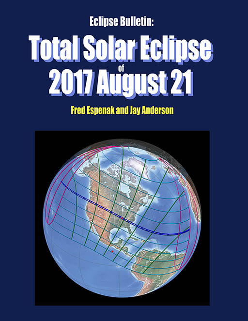
Click for more information |
Highlights of Eclipse Bulletin: Total Solar Eclipse of 2017 August 21
Click for more information |
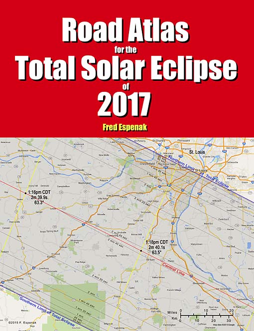
Road Atlas for the Total Solar Eclipse of 2017
The Road Atlas for the Total Solar Eclipse of 2017 contains a comprehensive series of 37 high resolution maps of the path of totality across the USA.
The large scale (1:74,000 or 1 inch = 11 miles) shows both major and minor roads, towns and cities, rivers, lakes, parks, national forests, wilderness areas and mountain ranges.
Armed with this atlas and the latest weather forecasts, the road warrior is ready to chase totality no matter where it takes him/her along the 2500-mile-long path. This mobile strategy offers the highest probability of witnessing the spectacular 2017 total eclipse in clear skies.
The 48-page book measures 8.5 x 11 inches. Available in Black & White and Color Editions.
For more information visit Road Atlas for the Total Solar Eclipse of 2017.

Total Eclipse or Bust! A Family Road Trip
"TOTAL Eclipse or Bust! A Family Road Trip" is a book for the entire family. The story follows a typical family on a road trip to see the 2017 total eclipse of the Sun. Along the way the children learn all about the how and why of eclipses in a friendly and an uncomplicated way. The book also provides basic information about how to view a total solar eclipse and where to go for America's great eclipse on August 21, 2017.
Finally, comprehensive information is presented about solar filters and how to safely observe and photograph the eclipse.
This full color 38-page book measures 8.5 x 11 inches.
For more information visit Total Eclipse or Bust! A Family Road Trip.
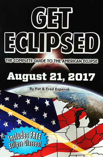
Get Eclipsed: The Complete Guide to the American Eclipse
Get Eclipsed is an easy to read, family friendly, inexpensive 2017 eclipse guide for everyone, especially if the total eclipse of the Sun on August 21, 2017 will be your first one.
Get Eclipsed features:
- How and Why Solar Eclipses Happen
- Science and History of Solar Eclipses
- Fun Facts for the Entire Family
- Helpful Hints for Safe Viewing
- Illuminating Maps and Diagrams
- Eclipse times for over a hundred cities
- Two (2) pairs of Solar Eclipse Glasses
For more information visit Get Eclipsed: The Complete Guide to the American Eclipse.
Additional Links for 2017 August 21 Total Solar Eclipse
- Prime Page: Total Solar Eclipse of 2017 Aug 21 - EclipseWise general information on the eclipse
- Special News Page: Total Solar Eclipse of 2017 Aug 21 - major resources and links for the eclipse
- Orthographic Map: Total Solar Eclipse of 2017 Aug 21 - detailed map of eclipse visibility
- Animated Map: Total Solar Eclipse of 2017 Aug 21 - animated map of the Moon's shadows across Earth
- Google Map: Total Solar Eclipse of 2017 Aug 21 - interactive map of the eclipse path
- Path Table: Total Solar Eclipse of 2017 Aug 21 - coordinates of the central line and path limits
- Circumstances Table: Total Solar Eclipse of 2017 Aug 21 - eclipse times for hundreds of cities
- Saros 145 Table - data for all eclipses in the Saros series
- Total Solar Eclipse of 2017 Aug 21 - Google search for links to this eclipse
- Great American Eclipse 2017 - an exhaustive collection of maps and merchandise for the 2017 eclipse by Michael Zeiler
- Eclipse 2017 - a comprehensive website by Dan McGlaun
- National Eclipse - Dave Clark's website on the 2017 eclipse
- Eclipsophile.com - Weather for the 2017 Eclipse
The Total Solar Eclipse of 2006 Mar 29 as seen from Jalu, LIBYA.
(click to visit photo gallery)
Links to Additional Solar Eclipse Information
- Home - home page of EclipseWise with predictions for both solar and lunar eclipses
- Solar Eclipses - primary page for solar eclipse predictions
- Solar Eclipse Links - detailed directory of links
- 21st Century Catalog of Solar Eclipses - including the years 2001 to 2100
- Total Solar Eclipses in the USA - maps for all total solar eclipses in the USA from 1001 to 3000
- Annular Solar Eclipses in the USA - maps for all annular solar eclipses in the USA from 1001 to 3000
- Hybrid Solar Eclipses in the USA - maps for all hybrid solar eclipses in the USA from 1001 to 3000
- Javascript Solar Eclipse Explorer - find all solar eclipses visible from a city
- Six Millennium Catalog of Solar Eclipses - covers the years -2999 to +3000 (3000 BCE to 3000 CE)
- Catalog of Solar Eclipse Saros Series - covers Saros series -29 through 190
- Javascript Solar Eclipse Explorer - calculate all lunar eclipses visible from a city
- Thousand Year Canon of Solar Eclipses 1501 to 2500 - link to the publication
Solar Eclipse Photography
- Solar Eclipse Photography: How to Photograph a Solar Eclipse (MrEclipse)
- Solar Eclipse Photography: How to Photograph a Solar Eclipse (Nikon)
- Solar Eclipse Photographs: Index to Solar Eclipse Photographs
- Solar Eclipse Reports: Index to Solar Eclipse Reports
Solar Eclipse Viewing
- Solar Eclipses for Beginners - a primer on solar eclipse basics
- Safe Solar Eclipse Viewing - summarizes several safe ways to view an eclipse of the Sun
- Solar Filter and Eclipse Glasses - a list of links
- Observing Solar Eclipses Safely - instructions for safely viewing an eclipse of the Sun