2017 Total Solar Eclipse in Oregon
by Fred Espenak
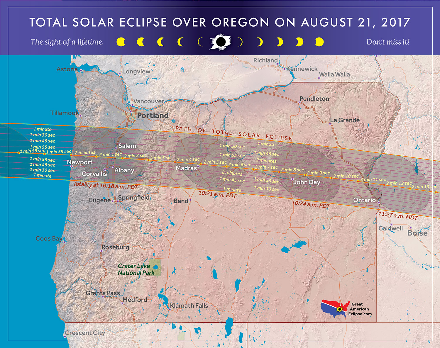
The 2017 Eclipse Path in Oregon
Map courtesy of Michael Zeiler
GreatAmericanEclipse.com
The 2017 Total Solar Eclipse in Oregon
On 2017 August 21, a total eclipse of the Sun is visible from within a narrow corridor that traverses the United States of America. The path of the Moon's umbral shadow begins in northern Pacific and crosses the USA from west to east through parts of the following states: Oregon, Idaho, Wyoming, Nebraska, Kansas, Missouri, Illinois, Kentucky, Tennessee, North Carolina, Georgia, and South Carolina (a tiny corner of Montana and Iowa are also in the path). A partial eclipse visible from a much larger region covering all of North America (See Map).
The path of the Moon's umbral shadow begins in the North Pacific and reaches the western coastline of Oregon at 17:16 UT1 (10:16 am PDT). The Sun's altitude is 39° during a totality lasting 1 minute 59 seconds. Unfortunately the Oregon coast is often subject to heavy morning fog, making it a concern to eclipse watchers.
Rushing east, the umbra crosses the 3,000-foot-high Coast Range and into the Willamette Valley. The cities of Corvallis, Albany and Salem all lie deep in the path and have durations ranging from 1 minute 40 seconds to 1 minute 55 seconds. Coastal fog rarely comes this far inland. The mean cloud amount from ground records is ~50% making this area a reasonably good choice for eclipse watchers.
The Moon's umbra then crosses the 10,000-foot-high Cascade Range, which tends to have a drying effect on the air as the shadow descends into the Columbia Basin. This region is notable for having the statistically lowest cloud amount (25%) along the entire eclipse track. Madras residents get just over 2 minutes of totality. The area will be a major draw for the eclipse and most hotels are already booked.
The elevation through eastern Oregon gradually climbs as the path reaches the Idaho border and the Snake River Plain.
Safe Eclipse Viewing
Every total eclipse of the Sun begins and ends with a partial eclipse. The partial phases require either a projection technique or a special solar filter to be viewed safely. Read more about this at Safe Solar Eclipse Viewing.
Of course during the few brief minutes of Totality when the Sun's disk is completely covered by the Moon, it is then safe to look directly at the Sun with the naked eye or through a telescope or binoculars.
Weather Prospects in Oregon
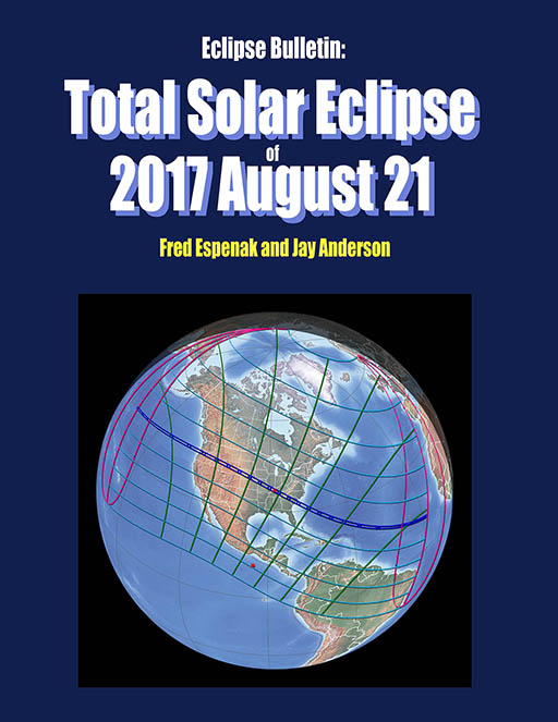
(Excerpts from Eclipse Bulletin: Total Solar Eclipse of 2017 August 21)
Oregon topography is characterized by two north-south mountain chains, the 3,000-foot-high Coast Range and the 10,000-foot-high Cascade Range, and an eastern highland, the Columbia Plateau, which dissolves into a rough jumble of small mountain ranges and river basins toward the Idaho border. Between the Coast and Cascade Ranges, the terrain descends into the Willamette Valley; on the Plateau, the terrain is lowest against the Cascade Range and rises slowly toward the Idaho border, where it encounters the Ochoco Mountains.
The central line of the Moon’s umbral shadow first touches the west coast of the United States just before 10:16 PDT on the south side of the community of Lincoln Beach, Oregon. More precisely, it comes ashore 100 yards south of a small public park called Fishing Rock, a scenic, rocky point accessed by a rough trail that begins on a suburban street amid a cluster of single-family homes and continues through a dense wood before opening toward the ocean. It’s a fitting place to start the eclipse, since the area was also in the path of the last total eclipse through mainland USA in 1979.
Even in summer, the Oregon coast is a cloudy region, lying within the main track of Pacific weather systems moving onto the continent and subject to the cloud-making influence of the Coast Range, which lies barely a mile or two inland. Observations from weather stations (mostly airports) record an average cloud amount of 64% at Newport and a range from 52% to 78% at other locations along the coast. Cloud statistics based on satellite observations confirm the high cloud average along the Pacific coast. The satellite data reveals that afternoon cloudiness along the coast is much lower than in the morning, but the eclipse comes at mid-morning when the cloud-clearing influence of the Sun is just beginning to be felt. Cooling associated with the oncoming lunar shadow may bring an increase in cloudiness though it will depend on the character of the day’s weather.
The cool offshore waters along the northwest Pacific coast are good fog makers, and though the fog tends to remain offshore, tendrils of mist are commonly found drifting across the beaches. The misty air is drawn inland by the land warming during the day and, though it tends to be relatively transparent, the moist and salty air is not kind to cameras and telescopes. Of course, an offshore wind will dissipate the fog and warm the air, so attention to the eclipse-day forecast will tell whether an inland location might be better.
Inland from Lincoln Beach, the coastal plain quickly transforms to the rough, forested terrain of the Coast Range. Eclipse-viewing options are limited on the coast mountains, in part because the westerly flows from the Pacific bring a lot of cloud when forced to rise over the terrain and partly because visibility is limited on the heavily treed and twisty highway. However, once over the Coast Range and into the Willamette Valley, the eclipse adventurer’s chances improve, though only by a modest amount. The Coast Range is not very high and its ability to dry the air limited. Nevertheless, cloud measurements at Corvallis, Salem, and Aurora show a 15% to 20% reduction in average cloud cover compared to that at Newport. Here again, the afternoon Sun is very efficient at breaking up the morning cloud cover, but the late-morning hour of the eclipse suggests that this may be limited.
A far better eclipse-watching location - perhaps the best anywhere in the USA - is on the east side of the Cascade Mountains, which, at 10,000 feet, are high enough to make a major dent in the cloud-cover statistics. After crossing this range, the eclipse track drops sharply into “The Basin,” a low valley centered on Madras, OR; this valley is the southernmost extent of the Columbia Basin. While there are no cloud observations at Madras, airport observations at Redmond, at the south limit of the umbral shadow, show an average cloud cover of 24% at eclipse time. Over 50% of the reports at Redmond show “clear” skies and 75% have scattered cloud or less. Satellite observations indicate that Madras has the distinction of having the least August cloudiness anywhere along the eclipse track, and just as promising, has almost no difference between morning and afternoon cloud amounts.
Of course, if large-scale frontal systems are moving across the mountains on eclipse day, the impact of terrain will be much less dramatic, even though descending winds at some leeside locations will be able to erode holes in an otherwise extensive cloud cover.
Once past Madras, the lunar shadow moves onto the Ochoco Mountains, where the terrain becomes rougher and the average elevation begins to climb, eventually crossing the peaks of the Columbia Plateau. The Ochoco Mountains and the Plateau are not particularly high ranges, but lofty enough that the average cloud amount increases by ~10%, in step with the terrain. Most of the cloud in eastern Oregon will be convective — showers and thundershowers — and so are susceptible to dissipating as cooler temperatures arrive with the eclipse, provided the buildups are not too large. Nevertheless, if the day is even half promising, these mountains are a good area for eclipse chasing, as Highway 26 follows the track of the umbral shadow all the way to Idaho.
Close to the Idaho border, the eclipse track descends from the Columbia Plateau onto the northwest corner of the Snake River Plain, reaching Interstate 84 and the Idaho border at Ontario, OR. As the track descends to lower elevations, the average cloud cover also retreats to lower values, reaching a mean of ~30% at the Idaho border. Airport observations at Ontario show an average cloudiness of only 16% (with ~75% clear skies!), but the site has only provided a small number of observations over the past years and the values must be viewed with caution. The surface statistics cannot be discounted, however, as satellite observations are also kind to the region, showing average cloud amounts that rival the low values around Madras.
A great source of weather forecasts in the days leading up to the eclipse is Jay Anderson's Eclipsophile.com.
Excerpts from Eclipse Bulletin: Total Solar Eclipse of 2017 August 21. This material may not be reproduced without permission.
Fun Facts for the 2017 Total Eclipse in Oregon
- Across Oregon (from west to east) the width of the path of totality grows from 61.6 to 64.1 miles.
(average width is 62.9 miles) - Across Oregon (from west to east) the central line duration of totality increases from 1 minute 59 seconds to 2 minutes 10 seconds.
- Across Oregon (from west to east) the speed of the Moon's shadow decreases from 2414 to 2078 mph.
(average speed is 2246 mph) - The center of the Moon's shadow sweeps across entire state of Oregon (from west to east) in just 9 minutes 3 seconds (a distance of 336 miles).
- Before 2017, the last two total solar eclipses visible from Oregon were on 1979 Feb 26 and 1918 Jun 08.
- After 2017, the next two total solar eclipses visible from Oregon will be on 2169 Jun 25 and 2207 Nov 20.
Eclipse Viewing Events and Local Pages in Oregon
- OMSI Solar Eclipse Viewing Party - Salem, Oregon
- Oregon Solarfest - Madras, Oregon
- Sublimity Festival Grounds - Sublimity, Oregon
- List of Eclipse Viewing Events - American Astronomical Society (AAS)
- List of Eclipse Viewing Events - NationalEclipse.com
- Eclipse Communities in Oregon - Eclipse2017.org
- If you know of other public eclipse viewing events in Oregon, send them to EclipseWise.
- Camp sites at Oregon State Parks can be reserved no more than nine months in advance
(Nov. 17, 2016 is nine months before the eclipse) - Campgrounds run by U.S. Forest Service can be reserved no more than six months in advance
(Feb. 17, 2017 is six months before the eclipse) - The partial phases require either a projection technique or a special solar filter to be viewed safely. On the other hand it is completely safe to watch Totality with the naked eye. For more information see Safe Solar Eclipse Viewing.
Google Map of 2017 Total Eclipse in Oregon
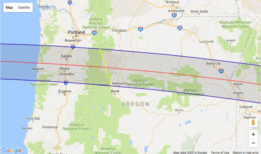
Google Map of 2017 Total Eclipse in Oregon
(Click to use interactive map)
The map above links to an interactive Google map showing the visibility of the Total Solar Eclipse of 2017 Aug 21 in Oregon. The interactive map allows the user to zoom and drag the map as desired. Click the cursor on any location to generate eclipse circumstances from that location.
Eclipse Circumstances for Cities in Oregon
The table below lists eclipse circumstances for a number of cities in Oregon. The following information is given for each city.
- The type of eclipse seen from the city (Partial or Total).
- The times when the partial eclipse begins and ends.
- The times when the total eclipse begins and ends.
- The time of maximum eclipse.
- The altitude on the Sun above the horizon (in degrees) at each of these times.
- The Eclipse Magnitude at maximum eclipse. Eclipse Magnitude is the fraction of the Sun’s diameter occulted by the Moon.
- The Eclipse Obscuration at maximum eclipse. Eclipse obscuration is the fraction of the Sun’s area occulted by the Moon.
- The Duration Total Eclipse is the length of the total phase in minutes and seconds (i.e., totality).
The times appearing in this table include Daylight Saving Time (DST) for all cities in which DST is observed. Report time zone or DST corrections for any city to EclipseWise.
Thanks to Bill Kramer (Eclipse-Chasers.com) for helping to develop the code to generate the above eclipse circumstances table. To calculate predictions for other cities see 2017 Eclipse Circumstances Calculator.
The partial phases require either a projection technique or a special solar filter to be viewed safely. On the other hand it is completely safe to watch Totality with the naked eye. For more information see Safe Solar Eclipse Viewing.
Animation of the Moon's Shadow Across Oregon
The animation above shows the Moon's umbral shadow as it tracks across Oregon. Observers must be inside this path to see the total eclipse. Outside the path only a partial eclipse is seen.
Animation courtesy of Michael Zeiler GreatAmericanEclipse.com.
States in the Path of Totality
The index below gives links to special pages for each of the 12 states in the path of the 2017 total solar eclipse. Note that the eclipse path also crosses a tiny corner of Montana and Iowa, but they are not included in this table.
| States in the Path of Totality | ||
Georgia |
Kentucky |
Oregon |
Idaho |
Missouri |
South Carolina |
Illinois |
Nebraska |
Tennessee |
Kansas |
North Carolina |
Wyoming |
Publications on the 2017 Total Solar Eclipse
11" x 17" poster map of the 2017 eclipse path through Oregon
(GreatAmericanEclipse.com)
Additional Links for the 2017 Total Solar Eclipse
- Prime Page: Total Solar Eclipse of 2017 Aug 21 - EclipseWise general information on the eclipse
- Special News Page: Total Solar Eclipse of 2017 Aug 21 - major resources and links for the eclipse
- Orthographic Map: Total Solar Eclipse of 2017 Aug 21 - detailed map of eclipse visibility
- Animated Map: Total Solar Eclipse of 2017 Aug 21 - animated map of the Moon's shadows across Earth
- Google Map: Total Solar Eclipse of 2017 Aug 21 - interactive map of the eclipse path
- Path Table: Total Solar Eclipse of 2017 Aug 21 - coordinates of the central line and path limits
- Circumstances Table: Total Solar Eclipse of 2017 Aug 21 - eclipse times for hundreds of cities
- Saros 145 Table - data for all eclipses in the Saros series
- Total Solar Eclipse of 2017 Aug 21 - Google search for links to this eclipse
- 2017 Eclipse - American Astronomical Society (AAS)
- 2017 Eclipse in Oregon - GreatAmericanEclipse.com
- Detailed map of the 2017 eclipse path through Oregon - GreatAmericanEclipse.com
- Eclipse Communities in Oregon - Eclipse2017.org
- Eclipsophile.com - Weather for the 2017 Eclipse

Safe Solar Eclipse Glasses |

Rainbow Symphony Eclipse Shades |

Thousand Oaks Optical Solar Filters |

Great American Eclipse Store |
Links to Additional Solar Eclipse Information
- Home - home page of EclipseWise with predictions for both solar and lunar eclipses
- Solar Eclipses - primary page for solar eclipse predictions
- Solar Eclipse Links - detailed directory of links
- 21st Century Catalog of Solar Eclipses - including the years 2001 to 2100
- Total Solar Eclipses in the USA - maps for all total solar eclipses in the USA from 1001 to 3000
- Annular Solar Eclipses in the USA - maps for all annular solar eclipses in the USA from 1001 to 3000
- Hybrid Solar Eclipses in the USA - maps for all hybrid solar eclipses in the USA from 1001 to 3000
- Javascript Solar Eclipse Explorer - find all solar eclipses visible from a city
- MrEclipse.com - Eclipse resources and tips on photography
- Solar Eclipses for Beginners - a primer on solar eclipse basics
- Safe Solar Eclipse Viewing - summarizes several safe ways to view an eclipse of the Sun
- Solar Filter and Eclipse Glasses - a list of links
- Observing Solar Eclipses Safely - instructions for safely viewing an eclipse of the Sun
- How to Photograph a Solar Eclipse - instructions for imaging an eclipse of the Sun
- MrEclipse Photo Index - an index of solar eclipse photographs
Acknowledgments
Some in the JavaScript code used here is based on the work of Deirdre O'Byrne and Stephen McCann. Bill Kramer (Eclipse-Chasers.com) has expanded this code to work with dozens of cities.
The Besselian elements and values of ΔT used in these calculations are from Eclipse Bulletin: Total Solar Eclipse of 2017 August 21.
Permission is freely granted to reproduce this data when accompanied by an acknowledgment:
"Eclipse Predictions by Fred Espenak (EclipseWise.com)"

