
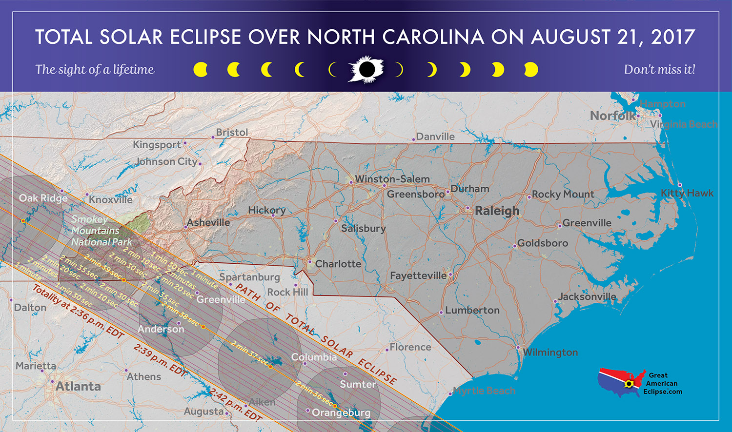
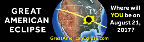
2017 Total Solar Eclipse in North Carolina
by Fred Espenak
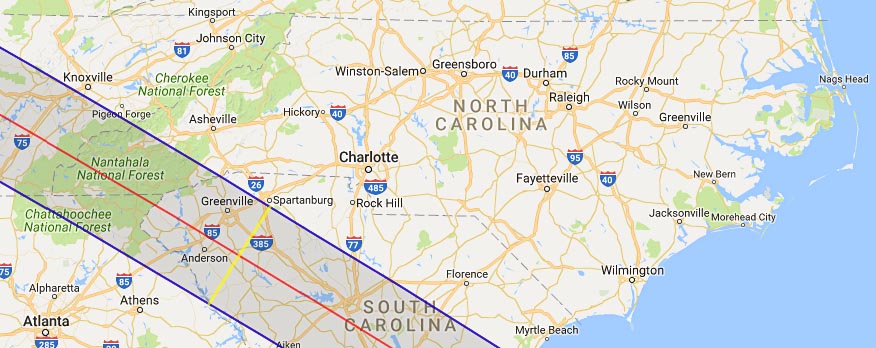
The 2017 Eclipse Path in Georgia
Map courtesy of Michael Zeiler
GreatAmericanEclipse.com
The 2017 Total Solar Eclipse in Georgia and North Carolina
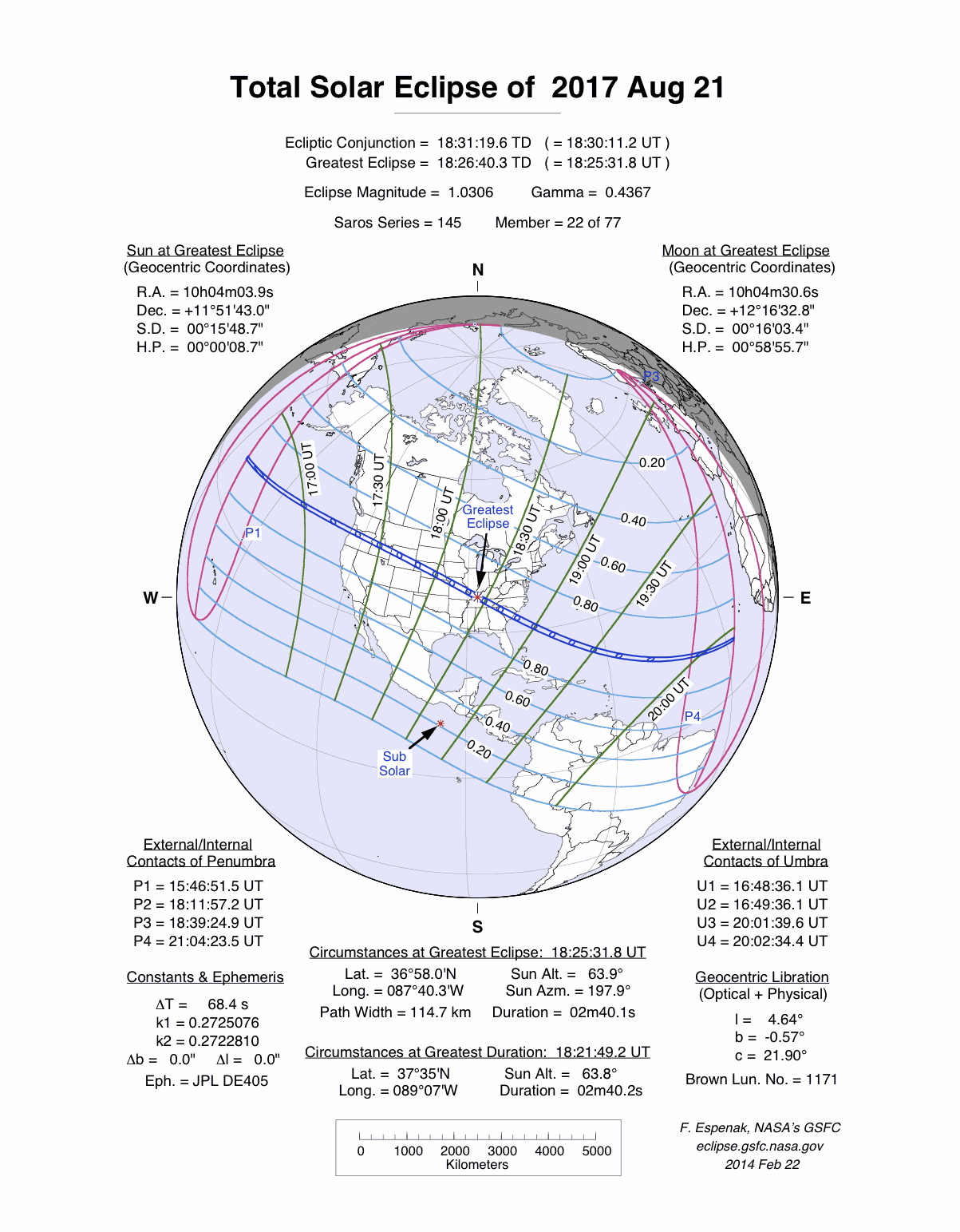
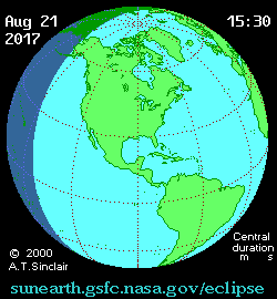
On 2017 August 21, a total eclipse of the Sun is visible from within a narrow corridor that traverses the United States of America. The path of the Moon's umbral shadow begins in northern Pacific and crosses the USA from west to east through parts of the following states: Oregon, Idaho, Wyoming, Nebraska, Kansas, Missouri, Illinois, Kentucky, Tennessee, North Carolina, Georgia, and South Carolina (a tiny corner of Montana and Iowa are also in the path). A partial eclipse visible from a much larger region covering all of North America (See Map).
Knoxville, Chattanooga, and Atlanta are all near misses (eclipse magnitudes 0.997, 0.993 and 0.971) as the eclipse track crosses the Blue Ridge Mountains separating Tennessee from Georgia and North Carolina. However, only the northeast (Chattahoochee National Forest in Georgia) and southwest (Nantahala National Forest in North Carolina) corners of these two states lie within the path. The shadow quickly sweeps across them before entering South Carolina, the final state in the eclipse track.
Safe Eclipse Viewing
Every total eclipse of the Sun begins and ends with a partial eclipse. The partial phases require either a projection technique or a special solar filter to be viewed safely. Read more about this at Safe Solar Eclipse Viewing.
Of course during the few brief minutes of Totality when the Sun's disk is completely covered by the Moon, it is then safe to look directly at the Sun with the naked eye or through a telescope or binoculars.
Weather Prospects in Georgia, North Carolina and South Carolina
(Excerpts from Eclipse Bulletin: Total Solar Eclipse of 2017 August 21)
It is mid-afternoon when the shadow passes though Georgia, North Carolina and South Carolina. Convective cloud buildups will be increasing, replacing the more sedate cloudiness of the morning hours. Even so, the cooling that comes with the eclipse shadow should have a dramatic effect in dissipating the cloudiness provided the buildups haven’t reached the rain-producing stage.
Once over the Blue Ridge Mountains, the track passes over a landscape that is dropping sharply in elevation toward the Atlantic coast. Alas, it has little impact on the cloud cover, as this part of America is now supplied by moisture from the warm waters along the coast and moist air is available in abundance no matter which way the wind blows.
Average cloudiness does not decline on the east side of the Appalachians according to both satellite and surface observations, at least until the Atlantic coast is reached. Eclipse observations will be a challenge. Anderson, SC, has an observed cloudiness of only 50% on average, but the calculation is affected by a strange absence of "scattered" cloud reports and a high frequency in the "few" category in the official record. In all likelihood, the value there will be similar to those elsewhere in the state.
The best observing site in the Carolinas is likely to be right on the coast. Since convective clouds build from the heating of the land, ocean side viewpoints are able to take advantage of lower cloud levels in the cooler air that flows inland from the offshore waters. A site could be selected in Charleston, though the city is well off the central line and the time penalty would be significant. Better is a seaside park such as Buck Hall Recreation Area, about 2 1/2 miles from the central line. Buck Hall is a small park however and cannot accommodate a large crowd. Access to the waterfront is limited by marshy offshore islands and private homes along the coast, but it should be sufficient to be within a mile or two of the Atlantic to take advantage of the cloud-suppressing winds from the east.
South Carolina is no stranger to Atlantic hurricanes and so the possibility of one of these storms in the days surrounding the eclipse, though very small, cannot be discounted. Storm statistics for the Carolina coast reveal that the eclipse comes at a time when the frequency of tropical storms is on the rise toward its mid-September peak. Since 1867, 43 hurricanes have made landfall over South Carolina. Of these, 5 occurred within the four-week period centered on the date of the eclipse. Talk about hurricanes with any long-term South Carolina resident and the names Hugo (1989), Charley (2004), and perhaps Gracie (1959) and Hazel (1954) will come quickly into the conversation. Of these, Hugo, at category 5, was the strongest, bringing wind speeds of 140 mph when it made landfall right over the eclipse track on September 22.
A great source of weather forecasts in the days leading up to the eclipse is Jay Anderson's Eclipsophile.com.
Excerpts from Eclipse Bulletin: Total Solar Eclipse of 2017 August 21. This material may not be reproduced without permission.
Fun Facts for the 2017 Total Eclipse in North Carolina
- The average width of the path of totality is 71.5 miles across North Carolina.
- The central line covers a distance of 42 miles across North Carolina.
- The average central line duration of totality is 2 minutes 38 seconds across North Carolina.
- The average speed of the Moon's shadow is 1452 mph across North Carolina.
- Before 2017, the last two total solar eclipses visible from North Carolina were on 1970 Mar 07 and 1900 May 28.
- After 2017, the next two total solar eclipses visible from North Carolina will be on 2078 May 11 and 2099 Sep 14.
Eclipse Viewing Events and Local Pages in North Carolina
- Eclipse Page - Bryson City, NC
- Eclipse Page - Franlklin, NC
- Eclipse Page - Mountain Valley Center, NC
- Eclipse Page - Jackson County NC
- Eclipse Page - Sapphire Valley Resort, NC
- List of Eclipse Viewing Events - American Astronomical Society (AAS)
- List of Eclipse Viewing Events - NationalEclipse.com
- Eclipse Communities in North Carolina - Eclipse2017.org
- If you know of other public eclipse viewing events in North Carolina, send them to EclipseWise.
- Camp sites at North Carolina State Parks can be reserved no more than nine months in advance
(Nov. 17, 2016 is nine months before the eclipse) - Campgrounds run by U.S. Forest Service can be reserved no more than six months in advance
(Feb. 17, 2017 is six months before the eclipse) - The partial phases require either a projection technique or a special solar filter to be viewed safely. On the other hand it is completely safe to watch Totality with the naked eye. For more information see Safe Solar Eclipse Viewing.
Google Map of 2017 Total Eclipse in North Carolina
Google Map of 2017 Total Eclipse in North Carolina
(Click to use interactive map)
The map above links to an interactive Google map showing the visibility of the Total Solar Eclipse of 2017 Aug 21 in North Carolina. The interactive map allows the user to zoom and drag the map as desired. Click the cursor on any location to generate eclipse circumstances from that location.
Eclipse Circumstances for Cities in North Carolina
The table below lists eclipse circumstances for a number of cities in North Carolina. The following information is given for each city.
- The type of eclipse seen from the city (Partial or Total).
- The times when the partial eclipse begins and ends.
- The times when the total eclipse begins and ends.
- The time of maximum eclipse.
- The altitude on the Sun above the horizon (in degrees) at each of these times.
- The Eclipse Magnitude at maximum eclipse. Eclipse Magnitude is the fraction of the Sun’s diameter occulted by the Moon.
- The Eclipse Obscuration at maximum eclipse. Eclipse obscuration is the fraction of the Sun’s area occulted by the Moon.
- The Duration Total Eclipse is the length of the total phase in minutes and seconds (i.e., totality).
The times appearing in this table include Daylight Saving Time (DST) for all cities in which DST is observed. Report time zone or DST corrections for any city to EclipseWise.
Thanks to Bill Kramer (Eclipse-Chasers.com) for helping to develop the code to generate the above eclipse circumstances table. To calculate predictions for other cities see 2017 Eclipse Circumstances Calculator.
The partial phases require either a projection technique or a special solar filter to be viewed safely. On the other hand it is completely safe to watch Totality with the naked eye. For more information see Safe Solar Eclipse Viewing.
Animation of the Moon's Shadow Across North Carolina
The animation above shows the Moon's umbral shadow as it tracks across North Carolina. Observers must be inside this path to see the total eclipse. Outside the path only a partial eclipse is seen.
Animation courtesy of Michael Zeiler GreatAmericanEclipse.com.
States in the Path of Totality
The index below gives links to special pages for each of the 12 states in the path of the 2017 total solar eclipse. Note that the eclipse path also crosses a tiny corner of Montana and Iowa, but they are not included in this table.
| States in the Path of Totality | ||
Georgia |
Tennessee |
Oregon |
Idaho |
Missouri |
South Carolina |
Illinois |
Nebraska |
Tennessee |
Kansas |
North Carolina |
Wyoming |
Publications on the 2017 Total Solar Eclipse

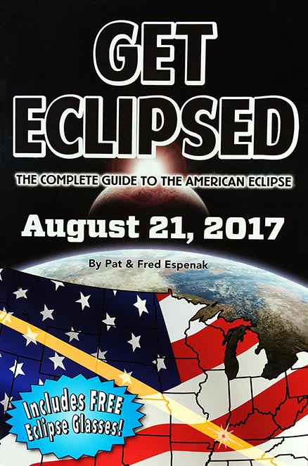
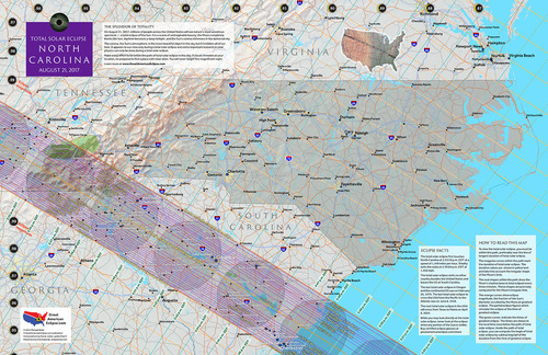
11" x 17" poster map of the 2017 eclipse path through North Carolina
(GreatAmericanEclipse.com)
Additional Links for the 2017 Total Solar Eclipse
- Prime Page: Total Solar Eclipse of 2017 Aug 21 - EclipseWise general information on the eclipse
- Special News Page: Total Solar Eclipse of 2017 Aug 21 - major resources and links for the eclipse
- Orthographic Map: Total Solar Eclipse of 2017 Aug 21 - detailed map of eclipse visibility
- Animated Map: Total Solar Eclipse of 2017 Aug 21 - animated map of the Moon's shadows across Earth
- Google Map: Total Solar Eclipse of 2017 Aug 21 - interactive map of the eclipse path
- Path Table: Total Solar Eclipse of 2017 Aug 21 - coordinates of the central line and path limits
- Circumstances Table: Total Solar Eclipse of 2017 Aug 21 - eclipse times for hundreds of cities
- Saros 145 Table - data for all eclipses in the Saros series
- Total Solar Eclipse of 2017 Aug 21 - Google search for links to this eclipse
- 2017 Eclipse - American Astronomical Society (AAS)
- 2017 Eclipse in North Carolina - GreatAmericanEclipse.com
- Detailed map of the 2017 eclipse path through North Carolina - GreatAmericanEclipse.com
- Eclipse Communities in North Carolina - Eclipse2017.org
- Eclipsophile.com - Weather for the 2017 Eclipse

Safe Solar Eclipse Glasses |

Rainbow Symphony Eclipse Shades |

Thousand Oaks Optical Solar Filters |
Great American Eclipse Store |
Links to Additional Solar Eclipse Information
- Home - home page of EclipseWise with predictions for both solar and lunar eclipses
- Solar Eclipses - primary page for solar eclipse predictions
- Solar Eclipse Links - detailed directory of links
- 21st Century Catalog of Solar Eclipses - including the years 2001 to 2100
- Total Solar Eclipses in the USA - maps for all total solar eclipses in the USA from 1001 to 3000
- Annular Solar Eclipses in the USA - maps for all annular solar eclipses in the USA from 1001 to 3000
- Hybrid Solar Eclipses in the USA - maps for all hybrid solar eclipses in the USA from 1001 to 3000
- Javascript Solar Eclipse Explorer - find all solar eclipses visible from a city
- MrEclipse.com - Eclipse resources and tips on photography
- Solar Eclipses for Beginners - a primer on solar eclipse basics
- Safe Solar Eclipse Viewing - summarizes several safe ways to view an eclipse of the Sun
- Solar Filter and Eclipse Glasses - a list of links
- Observing Solar Eclipses Safely - instructions for safely viewing an eclipse of the Sun
- How to Photograph a Solar Eclipse - instructions for imaging an eclipse of the Sun
- MrEclipse Photo Index - an index of solar eclipse photographs
Acknowledgments
Some in the JavaScript code used here is based on the work of Deirdre O'Byrne and Stephen McCann. Bill Kramer (Eclipse-Chasers.com) has expanded this code to work with dozens of cities.
The Besselian elements and values of ΔT used in these calculations are from Eclipse Bulletin: Total Solar Eclipse of 2017 August 21.
Permission is freely granted to reproduce this data when accompanied by an acknowledgment:
"Eclipse Predictions by Fred Espenak (EclipseWise.com)"