2017 Total Solar Eclipse in Idaho
by Fred Espenak
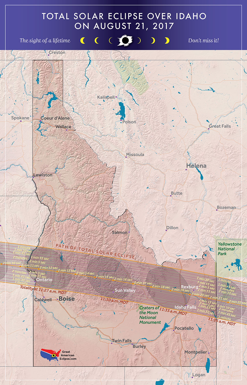
The 2017 Eclipse Path in Idaho
Map courtesy of Michael Zeiler
GreatAmericanEclipse.com
The 2017 Total Solar Eclipse in Idaho
On 2017 August 21, a total eclipse of the Sun is visible from within a narrow corridor that traverses the United States of America. The path of the Moon's umbral shadow begins in northern Pacific and crosses the USA from west to east through parts of the following states: Oregon, Idaho, Wyoming, Nebraska, Kansas, Missouri, Illinois, Kentucky, Tennessee, North Carolina, Georgia, and South Carolina (a tiny corner of Montana and Iowa are also in the path). A partial eclipse visible from a much larger region covering all of North America (See Map).
After crossing the peaks of Oregon's Columbia Plateau, the central eclipse path descends to the northwest corner of the Snake River Plain. The axis of the Moon's shadow crosses the Oregon/Idaho border formed by the Snake River at 17:26 UT1 (10:26 PDT). The duration of totality on the central line is 2 minutes and 10 seconds, the path width is 103 km (64 mi) and the shadow's velocity is 0.93 km/s (2080 mi/hr).
Boise, the state capitol and most populous city (pop. 214,200) in Idaho, stands 24 km (15 mi) outside the path's southern limit and receives a deep partial eclipse of magnitude 0.994. Nevertheless, the city makes a good staging point for the 137 km (85 mi) drive to the central line along Interstate 84.
As the path climbs the Sawtooth Range it encouunters Borah Peak, the highest in Idaho at 12,688 feet. It's 7 miles north of the central line and will experience 2 minutes and 12 seconds of totality. After crossing the Sawtooth Range, the eclipse track descends into the lowlands formed by the Snake River Plain, a several hundred mile wide depression in the Rocky Mountains. Idaho Falls (pop. 58,300) is located inside the path but 33 km (21 mi) south of the central line. The duration of totality is 1 minute and 49 seconds - a 30 second penalty because of its distance from the path's center.
Leaving the Snake River Plain, the umbra enters Wyoming as it climbs over the Teton Range in Teton National Park.
Safe Eclipse Viewing
Every total eclipse of the Sun begins and ends with a partial eclipse. The partial phases require either a projection technique or a special solar filter to be viewed safely. Read more about this at Safe Solar Eclipse Viewing.
Of course during the few brief minutes of Totality when the Sun's disk is completely covered by the Moon, it is then safe to look directly at the Sun with the naked eye or through a telescope or binoculars.
Weather Prospects in Idaho
(Excerpts from Eclipse Bulletin: Total Solar Eclipse of 2017 August 21)
Idaho has one of the rockiest landscapes in the Union, but by good fortune, a significant portion of the track crosses the lowlands of the Snake River Plain, a 100-mile-wide, 375-mile-long depression in the Rocky Mountains that stretches from Ontario, on the Oregon border, in a broad arc that terminates against the Teton Mountains near Idaho Falls. On the west side of Idaho, near Payette and Council, the track barely intercepts the low ground, so that the north limit moves across the narrow Long Valley of the Payette River, while the south limit intercepts westernmost portion of the Snake River Plain. Immediately afterward, the track crosses the rugged and cloudy 10,000-foot peaks of the Sawtooth Range. Before it leaves the state, it drops once more down to the lower elevations of the Snake River, passing over Idaho Falls before reaching the Wyoming border.
The lowest cloud averages in Idaho can be found near the Oregon border, where the track descends from the Ochoco Mountains onto the Snake River Plain. Surface-based observations show a 16% average cloudiness at Ontario, OR (though suspect because of a short observing record), and 27% at Boise. At the eastern end of the plain, where the eclipse track descends from the Sawtooth Range, average cloudiness measured at airport weather stations is ~5% higher - around 30% at both Idaho Falls and Pocatello. Satellite observations of cloud cover mimic the pattern of observations from the ground, but with higher overall values: an average of around 38% near Ontario, climbing to almost 60% over the Sawtooth Range, and then declining to 44% at Idaho Falls.
Satellite observations show that the cloud cover on the Sawtooth Range climbs dramatically during the day, by almost 20%, as the slopes warm and convective clouds build. Clouds also build in the afternoon in the eastern Snake River Plain, near Idaho Falls, but the increase is less than 5% according to space-based observations. Since the lunar shadow passes just before noon, the increase in valley cloud is likely to be small and overcome by eclipse cooling, but the cloud buildups in the mountains may not be so responsive.
The best appraisal for eclipse visibility is the direct measurement of sunshine itself, but the instrumentation to take such recordings are only found at a few stations across the USA. In Idaho, there are two such stations along the eclipse track, at Boise and at Pocatello. Both indicate that August sunshine averages over 80% of the maximum possible, a number that is comparable to some of the sunniest locations on the globe. No suitable measurements are available for Oregon, but based on the cloud statistics, the percent of possible sunshine is similar and possibly even larger. Because the sunshine measurements take place across the whole of the day and the eclipse is in the less-cloudy morning hours, the sunshine measurements are likely a little pessimistic.
The broad channel of the Snake River Plain provides a conduit for Pacific moisture to pass through the larger part of the Rocky Mountains, skirting the higher elevations that would wring moisture from the air. This has a small impact in the valley itself, but when the moist Pacific air encounters the barrier formed by the Teton Range, it is forced upward, turning into clouds and precipitation and giving the eastern end of the plain a heavier precipitation climatology than might otherwise be expected. August rainfall at Boise averages just 0.2 inches; that at Driggs, at the foot of the Tetons, averages 1.1 inch. While the effect on the cloud climatology is small, eclipse chasers looking for the best weather prospects should stay back from the Tetons unless the forecast for the day is favorable.
A great source of weather forecasts in the days leading up to the eclipse is Jay Anderson's Eclipsophile.com.
Excerpts from Eclipse Bulletin: Total Solar Eclipse of 2017 August 21. This material may not be reproduced without permission.
Fun Facts for the 2017 Total Eclipse in Idaho
- Across Idaho (from west to east) the width of the path of totality grows from 64.1 to 66.0 miles.
(average width is 65.1 miles) - Across Idaho (from west to east) the central line duration of totality increases from 2 minutes 10 seconds to 2 minutes 19 seconds.
- Across Idaho (from west to east) the speed of the Moon's shadow decreases from 2078 to 1861 mph.
(average speed is 1970 mph) - The center of the Moon's shadow sweeps across entire state of Idaho (from west to east) in just 9 minutes 35 seconds (a distance of 312 miles).
- Before 2017, the last two total solar eclipses visible from Idaho were on 1979 Feb 26 and 1918 Jun 08.
- After 2017, the next two total solar eclipses visible from Idaho will be on 2169 Jun 25 and 2252 Dec 31.
Eclipse Viewing Events and Local Pages in Idaho
- Eastern Idaho Eclipse Viewing - (coming soon)
- Idaho Dunes RV Park - St. Anthony, Idaho
- Yellowstone Bear World - Rexburg, Idaho
- InnTrusted - Idaho Falls, ID
- List of Eclipse Viewing Events - American Astronomical Society (AAS)
- List of Eclipse Viewing Events - NationalEclipse.com
- Eclipse Communities in Idaho - Eclipse2017.org
- If you know of other public eclipse viewing events in Idaho, send them to EclipseWise.
- Camp sites at Idaho State Parks can be reserved no more than nine months in advance
(Nov. 17, 2016 is nine months before the eclipse) - Campgrounds run by U.S. Forest Service can be reserved no more than six months in advance
(Feb. 17, 2017 is six months before the eclipse) - The partial phases require either a projection technique or a special solar filter to be viewed safely. On the other hand it is completely safe to watch Totality with the naked eye. For more information see Safe Solar Eclipse Viewing.
Google Map of 2017 Total Eclipse in Idaho
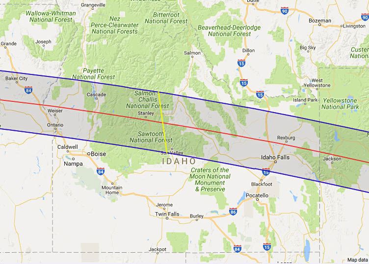
Google Map of 2017 Total Eclipse in Idaho
(Click to use interactive map)
The map above links to an interactive Google map showing the visibility of the Total Solar Eclipse of 2017 Aug 21 in Idaho. The interactive map allows the user to zoom and drag the map as desired. Click the cursor on any location to generate eclipse circumstances from that location.
Eclipse Circumstances for Cities in Idaho
The table below lists eclipse circumstances for a number of cities in Idaho. The following information is given for each city.
- The type of eclipse seen from the city (Partial or Total).
- The times when the partial eclipse begins and ends.
- The times when the total eclipse begins and ends.
- The time of maximum eclipse.
- The altitude on the Sun above the horizon (in degrees) at each of these times.
- The Eclipse Magnitude at maximum eclipse. Eclipse Magnitude is the fraction of the Sun’s diameter occulted by the Moon.
- The Eclipse Obscuration at maximum eclipse. Eclipse obscuration is the fraction of the Sun’s area occulted by the Moon.
- The Duration Total Eclipse is the length of the total phase in minutes and seconds (i.e., totality).
The times appearing in this table include Daylight Saving Time (DST) for all cities in which DST is observed. Report time zone or DST corrections for any city to EclipseWise.
Thanks to Bill Kramer (Eclipse-Chasers.com) for helping to develop the code to generate the above eclipse circumstances table. To calculate predictions for other cities see 2017 Eclipse Circumstances Calculator.
The partial phases require either a projection technique or a special solar filter to be viewed safely. On the other hand it is completely safe to watch Totality with the naked eye. For more information see Safe Solar Eclipse Viewing.
Animation of the Moon's Shadow Across Idaho
The animation above shows the Moon's umbral shadow as it tracks across Idaho. Observers must be inside this path to see the total eclipse. Outside the path only a partial eclipse is seen.
Animation courtesy of Michael Zeiler GreatAmericanEclipse.com.
States in the Path of Totality
The index below gives links to special pages for each of the 12 states in the path of the 2017 total solar eclipse. Note that the eclipse path also crosses a tiny corner of Montana and Iowa, but they are not included in this table.
| States in the Path of Totality | ||
Georgia |
Kentucky |
Oregon |
Idaho |
Missouri |
South Carolina |
Illinois |
Nebraska |
Tennessee |
Kansas |
North Carolina |
Wyoming |
Publications on the 2017 Total Solar Eclipse

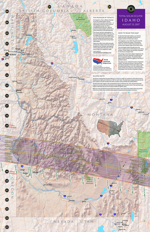
11" x 17" poster map of the 2017 eclipse path through Idaho
(GreatAmericanEclipse.com)
Additional Links for the 2017 Total Solar Eclipse
- Prime Page: Total Solar Eclipse of 2017 Aug 21 - EclipseWise general information on the eclipse
- Special News Page: Total Solar Eclipse of 2017 Aug 21 - major resources and links for the eclipse
- Orthographic Map: Total Solar Eclipse of 2017 Aug 21 - detailed map of eclipse visibility
- Animated Map: Total Solar Eclipse of 2017 Aug 21 - animated map of the Moon's shadows across Earth
- Google Map: Total Solar Eclipse of 2017 Aug 21 - interactive map of the eclipse path
- Path Table: Total Solar Eclipse of 2017 Aug 21 - coordinates of the central line and path limits
- Circumstances Table: Total Solar Eclipse of 2017 Aug 21 - eclipse times for hundreds of cities
- Saros 145 Table - data for all eclipses in the Saros series
- Total Solar Eclipse of 2017 Aug 21 - Google search for links to this eclipse
- 2017 Eclipse - American Astronomical Society (AAS)
- 2017 Eclipse in Idaho - GreatAmericanEclipse.com
- Detailed map of the 2017 eclipse path through Idaho - GreatAmericanEclipse.com
- Eclipse Communities in Idaho - Eclipse2017.org
- Eclipsophile.com - Weather for the 2017 Eclipse

Safe Solar Eclipse Glasses |

Rainbow Symphony Eclipse Shades |

Thousand Oaks Optical Solar Filters |

Great American Eclipse Store |
Links to Additional Solar Eclipse Information
- Home - home page of EclipseWise with predictions for both solar and lunar eclipses
- Solar Eclipses - primary page for solar eclipse predictions
- Solar Eclipse Links - detailed directory of links
- 21st Century Catalog of Solar Eclipses - including the years 2001 to 2100
- Total Solar Eclipses in the USA - maps for all total solar eclipses in the USA from 1001 to 3000
- Annular Solar Eclipses in the USA - maps for all annular solar eclipses in the USA from 1001 to 3000
- Hybrid Solar Eclipses in the USA - maps for all hybrid solar eclipses in the USA from 1001 to 3000
- Javascript Solar Eclipse Explorer - find all solar eclipses visible from a city
- MrEclipse.com - Eclipse resources and tips on photography
- Solar Eclipses for Beginners - a primer on solar eclipse basics
- Safe Solar Eclipse Viewing - summarizes several safe ways to view an eclipse of the Sun
- Solar Filter and Eclipse Glasses - a list of links
- Observing Solar Eclipses Safely - instructions for safely viewing an eclipse of the Sun
- How to Photograph a Solar Eclipse - instructions for imaging an eclipse of the Sun
- MrEclipse Photo Index - an index of solar eclipse photographs
Acknowledgments
Some in the JavaScript code used here is based on the work of Deirdre O'Byrne and Stephen McCann. Bill Kramer (Eclipse-Chasers.com) has expanded this code to work with dozens of cities.
The Besselian elements and values of ΔT used in these calculations are from Eclipse Bulletin: Total Solar Eclipse of 2017 August 21.
Permission is freely granted to reproduce this data when accompanied by an acknowledgment:
"Eclipse Predictions by Fred Espenak (EclipseWise.com)"